COLORADO, USA — The first half of February was very active in the mountains and on the Front Range with very few breaks in between storms. The computer models are showing a less active period for the second half of the month.
There will still be several chances for snow on the Front Range, but there should be a little more normal of a wait, with a few days separating storm events.
The last week of February is likely to feature a ridging pattern though, which would shut down the snow train for an extended period of time in the mountains and the Front Range.
This blog will watch all the developments in the computer forecast models, and will be updated once every day.
RELATED: Is Colorado on a 'polar coaster'?
RELATED: Is February the new March?
Wednesday Update
Feb 27
A wave of light mountain snow comes through Wednesday morning. Mostly just an inch or two.
A few snow showers on the northeast plains. Accumulation should be less than an inch in the spots that get the snow. Showers should be gone before noon.
I will end this blog feed and start a new one for the first couple weeks of March.
Chance of snow in Denver: 2%
Mar. 1-2
A storm to the south and north move across the country in the first couple days of March. The southern storm looks a little too far south, but the one from the north should make an impact.
In both runs of the Euro today, it has trended down with less of an impact to the Front Range and the previous two days. It now just show this storm as a basic 1-4" storm for the Denver area.
It should move onto the Front Range on Sunday evening after reaching fairly high daytime highs in the mid to upper 50's. So the first few hours of the storm should be rain.
After a few hours of darkness, along with the colder air being transported in, the rain should turn to snow, but continue to melt on the ground.
So far the Euro shows the heaviest snow between midnight and 6am Sunday morning, but accumulations only in the 1-4 inch range.
About the same potential for the eastern plains and the Palmer Divide, but it does show a little better potential for parts of the foothills.
GFS has come around a bit and now shows a similar solution to the new Euro.
Chance of snow in Denver: 50%
Mar. 3-4
Another storm comes in quickly from the north. This one looks a little colder and stronger in today's modeling but the snow numbers have come down a bit here as well.
The signal on this one is showing snow on Wednesday morning in the metro. Totals are being shown in the 1-4" range.
Chance of snow in Denver: 35%
Mar. 10
This signal is stronger in today's GFS runs. It shows a quick but powerful storm mostly impacting the San Juans. It also shows some snow in the Denver area as well, but less than an inch of accumulation.
Mar. 12-13
Mountain storm shown in this window, but no impact for the Front Range yet.
--------
Tuesday Update
Feb. 26 - Feb 27
This is a very weak impulse and a little too far from Colorado to have much of an impact, but it will be able to bring a couple days of light snow to the central and northern mountains.
Snow should startup sometime around noon Wednesday. Looks like 1-2" possible by Thursday night.
A few snow showers will be possible on the northeastern plains by Thursday morning. Not too many spots will see snow but the areas that do could get about a half inch of snow accumulation .
Chance of snow in Denver: 2%
Mar. 1-3
The average snowfall in Denver for the month of March is 11.4", and that could happen in the first 5 days. Good thing that we start out with a bang too because the rest of the month doesn't have too many great snow signals in it yet.
It starts out with 2 southern storm tracks bring snow to the Denver area on Sunday night into the day on Monday. The Euro has been showing about 3-6" with some bad timing for the morning commute on Monday.
Still some time but the Euro has been very consistent with a 2-4" or 3-6" storm in the metro.
To be fair, the GFS does not show much of an impact with this storm.
Chance of snow in Denver: 40%
Mar. 4-5
Then a northern tracking storm moves in right after. This would be quite a wallop if this track verifies as well. Euro had been showing about 1-4" storm for Denver up until today when it stepped up the game to another 3-6".
No way to tell how much snow is coming down the pipe, but this is a very strong signal so might want to prepare for a return to snow in Denver after a long hideous.
The timing for this one so far is late morning into the evening commute on Wednesday.
To be fair, the GFS does not show much of an impact with this storm either.
Chance of snow in Denver: 15%
Mar. 9-10
Weak signal but does show some light mountain snow possible.
Mar. 12
Mountain storm possible here.
--------
Monday Update
Feb. 25
Winter Weather Advisories will go into effect on the eastern plains at 5am Tuesday morning. Only 1-3" of snow is likely but the advisory is mainly for strong wind gusts creating blizzard-like conditions on the roads. Advisory goes to 5pm and includes parts of Wyoming, Nebraska, and Kansas.

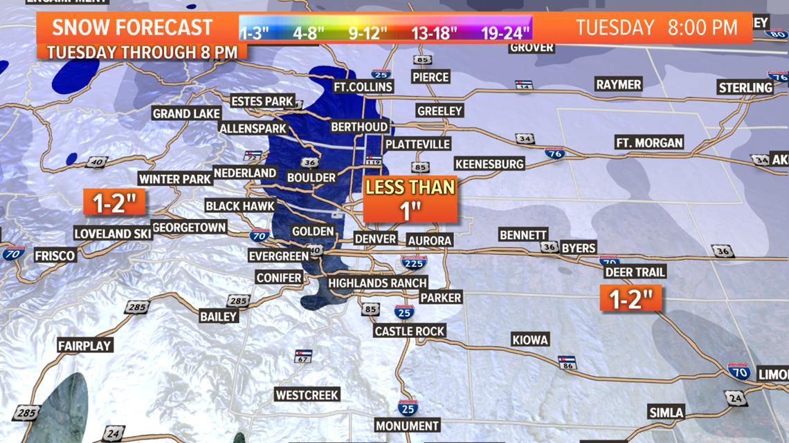
A few of these snow bands will make it into the Denver metro area by about 10am. Some areas could get up to an inch of snow. Winds will be a factor along the Front Range as well.
Chance of snow in Denver: 45%
Feb. 26 - Feb 27
This surge of cold comes straight out of the north, but just misses Colorado. Light mountain snow is possible with 1-3 inches in the northern and central mountains.
Then on Thursday morning, some snow showers will likely make it down to the Eastern Plains. A few locations could get about a half inch of snow. It is possible that one of those locations is close to the Denver area but not snow accumulation is not likely there.
Chance of snow in Denver: 5%
Mar. 1-3
It's been a while since we've had a decent chance of good widespread snow accumulation across the Denver metro. Feb 12 was the last time, but the first storm of March looks to be the next chance.
It looks like it may even be a 1-2 punch with a southern type track and then one from the north.
The Euro has been quite consistent with snow in the Denver metro area on Sunday evening into the day on Monday with solutions in the 2-4, and 3-6 inch range the last few runs.
Chance of snow in Denver: 30%
Mar. 4-5
This would be the second part of that punch. The Euro has just recently brought this into a position to also impact the Denver area on Wednesday and Thursday. A little less of an impact snow-wise though.
Chance of snow in Denver: 5%
Mar. 9-10
The signal for the second week of March is not as good as the first 5 days, so hope we get a good storm on Monday.
--------
Saturday Update
Feb. 23
No Winter Storm Warnings have been issued for tomorrows storm. The main reason for that is temperature. This is a very Spring-Like storm with warm temperatures.
That means, due to the apparent position the storm is coming in at, the Denver metro area will likely suffer in two phases of this system.
The first is warm temps. With overcast skies and rising dew points, the morning low will likely only be about 31 degrees in the metro. And with the bulk of the snow coming in the daylight hours, that temp will likely only rise throughout the storm. Could get as high as 34 or 35 degrees. That means almost all of the snow in the metro is likely to melt on impact. I still think it will be just heavy enough at times to lead to some accumulation though.
The second problem is that there is always a slot of dry air with the circulation of systems like this. That slot will likely be over the Denver area. That could cut the storms duration short, and even reduce some of the heavier squalls.
The spread for the metro will likely be between 1-4 inches, with a few of the higher locations getting close to 4 while most of us get 2 or less.
So this will be a very different storm from that last few this month because there is a lower chance of the snow sticking to the roads. Usually these things are more of a slushfest in Denver.
This is however a very wet system, and it will produce its own cold zone. That means someone may get slammed. That someone is likely on the east end of the Palmer Divide close to the Limon area.
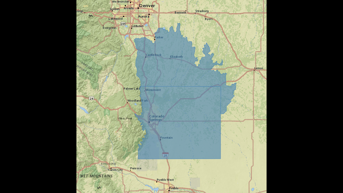
There is a Winter Weather Advisory in place for the Palmer Divide and the Colorado Springs metro area.
Feb. 24-25
There will be a couple more opportunities to pick up some snow on the Front Range on Monday and Tuesday, but not much in the way of accumulation.
A wave on Monday morning could bring a few spots a quick half inch or so, but with the line being pretty broken, most spots will not get anything.
Then flurries on Monday evening. No accumulation.
Then several flurries on Tuesday. Mostly less than an inch.
Chance of snow in Denver: 40%
Feb. 27 - Feb 28
Colorado will feel the presence of this storm moving by to the northeast. Some spots in the mountains and northeast plains may even get some snow showers, but accumulation is not likely.
Chance of snow in Denver: 0%
Mar. 1-3
Looks like a very good chance to kick of Denver's traditional snowiest month off with a winter storm on the Front Range. March will have a lot of work to do in order to catch this February, but this is a good way to start out.
Models show 2-4" in the metro at this point.
Chance of snow in Denver: 20%
Mar. 7-8
Storm in this window, but has looked different in 4 consecutive runs.
--------
Friday Update
Feb. 22-23
Well there is just 8 days left of winter (in meteorology, spring starts on March 1), and just like that, we are already dealing with our first spring-like winter storm.
That means high moisture content and warm temperatures will accompany the storm that is coming into Colorado tomorrow afternoon. The storm moves into the southwest part of our state before 3pm, and will bring a chance for thunderstorms, heavy snow, and thundersnow.
Winter Weather Advisories are in place for much of the mountains with 6-12 inches of snow possible on a few of the high mountain passes, and 4-8 inches on others.
Then on Saturday night, the storm moves onto the Front Range with scattered rain and snow showers. Temps will get up into the mid to upper 50's during the day, so snow accumulation will be unlikely before midnight on the Front Range.
There may be a little snow on the ground by sunrise though. Temperatures will probably be in the upper 20's and low 30's for this snow event during that day on Sunday.
At times, the snow will likely be very wet and heavy in the metro area during the day so it is possible for the snow to stick to the roads. Extra caution will be needed.
Much of the snow could be lost to melting and compression, so only about 1-4" is expected in the metro. A Winter Weather Advisory will possibly be issued tomorrow.
The focus of the snow on the Front Range will likely be on the Palmer Divide area. A Winter Storm Watch is in place there. 2-6" will be the most likely spread there, which includes Castle Rock, Elizabeth, Monument, and the Colorado Springs metro. It will be colder there, so the roads are likely to be quite messy.

Another place where very heavy snow is likely, is the I-70 corridor between Limon and Kansas. Models have been showing 2-6" in that area frequently, but there is a little less chance of it happening there than on the Palmer Divide.
Areas to the north of Denver, the foothills, and the northeast plains will see some snow as well, just not too much accumulation. Likely less than 3 inches.
Snow clears out of the Denver area just after sunset, but continues on the eastern plains until about 4am Monday morning.
Chance of snow in Denver: 100%
Feb. 24-25
It may feel like a continual storm from Sunday morning until Tuesday night because another disturbance moves down from the north right after. The wind and the snow showers will continue to pester.
Watch for a wave of snow showers to move through on Monday around noon or just after, and then another wave after noon on Tuesday. Most of us may not see any additional snow accumulation with these quick and broken showers though.
Models show some spots on the Front Range with a little more than an inch.
Chance of snow in Denver: 30%
Feb. 27 - Feb 28
This system is just close enough to leave on this feed but it doesn't look like much impact to Colorado.
Chance of snow in Denver: 0%
Mar. 1-3
This system has been gaining favor for some snow impacts to the Front Range. Looks like a good chance for our next snow in the Denver metro.
Chance of snow in Denver: 5%
Mar. 6-7
Nothing too consistent but still a storm signal here.
Mar. 7-8
Showing a mountain snow storm on these days.
--------
Thursday Update
Feb. 22-23
A closed low riding the southern branch of the jet stream will be moving into Colorado Saturday and Sunday. The computer models have gone from very enthusiastic to fairly sluggish over the last 24 hours.
Saturday will mainly just be mountain impacts. The snow totals are trending down overall from 6-12" on the mountain passes to just 4-8" in today's solutions. This would be a bit of a let down again for the San Juans, but they will take anything they can get down that way as it's been quite a while since the last decent snow.

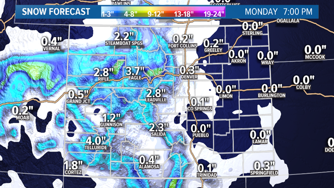
On Sunday morning, the storm will move over to the Front Range. Snow totals are trending down there as well, but models have consistently shown Sunday morning at about sunrise as the timing for the first snow accumulation in the Denver area.
Snow could take a bit of a break during the day, but chances go back up in the evening. Current solutions are showing about 1-3" in the metro area. Storm should clear out of Denver by midnight.
The Euro has dropped the blizzard solution for the eastern plains, but the GFS, even though it now strengthens the system a little further east, still has it close enough for good snow and wind on the plains.
I would count on snow in the Denver area on Sunday, most likely less than 3 inches for most of us.
If you live on the eastern plains, I would keep that blizzard possibility in the back of my mind, but not expect too much at this point.
Chance of snow in Denver: 30%
Feb. 24-25
This storm will be coming in from the northern branch of the jet stream and has reverted to the solution from two days ago. Which means it is trending down as well.
It will be a wave from the north with snow accumulation starting in the Denver area in the afternoon and lasting through Tuesday morning. 1-2" looks like the spread for now.
Chance of snow in Denver: 30%
Feb. 27 - Feb 28
This system looks too far to the northeast to impact Colorado. May have to remove it from the feed.
Feb. 29
Might have to remove this one as well because it is pretty much attached to the previous track.
Mar. 1-3
May be two quick systems moving northeast of Colorado. Doesn't look like much impact for us at this point.
Mar. 6-7
GFS does show this system hitting Colorado again today, but so far not to much action on the Front Range.
--------
Wednesday Update
Feb. 22-23
Very interesting storm system coming in from Southern California, so it should have some decent moisture in it, and the Euro is actually starting to match the GFS with it's solution impacting the Front Range as well as the eastern plains.
This is a little bit of a turnaround for the Euro but since the GFS has been consistent with it for a few days now, there is a good chance for impact with this signal.
The storm moves in the the mountains of southwest Colorado on Saturday afternoon and gradually spreads northeast.
Models are indicating that there could even be a few scattered snow showers on the Front Range by late Saturday night. The main impact is likely to be Sunday. Both models area showing roughly 3-6 inches in the Denver area, and possible blizzard conditions on the east I-70 corridor to Kansas.
This is a very small and cutoff low, so steering guidance on these things can be very weak. That means the forecast will often flip-flop a few times before it moves in. Confidence will always remain fairly low with these until about 36 hours out.
Chance of snow in Denver: 20%
Feb. 24-25
Then another storm moves in quickly from the northern branch of the Jet Stream. This storm looked like the more impactful storm just 24 hours ago in the models, but now it is the one taking a backseat.
This sudden flip in the models is a little concerning but we'll hope to see some consistency with these moving forward.
Now this one is only showing a few quick inches of snow in the Denver area.
Chance of snow in Denver: 25%
Feb. 27 - Feb 28
This storm is still showing from the north right behind the previous storm, but still not much impacts showing in Colorado.
Feb. 29
Big split in the models with this one. Euro shows snow on the last day of Feb. while the GFS shows warm and clear.
Mar. 2-3
This storm is still showing on the GFS with some impacts to the Denver metro.
Mar. 5-6
The GFS flipped into storm mode on this window today. No showing a storm where yesterdays runs showed none.
--------
Tuesday Update
Feb. 19
Another wave of snow showers is headed to the Front Range Wednesday. A few flurries will be possible tonight and early tomorrow morning, but it really doesn't fill in much until the afternoon hours.

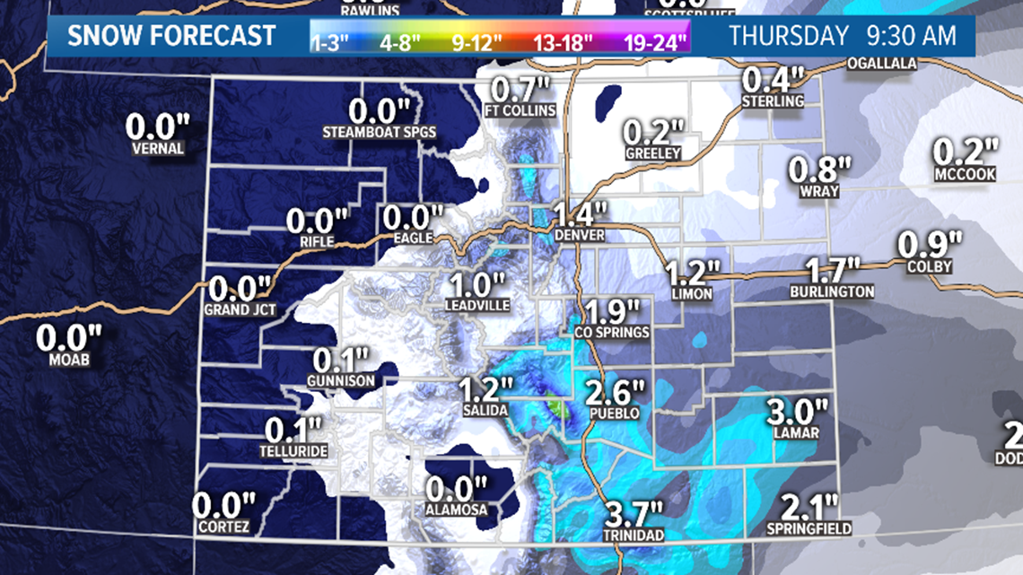
The snow totals will likely be very low in the Denver metro, mostly 1-2 inches with some spots slightly below and some slightly higher. The downtown Denver area will probably get less than an inch.
Storm should clear out of the metro by sunrise on Thursday.

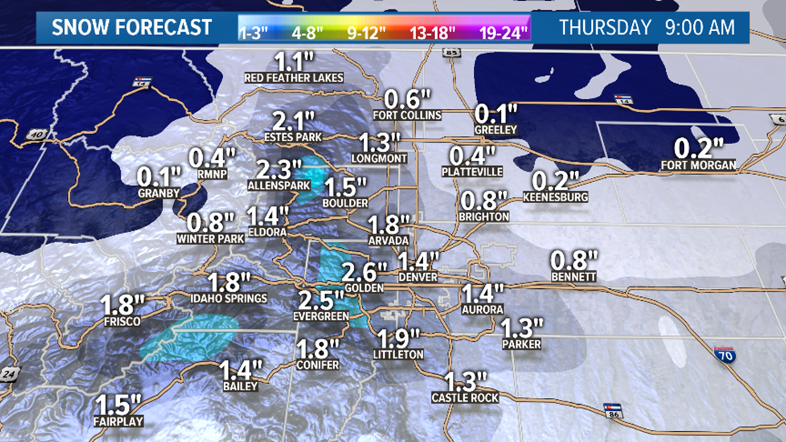
There's a little bit better of a potential on the Palmer Divide and the Foothills.
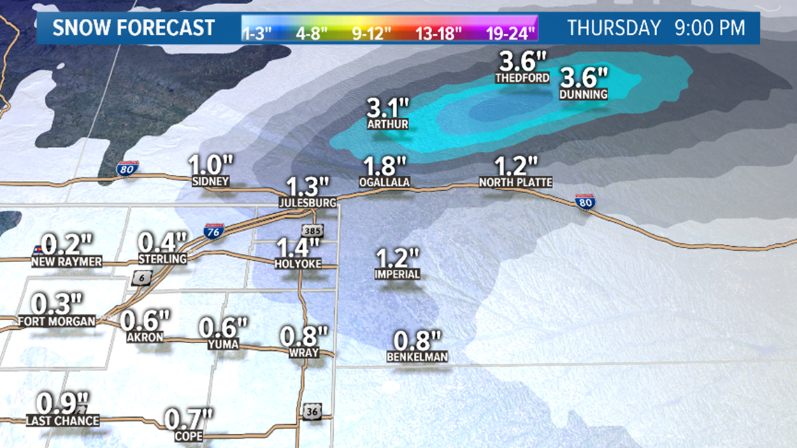
The eastern plains north of I-70 will likely get their typical dusting of 1 inch.

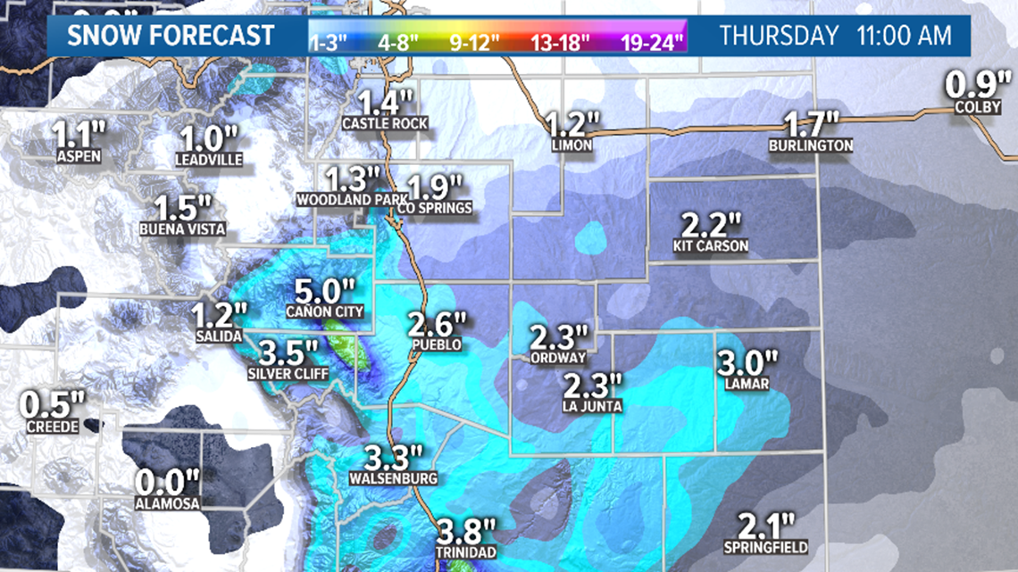
There is a Winter Weather Advisory in southern Colorado due to the possibility of 3-6 inches.
There is another advisory in parts of Nebraska for the potential for up to 5 inches of snow.

Feb. 22-23
A storm will hit the San Juans again in southwest Colorado — looks like maybe the 6-12 inch range on Saturday night. Winter Storm Warnings will likely come out for this storm.
It will also bring some light snow to parts of southeast Colorado and the Palmer Divide, and it looks like a little less than an inch in Colorado Springs and Castle Rock.
This will likely not bring any snow to the Denver area.
Chance of snow in Denver: 5% (Saturday night. Less than 1 inch)
Feb. 24-25
This storm looks like it has the potential to bring 1-3 inches of snow to the Denver over two separate waves. And maybe 3-6 inches for the central and northern mountains.
Chance of snow in Denver: 30%
Feb. 27 - Feb 28
There's a storm with some mountain snow showing. A couple runs have shown some light snow possible for the Denver metro.
Mar. 2-3
Trending a little closer to the Front Range in today's runs, but not much snow being shown.
Mar. 4-5
This window is clear again today.
--------
Monday Update
Feb. 18-19
This wave of snow will likely end before sunrise Tuesday morning in the Denver area, and then be followed by a couple more waves.
It will mostly be a trace to 2" in the metro area by 5am.
Then probably get a quick wave around sunset or just before that on Tuesday evening. It dries out again, so may not have any snow at all during the morning commute on Wednesday. But then it comes back mid morning and and lasts until about 5am Thursday morning.

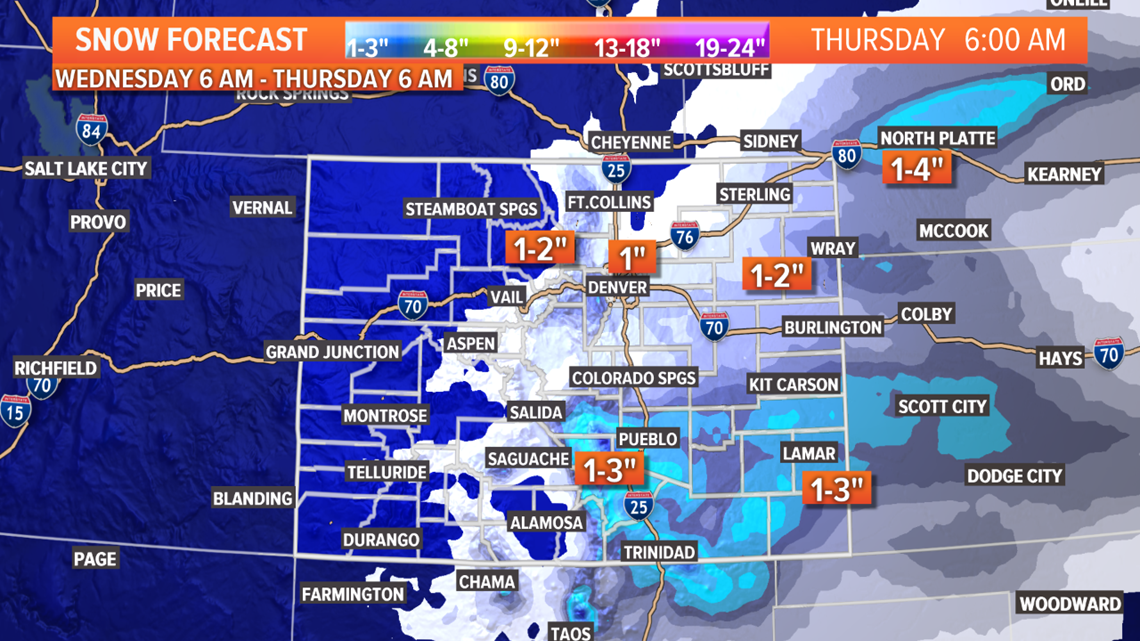
Another trace to 2" possible with those waves.
Breaks are a little shorter on the Palmer Divide so their numbers will be higher. When all these waves are over and you add up all the snow, El Paso and Pueblo County locations will most likely have the biggest numbers.
Eastern Plains and foothills also gets some snow. Not very much in the mountains but you may find a couple inches in spots.
Grand total at DIA will probably be about 2 inches.
Feb. 22-23
This storm has come across as a stronger system in the last couple model runs. Could even bring a few showers to the Denver area. For now it looks like 0-1" for the Denver metro, and 1-3" for the Colorado Springs metro.
Chance of snow in Denver: 5% (Saturday night. Less than 1")
Feb. 24-25
The signal is still strong for some snow in the Denver metro with this wave, however not will too big of an impact. Lookin like 1-3" Monday night into Tuesday.
Chance of snow in Denver: 20%
Feb. 27 - Feb 28
Storm with some mountain snow showing.
Mar. 2-3
This system made a second appearance in the modeling. Doesn't show impacts to the Front Range yet.
--------
Sunday Update
Feb. 17-19
The next chance for snow on the Front Range starts tonight and goes through about 7am on Monday morning. Widely scattered stuff, so not too many of us will see accumulation.
Some areas to the northwest, north, and northeast of the Denver metro may wake up to a dusting of snow tomorrow. Most likely less than 2" for those few spots that get a shower.
Will a slight warm layer, freezing rain could be possible as well. Maybe to the east of the Denver area.
Then a trough will likely bottom out and level off right over Colorado. That will give the Front Range several more chances to see snow all the way through Thursday morning.
Snow will develop around the Denver metro area on Monday afternoon, but no accumulation is likely until well after sunset. There will be some snow during the morning commute on Tuesday.
The Denver metro is looking at mostly totals around 1 inch, will some spots slightly below or slightly above that number by Tuesday night at noon.
Then it will likely dry out around the metro during the peak daylight hours, only to kick back in in the evening. Between Tuesday night and Wednesday night at 11pm, Denver could be looking at basically another 1 inch of snow with a few areas slightly lower and a few areas slightly higher than that number.
That means some more snow will be possible during the Wednesday morning and evening commutes. Should be no snow falling during the drive on Thursday morning though.
Denver's totals for the whole 3-day event will likely be between 1-3".
The Palmer Divide, El Paso County, and Pueblo County will have a little better potential. A Spread between 1-6" likely there with the Springs closest to 6.
The eastern plains has a little better potential than Denver as well. Same spread between 1-3" but more areas closer to 3 than the metro.
The foothills are in the 1-3" spread.
The higher parts of Boulder County has good potential to go over 4", while Eldora will get more than 6".
The Wet Mountains also has good potential to go over 6".
Chance of snow in Denver: 60%
Feb. 21-22
Light snow possible with this weak trough in the southern mountains.
Chance of snow in Denver: 0%
Feb. 24-26
Another day of strong modeling today showing snow on the Front Range in this window. Most likely time is Monday night into Tuesday morning.
Chance of snow in Denver: 10%
Feb. 27 - Feb 29
The weak signal in this window has disappeared in today's model runs.
Mar. 2-3
Small system showed up new in today's model.
--------
Saturday Update
Feb. 15-17
Our next storm has already moved into the Colorado high country tonight. This will deliver persistent snow showers to the central and northern mountains starting late Saturday night and through the entire day Sunday.
Snow could be very heavy at times, especially to the north. Mountain travel Sunday is not recommended for inexperienced drivers.
This storm will will attempt to push some showers down on to the Front Range early Sunday morning, but it is unlikely that anyone gets accumulation.

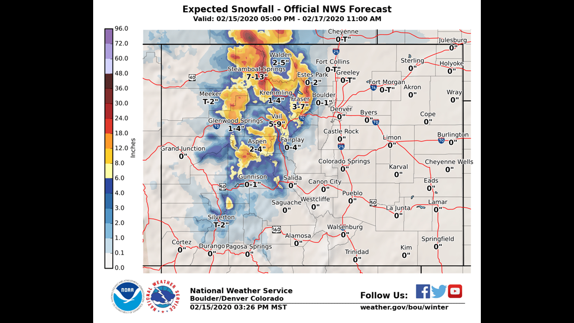
Then late Sunday night and very early on Monday morning, snow showers will be a little more successful in penetrating the Front Range. Some parts of the foothills and areas to the north of I-70 on the plains could wake up to a dusting or even some active snowfall. Likely less than 2" and just in a few lucky spots.
The models show the northwest Denver metro, the Boulder and Larimer County foothills and parts of Weld County as the most likely spots to get some snow, but it only shows about a half an inch.
Chance of snow in Denver: 10% (Possible Monday morning. Accumulation unlikely)
Feb. 17-18
Another storm moves in on Monday afternoon. This one will likely impact the Denver metro area on Monday night and Tuesday morning.
There will not likely be any snow accumulation in Denver until late. Like about 9pm, but there could be a few snow showers as early as sunset. There should be about a half inch to an inch spread throughout the area by midnight, but heavy snow may come on Tuesday.
The snow should start much early to the south near Colorado Springs. Also on the Palmer Divide.
The best probability is that we see 1-2" of snow in the Denver metro area by noon on Tuesday. Then it could clear out during the peak hours of daylight, and then return for another dose on Tuesday night lasting into Wednesday morning. We could get another 1-2" with that surge.
Even though the snow accumulation numbers are not impressive, the morning commutes on Tuesday and Wednesday morning will likely be slow in the metro.
The most significant snow on the Front Range continues to show for the Colorado Springs area with 4-6" by midnight on Wednesday. That's not a ton for 48 hour period, but it's still the highest amount on the probability charts.
The eastern plains should make out pretty good with this one. Models continue to be consistent showing roughly 2-4" except for the for northern sections. The areas on the south end of the Palmer Divide along Highway 24 could get more than 4 inches by Wednesday night.
The other big winner will likely be the Wet Mountains with 5-10 inches.
Chance of snow in Denver: 45%
Feb. 20-21
Light snow possible with this weak trough in the southern mountains.
Chance of snow in Denver: 0%
Feb. 24-26
Both models are sending a strong signal with all their runs today showing a strong storm system with upslope snow on the Front Range. Right now it looks like Monday night has the highest chance.
Chance of snow in Denver: 5%
Feb. 27 - Feb 29
Nothing too consistent yet but GFS has a storm in Colorado in this window.
Mar. 1-2
Currently nothing showing here yet.
--------
Friday Update
Feb. 14-15
This next storm will be hardly noticeable in Colorado. It actually moves in late tonight and will be gone by 9am Saturday morning. Some snow will be possible in the northern mountains, but it will only be on the high mountain passes and probably just an inch or two.
Denver will not be impacted other than a little colder air moving overnight.
Chance of snow in Denver: 0%
Feb. 15-17
This storm will be the second storm in this batch of three, and move in on Saturday shortly after the previous storm departs. It will mostly just impact the mountains.
There is a Winter Storm Watch out for the central and northern mountains. Some of higher passes will get between 10-15 inches with isolated spots close to 20". Mountain towns will vary with 2-4" in Summit County, while Steamboat Springs will probably get more than 10".
There will be a surge of snow showers that reach down to the Front Range on through the day on Sunday with maybe a dusting of snow in the foothills, but the better chance will be early Monday morning.
These showers will be battling downsloping winds, so I wouldn't expect much. The Denver metro could see a few flakes but probably no accumulation. Some areas to the north and northeast of Denver could get a band that gives you 2 inches or less.
Another storm will be moving in right behind this one though.
Chance of snow in Denver: 15% (Possible Monday morning. Accumulation unlikely)
Feb. 17-18
Then storm number three comes in. This one will likely deliver some snow to the Front Range.
Look for this storm to start making an impact on Monday afternoon or evening in Denver. Probably no accumulation until after dark. Looks like it will last through the Tuesday morning commute, so with low temps and snow sticking to the roads, that drive will likely be very slow.
Totals in the metro would be between 2-4" if this storm track holds. Yesterday's runs showed less impact, but at least the Euro has been generally consistent on this storm.
The GFS did have a run will large snow totals in its most recent run, but that model will have to be discarded from consideration for tonight due to major inconsistency and overall poor performance lately.
Overall, there is a trend upwards in impacts to the Denver area on Monday night and Tuesday morning though. The numbers have come down a little in southern Colorado a bit, but this storm still looks like it will favor the areas from Colorado Springs southward.
Chance of snow in Denver: 30%
Feb. 20-21
This storm is very weak and may not last in too many more runs, but for now it shows some light snow, mostly in the southern mountains.
Chance of snow in Denver: 0%
Feb. 24-26
Could be 1 or 2 storms in this window. Today's runs are showing some impacts to the Front Range but nothing solid yet.
Feb. 28 - Mar. 1
GFS shows a couple of storms nearby, but just missing Colorado.
--------
Feb. 15
The first storm system will miss Colorado by a long way to the north on Saturday, but we will still feel some impacts. The northern mountains could even get a quick dusting.
We may feel the cold air moving through on the Front Range but precipitation is unlikely.
Chance of snow in Denver: 2%
Feb. 16-18
This storm will provide the Front Range with the next chance for snow, although it doesn't look like much at this point. Probably a better chance for southeast Colorado.

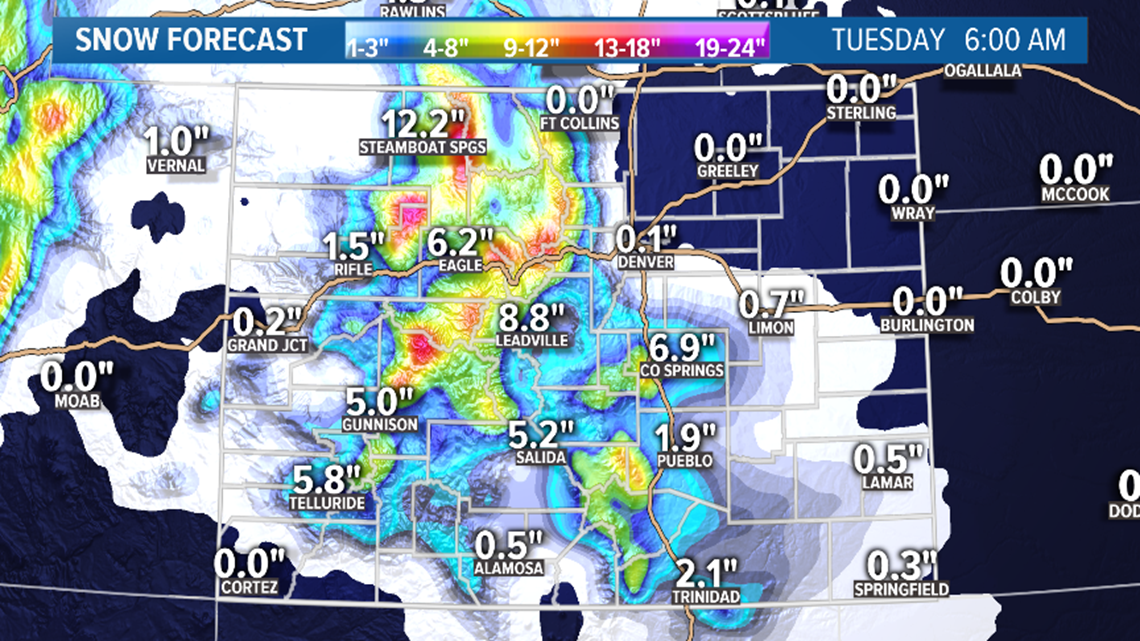
It will probably move into the northern mountains very late on Saturday night, and last for a couple days. So far we are looking at about 6-12 inches in the central and northern mountains.
We'll probably see a round of Winter Storm Warnings issued this weekend.
On Sunday morning, it will try to push into the Denver area, but not much will make it down. Then again on Sunday night into Monday morning, it will make a better surge through the day.
Denver probably won't get much put parts of the foothills and Palmer Divide could get an inch or two.
The I-25 corridor from Colorado Springs to Trinidad will have the best chance at getting decent snow Monday. Strong winds could even bring blizzard-like conditions there.
The southern mountains will get some snow out of this as well.
Chance of snow in Denver: 5%
Feb. 19-20
A quick little southern storm track right behind Monday's storm may bring some light impacts to parts of Colorado. The models have not been showing any impacts to the Front Range with this.
Chance of snow in Denver: 0%
Feb. 24-29
After a few days under a strong and warm ridge, it is not clear if Colorado will snap right back into action, or if the jet stream will ease us back in.
The GFS does show a few small storms in this window with impacts to the Front Range, but the Euro is showing a very slow rebuild into a storm period to start March.
Either way, there are not a lot of great storm signals existing for the rest of the month of the Front Range. The mountains should remain in good shape with the big storm in the mountains Sunday and Monday, along with just enough activity going into that ridge.
SUGGESTED VIDEOS | Science is cool

