DENVER — The heat records keep falling on the Front Range as a long heat wave hits its ninth consecutive day.
The streak is not a record. There have been a few daily high temperatures, but it's really the records surrounding the warm overnight low temperatures that's been grabbing attention.
The daily temperature has been measured on the campus of Colorado State University in Fort Collins for 127 years. And Tuesday was the warmest day ever recorded.
The maximum temperature was 98 degrees which is not too unusual. It’s hit 100 degrees 28 times in Ft. Collins. But the morning low temperature of 70 degrees was very unusual.
It’s only the 6th time in history that the low temperature was warmer 69 degrees. That made the average temperature for the day 84 degrees - the warmest day ever in Fort Collins.
“This is Colorado reckoning with climate change," said Jennifer Balch, a NOAA climate researcher and director of Earth Lab at CU Boulder. "That blessing of cooler nights, we’re losing that.”
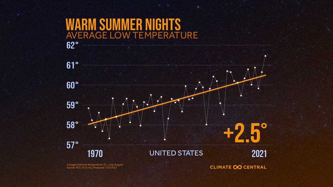
Balch said that summer nights are warming nearly twice as fast as summer days.
The average low temperature across the country is up two and a half degrees since 1970.


“It’s really important to acknowledge this because people and ecosystems need that recovery in terms of the temperature cooling at night," she said. "Our bodies can stay stressed and overheated if we don’t get that break. And our ecosystems also use the cool temperatures at night to recover moisture lost during the day."
Balch said when there’s a warm low temperature in the morning, it lengthens the amount of time we are exposed to high heat, and the high temperature can occur earlier than normal.
So far in Denver, this month has been the warmest first 19 days of any month in the 150 year history -- the morning low temperature has been 70 degrees or warmer 3 times. That hasn't happen since Denver's official climate station was downtown in 1943.
“It’s sort of an indication of how much we have our foot on the gas pedal in terms of temperature change, and how much are we losing the breaks,” she said.
Wildfire Impact
Balch’s expertise is in wildfire research, and she said wildfires are lasting longer, spreading faster, and growing larger than ever before because warmer nights are preventing overnight moisture recovery.
The study identifies a threshold that Balch calls flammable nights, when the nighttime weather conditions are just as conducive to wildfire spread as the daylight hours.
She said there is an average of seven more flammable nights per year worldwide, and 11 more in Colorado and the rest of the western U.S. That’s a 45% increase since 1979.
The measurement used to determine that threshold is called vapor pressure deficit.
“It’s a metric that captures both temperature and humidity together," said Balch. "It essentially measures how much moisture the atmosphere is sucking out of fuels.”
She said the warm nights are essentially the result of a feedback loop. A warmer atmosphere causes drier air at the surface. Drier air at the surface leads to increased nighttime temperatures. Higher nighttime temperatures leads to hotter days. Hotter days increases evapotranspiration which reinforces climate warming.
SUGGESTED VIDEOS: Colorado Climate

