DENVER — There’s cold, and then there’s sub-zero cold. And then there’s sub-zero cold immediately after 60-degree weather.
While a moderate snow event will move through on Monday night and Tuesday morning, the real story will be the bitterly cold temperatures accompanying our next snow event.
Temperatures will likely drop below zero at least twice this week, with consistently below-freezing temperatures likely for three straight days from Tuesday through Friday.
Wind chills in Denver will likely drop below zero from Tuesday morning through Thursday morning. This is dangerous cold: Bring your pets inside!

In addition to that, Denver will get 4 to 8 inches of snow, with the majority of it falling on Tuesday night and Wednesday morning. Parts of the mountains could get feet of snow from this system as well.
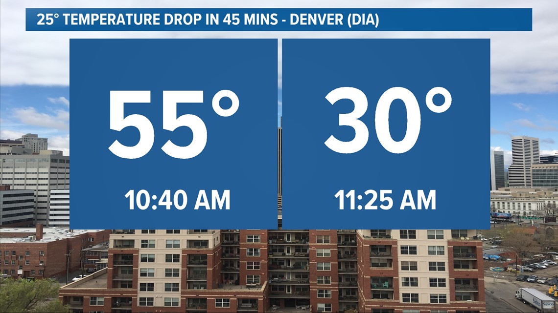
Of course, in classic Colorado fashion, temperatures spiked to 55 degrees on Monday morning ahead of this bitter Arctic blast. A cold front arrives on Monday, and behind it, temperatures will drop below zero for an extended period.
After the initial front moves through on Monday afternoon, snow will develop across most of the state. Initially, the snow will move into the mountains during the morning hours before dropping down into Denver and the Front Range after dark on Monday.
It may not entirely stop snowing in Denver until Thursday morning, although the majority of the snow on Tuesday and Wednesday will likely be very light.
The highest snow impacts will probably come on Tuesday morning, as the initial surge of snow moves through and potentially leads to a few inches of accumulation.
While the biting cold will be the big story, here's the really good news with this storm system, at least if you don't like snow and cold in the Denver area: It'll bring the mountains their first big snowstorm since early January.
As much as 2 feet (with locally higher amounts possible) could fall next week in the mountains, bringing them a needed wintry blast after a mostly snowless six weeks. Southern Colorado and specifically the San Juans, the Sangre de Cristo and Wet Mountains may end up with the highest totals from this storm.
That said, the mountains as a whole should end up with a widespread 1-2 feet of snow from this weekend's snow.
SUGGESTED VIDEOS: Science & Weather