COLORADO, USA — This snow blog follows any strong consistent signals in the long-range computer modeling.
It will be updated daily until the next time it snows in Denver.
This snow blog follows any strong consistent signals in the long-range computer modeling.
It will be updated daily until the next time it snows in Denver.
Thursday Update
Nov. 22
One last wave of snow with this strange storm system before it exits the state Friday evening.
This final wave of snow will likely begin before midnight tonight and could bring the potential for one more inch of snow for the Denver metro, and 2 or even 3 inches from the south metro down to Colorado Springs.

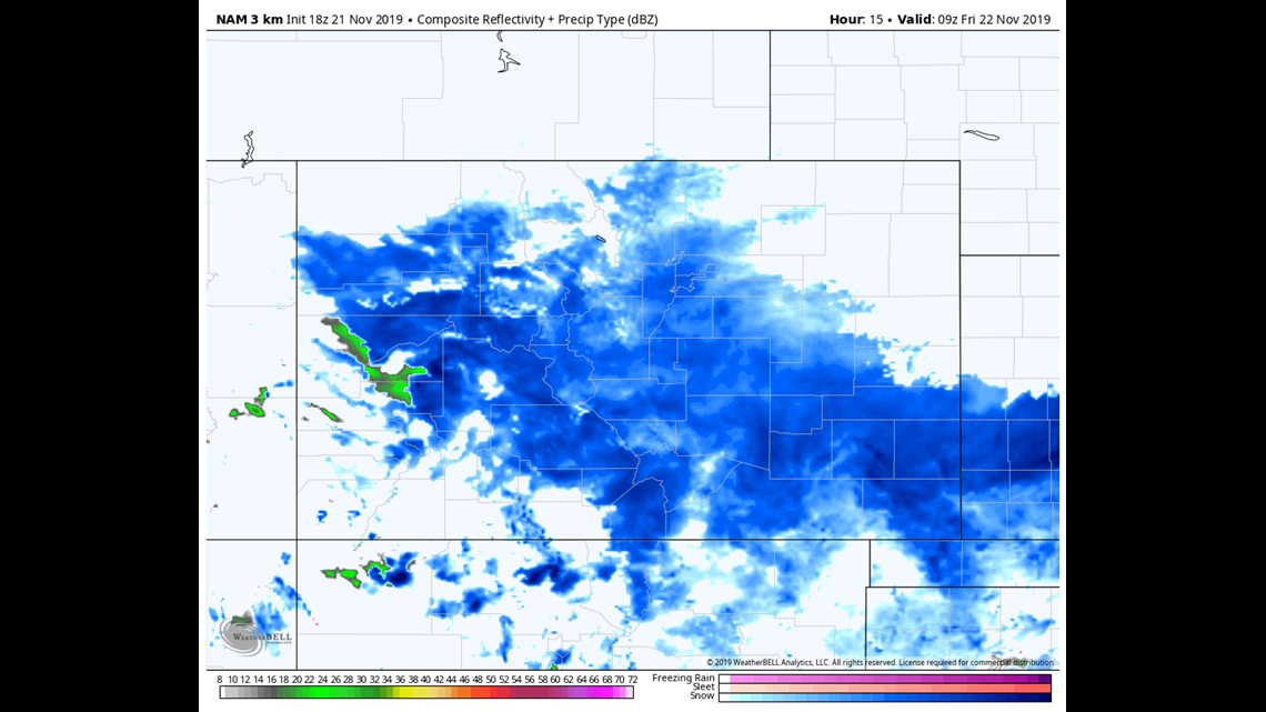
Models are not giving a great idea about when the snow will break up. The NAM shows it breaking up around 4am, while the HRRR has it lasting until 9am. Either way, plan on the morning commute being much slower than it was on Thursday. The roads will be cold enough to take on snow even with light snowfall rates.
At least there will be no freezing drizzle.
Nov. 25-27
Looks like the weather gods will spare us a nice weekend before the next winter storm moves in Monday. The models actually show snow starting in the northern mountains on Sunday night.
This will likely be a storm with impacts to the mountains, metros, and plains.
So far the track favors the northern mountains with 6-10 inches in the Indian Peaks, RMNP, the Park Range, and the Flattops. Looks like most of the snow will fall on Monday but some on Tuesday morning as well.
Both the Euro and the GFS are sticking to solutions of a fairly significant weather storm outside of the mountains as well. showing between 2-6 inches of snow accumulation in the Denver metro, foothills, Palmer Divide, and parts of the east plains.
Timing at this point has snow starting around 9 or 10am, with most of the snow falling on Monday, but lasting partially into Tuesday.
If this solution ends up verifying, there could be Winter Storm Warnings issued down low.
Chance of snow in Denver: 45%
Nov. 28-30
Another possible storm might be coming for Thanksgiving. The GFS is still indicating a mostly Western Slope and mountain storm. Eastern Slope could end also see some impacts though.
Chance of snow in Denver: 0%
Dec. 1-4
Models still holding on to a very active storm pattern all the way through December 4. Could be one or two more storms in this batch.
Chance of snow in Denver: 0%
---
Wednesday Update
Nov. 21-22
Since we are still only halfway through the most recent winter storm, I figured I would keep this blog feed going a couple more days.
We are in a little bit of a break in the storm waves tonight as I write this post. Looks like mostly scattered light snow showers for some of us overnight and into Thursday morning. Probably not enough to really add to snow accumulation totals except maybe in the foothills, but still mostly light there as well.
Thursday morning's commute in the Denver metro area could see some light flurries. Even those could be quite scattered. Temps will be below freezing so if there is a dose of heavier snow, it could very well stick to the highways, but that is not expected to be widespread.
The next wave of heavier snow is most likely to arrive around noon Thursday. That could come a little earlier. Not expecting that to be too impressive. Not as wet or thick as Wednesday night's wave.
Wouldn't be surprised if snow comes and goes all day Thursday.

The trough that dug down from the Pacific Northwest has been cut off and is progressing very slowly to the northeast. That has extended the snow forecast to about noon Friday.
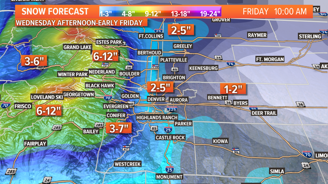
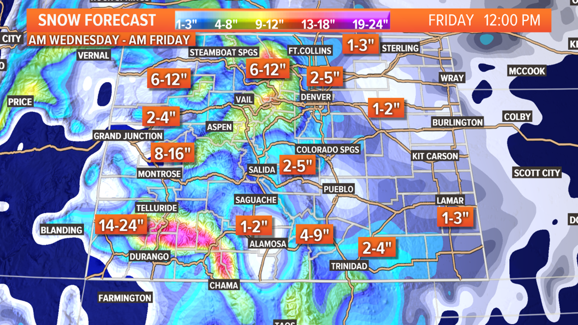
That wave could deliver a more steady and widespread snowfall. Friday morning's commute has more potential for trouble than Thursday morning, I would say. Even with the snow being extended a bit later into Friday, it doesn't look like any adjustments in expected snow will be needed. Still a spread of 1-4 inches of accumulation in the metro by Friday at noon.
Mountains should still get some heavy waves of snow. Warnings and Advisories remain in place.
Southeastern Colorado is still expected to get a wave of heavy snow on Thursday.

Nov. 25-27
Another Pacific Northwest trough will swing down toward Colorado after the weekend, and should start to impact the state on Monday morning. The GFS shows it moving close to the Four Corners position, but will likely not be stacked all the way down to the surface. Remaining mostly an upper level disturbance.
That will bring some more snow to the Central and Northern mountains, and will likely bring snow to the Front Range as well.
The GFS shows 1-4 inches in the Denver area. The Euro shows a more significant hit of snow, even some near blizzard conditions on the eastern plains. No agreement or too much consistency with the models on this one yet.
Chance of snow in Denver: 25%
Nov. 29-30
Another possible storm might be hot on the heels of the previous storm. So far, the GFS is billing it as a mostly Western Slope storm, with some impacts on the eastern side of Colorado.
The chances look very high for some areas of Colorado getting a White Thanksgiving.
Chance of snow in Denver: 0%
Dec. 1-4
Models still holding on to a very active storm pattern all the way through December 4. Could be one or two more storms in this batch.
Chance of snow in Denver: 0%
---
Tuesday Update
Nov. 19-22
Complex winter storm coming to Colorado tonight. A Pacific Northwest trough will merge with a upper cutoff low coming off of the Tropical East Pacific. They won't likely merge completely together, but will basically occupy the same space. Several different waves, and many different impacts depending on location.
Tuesday night- Scattered rain and snow showers move into the Western Slope by about 6pm. A thunderstorm or two are possible, with snow above 10,000 ft. Could get a couple inches of accumulation in the San Juans, Grand Mesa, and Flattops by midnight.
A few brief showers could spread into the central and northern mountains, but snow accumulation is not likely.

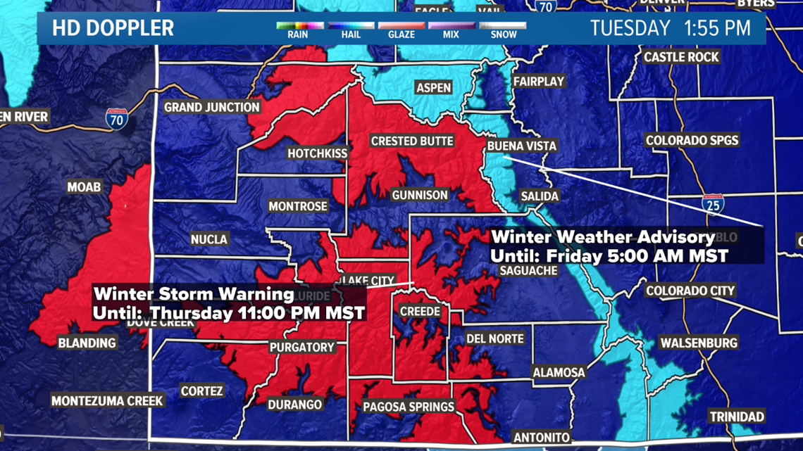
Wednesday morning- The first big wave of snow should hit the central mountains by about 8 or 9am. That includes the I-70 mountain corridor between Vail and Georgetown.
3-6 inches looks possible between 9am and 5pm Wednesday in the central mountains. Temperatures will be warm at first, near 32 degrees so melting is expected on the highway. Heavy snow could overcome the temps at some point and make I-70 pretty slippery during this time frame. There is a Winter Weather Advisory out for Eagle County, but nothing to the east just yet. A late addition here might be possible, which could go all the way to Lakewood/Golden at the Morrison Exit.

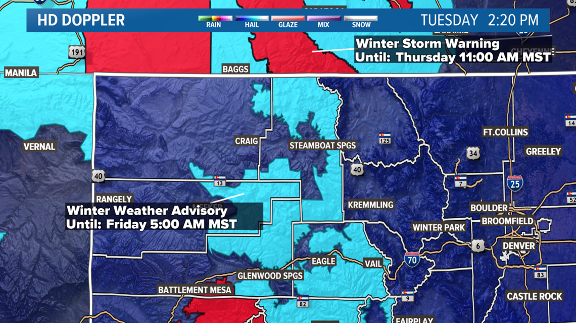
Winter Storm Warnings go from this evening, all the way until 5am Friday morning for the San Juans, stretching up through Gunnison County to the Grand Mesa.
285 through Park County could also get an advisory as 1-3 inches are possible before 11am.
Wednesday Afternoon-
Denver metro: Rain and snow will start to move into the metro areas sometime after noon. With temperatures in the mid to upper 30's until dark, it could likely be rain initially in the Denver metro area as well. From about noon to 4pm. Some areas to the west and south metro may get snow showers first.
Change to snow may happen just before or at sunset. The heavy rain and snow may only last a couple hours, transitioning to a light to moderate snow between 7pm into Thursday morning. Modeling has consistently shown between 1-3 inches in the metro, with most of that coming between 5pm and Midnight. Snow is not likely to stick the roads in many places.
Foothills and Palmer Divide: Higher terrain, means the precip will likely switch to snow a little earlier. The snow potential doesn't appear to be much higher though with a short-lived wave of good snow. Say between 2-3 inches there.
Colorado Springs: Dry downslope and higher temps will likely mean less snow accumulation. 0-" is the best probability there.
Ft. Collins and Greeley: Same issues as the Springs. 0-1" in those areas.
Plains: Northeast plains should see some snow, but with little accumulation. 0-1" there. The I-70 east corridor between DIA and Limon have a little better potential with the elevation and the contour of the northern edge of the Palmer Divide. 1-3" there. Eastern plains could see a pretty decent thunderstorm between 2-5pm, but snow accumulation is unlikely. 0-1" possible. The southeast plains will likely not see any action on Wednesday.

Thursday Morning-
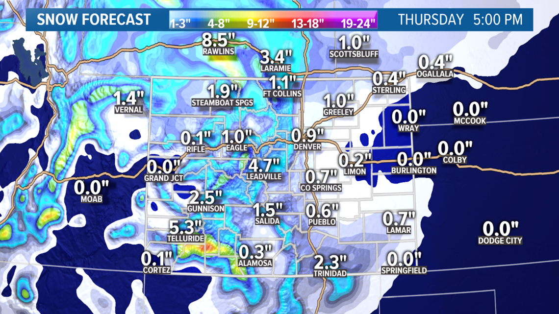
Denver metro: There will likely be active snowfall during the Thursday morning commute, however it will probably be pretty light for the most part. Temps will be down below freezing though, so potential for road slickness is higher.
There looks to be a second wave of heavier snow that should arrive sometime during the morning commute. It could wait until the tail end in the late morning, but I wouldn't count on it. Shouldn't last long, but could add another inch or so in a short amount of time.
Then light snow will be on and off during the day, with one more heavier dose possible in the late evening. Snow should stop before sunrise Friday.
Doesn't look to be much more than just an additional 1-3 inches accumulation. The snow from Wednesday will likely compress a bit through the day, so there may still only look like 1-5 inches on the ground by Friday morning.

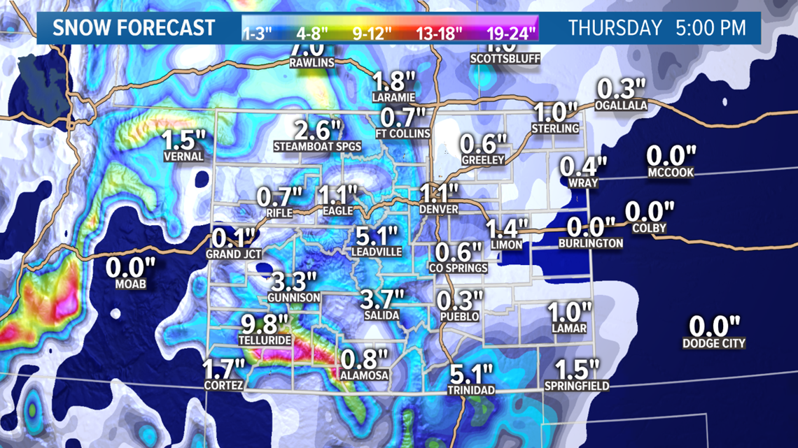
Foothills and Palmer Divide: Snow throughout the day there as well. Mostly light with a couple shortlasting waves of heavier snow. 2-5" storm total.
Colorado Springs: Snow throughout the day. 0-3" likely storm total.
Ft. Collins and Greeley: More breaks in the light snow likely up north. Could only get the two bigger waves. 0-2" storm total.
Plains: Northeast plains might only see a few moments of scattered light snow. Storm total 0-2". The I-70 east corridor between DIA and Limon could see a little more frequent snow. Storm total 1-4". Eastern plains could see some additional snow, but storm total will only be between 0-2 inches.
The southeast plains: Snow will likely be pretty steady on Thursday, with some extremely heavy snow on Raton Pass. Could get 2-4 inches on the plains, with 2-8 inches between Trinidad and Raton.
---
Monday Update
Nov. 19-22
Our next winter storm is right on the doorstep. It actually arrives tomorrow in the southwest part of Colorado with scattered rain and snow showers.
This is a very complex system where a trough will bend in from the Pacific Northwest and pick up a cutoff low from the tropical east Pacific. This will make this storm very interesting to watch unfold because that will inject a ton of moisture into this storm, and could affect the speed in which the system moves east.
The type of precip in Tuesday evenings storms on the Western Slope, will be all dependent upon how fast the airmass cools. I would expect to see some convective thunderstorms with lightning and hail, as well as some very heavy snow on some of the mountain passes. Could get a quick 2-4 inches by midnight.
Winter Storm Warnings start at 11pm Tuesday night in southwest Colorado.

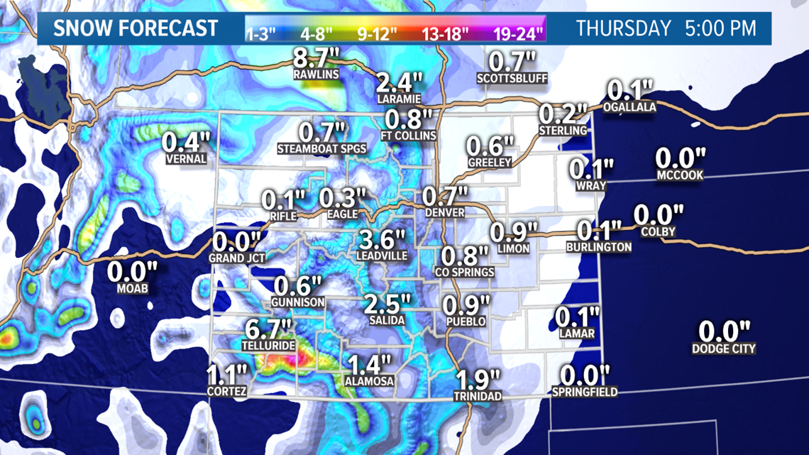
Storm might not really arrive on the Front Range until Wednesday morning, but there may be a few quick rain and snow showers on our side of the Continental Divide even before sunset.
It is still very difficult to tell how many waves of showers it will throw at the state. Mainly because of the little cutoff tropical low. That could stay independent and move through quickly, with the northwest trough right behind it.
After sunrise Wednesday, the showers will have a chance to get heavier, especially along the I-70 mountain corridor, the 285 mountains corridor, and I-25 on the Palmer Divide, but they will likely not stay steady. More coming and going.

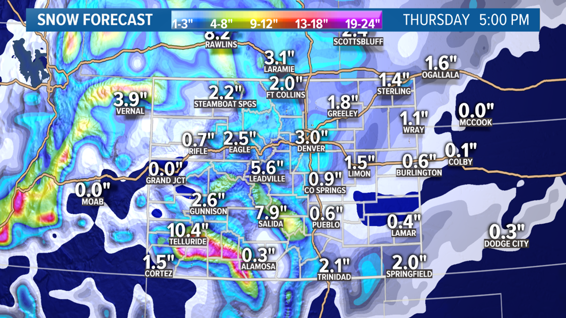
Looks like the bulk of the snow in the Denver area will be between noon and midnight on Wednesday, but there could be active snowfall all the way to noon on Thursday.
The bullseye is still on the southern part of the state. The town of Telluride could get 6-12 inches, while the ski hill could get 12-24 inches. Many of the passes like Red Mountain and Wolf Creek could be in the 12-24 range by Thursday afternoon.

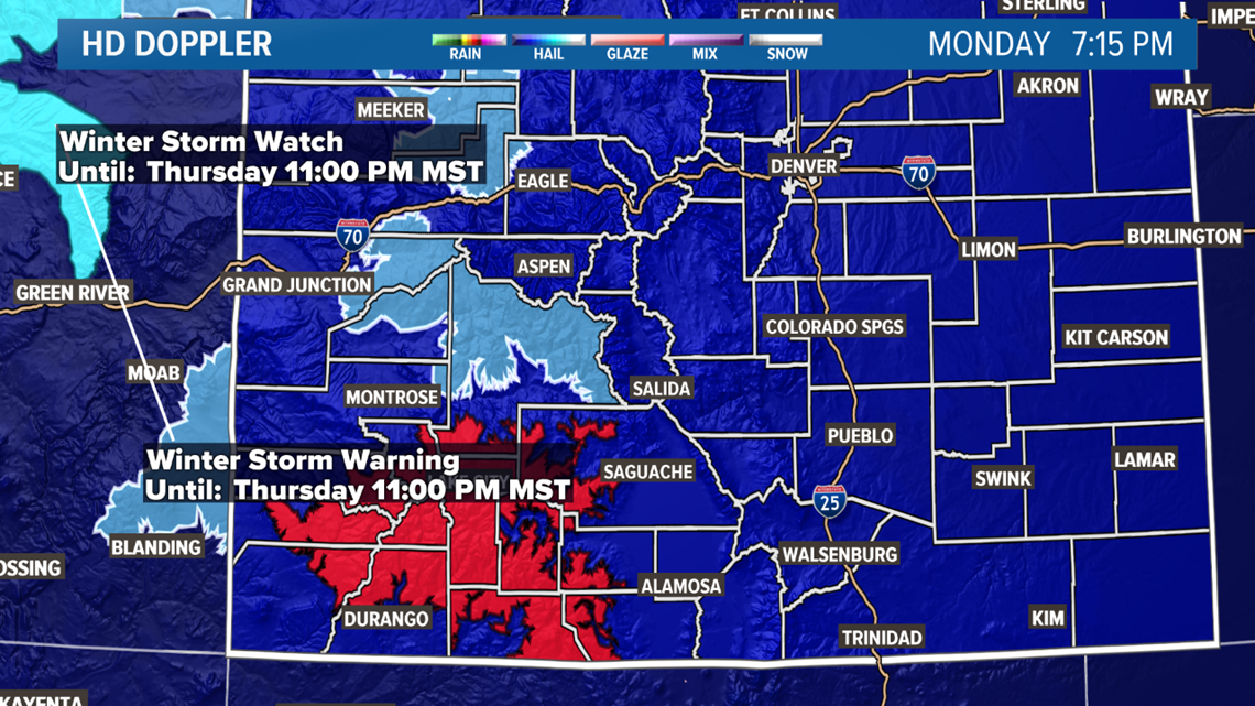
Looks like we could get 3-6 inches in the northern mountains including Hoosier, Loveland, and Berthoud passes.
The models are sticking to about 1-5 inches in the Denver area, with the higher amounts on the west and south side. A little less on the Palmer Divide due to topography. The lowest totals probably in places like Ft. Collins, Greeley, and Colorado Springs.
Storm probably won't completely exit the state until Friday morning before sunrise.
Chance of snow in Denver: 60%
Nov. 25-27
Storm pattern gives us a break on the weekend it would appear, and then another one comes in on Monday Nov 25. This also looks like a Pacific storm track.
This one will bring a little more snow to the mountains, but it doesn't look as potent as the first storm.
It could be just as good in the Denver area though. Models have been showing another 1-5 inches, with the higher totals in the metro foothills.
timing on this for the metro looks like Monday evening to Tuesday evening at the moment. With the heaviest snow on Tuesday morning.
Chance of snow in Denver: 15%
Nov. 29-30
Another possible storm next Friday. GFS just started breaking this one out of the bunch. This one has shown metro impacts so far.
Chance of snow in Denver: 0%
Dec. 3-4
The active pattern is likely to continue into December. GFS shows another storm with possible metro impacts.
Chance of snow in Denver: 0%
---
Saturday Update
Nov. 20-22
A big pattern switch is about to happen in our weather. The western ridge will break down on Wednesday for the first time in 28 days. This will open the door for the Colorado Rockies to get some much needed snow for the next couple weeks. This switch could even bring some snow to the Denver area.

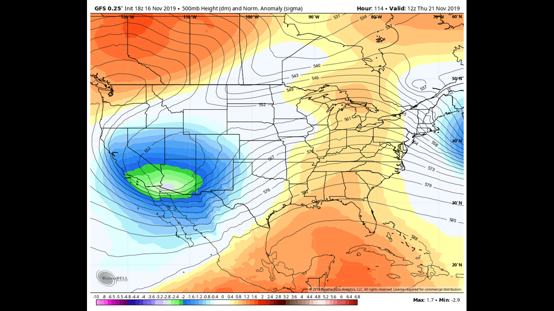
The first storm in this Pacific flow should arrive on Wednesday morning, with some snow in the southwest part of the state. The model solutions still favor the San Juans with the bulk of the snow. Could be looking at 8-12" if this path holds.
Both the GFS and the Euro are still showing snow spreading onto the Front Range by Wednesday afternoon, but with the bulk of the impact on Thursday morning.
GFS is in the 1-4 inch range for the metro, while the Euro shows 0-2.
Chance of snow in Denver: 30%
Nov. 25-30
The current timing for the second batch of snow has changed 3 times in the last 3 runs, but it does still show at least 1 more a storm in this time frame.
---
Friday Update
Nov. 16-17
A fast moving and weak storm system will move through the area Saturday afternoon. If it wasn't for a sharp cold front, most of us might not even notice that it's there.
The day should be pretty nice until close to sunset. Ft. Collins should get hit by the front around 4 or 5pm. Then the Denver Metro between 5 and 6pm. Temperatures will drop fast especially due to the timing near sunset when the temps are already dropping.
There will be some snow in the mountains, although it doesn't look like much. All the models are showing between 1-2 inches.
The GFS and the NAM have the metro areas and the foothills getting completely missed by any type of precipitation other than some brief drizzle. The Euro does show some snow showers in the foothills and even parts of the metro. Could get some snow but the chances are low and if it does happen, there will probably not be much accumulation other than a brief dusting.

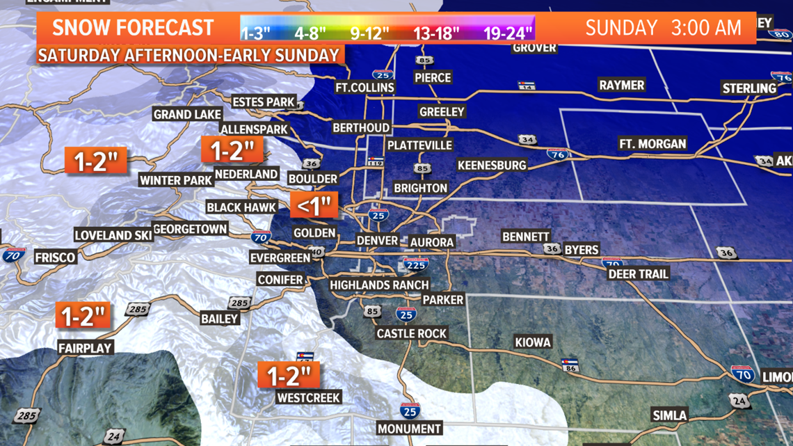
The Palmer Divide might have the best chance to see some snow other than the mountains. The NAM and the Euro show just enough to get a half inch or maybe an inch in spots there.
I rarely doubt the Euro in situations like this, so I feel that it's storm placement may be a little better, and we will see a few snow showers in the Denver metro area between 5pm and midnight. Doubt anyone will get a whole inch of snow in the grass, but maybe enough to see it on the ground.
It should be noted that the GFS and the NAM are totally dry with just some spotty drizzle, but either way there is not much impact from this storm other than a cold and dreary night.
Sun comes back out on Sunday, and it stays nice for a few days.
Chance of snow in Denver: 10%
Chance of accumulation in Denver: 2%
Nov. 20-22
A winter storm is still on track for Wednesday. The models have been very consistent about widespread impacts including the Denver metro and some of the eastern plains on Wednesday, but they are focusing the snow coverage in the San Juans. It appears this may be a southern storm track.
Chance of snow in Denver: 20%
Nov. 26-30
There is also a good signal for at least one more winter storm by the end of the month although right now it appears to be mostly just mountain impacts.
---
Thursday Update
Nov. 16-17
Just 3 days away from Saturday's storm, and the solutions are trending towards a weaker trough, and further away from Colorado. This storm won't move off the Pacific Ocean until tomorrow, so we won't know for sure until then, but it doesn't look good for snow lovers.
Models are now showing this fast moving system to start it's impacts to Colorado by about noon on Saturday with some light snow in the northern mountains. This is a big change from just yesterday when they indicated snow in the mountains all morning. They also have gone from 1-4 inches of snow there, to just 1-2 inches with nothing in the southern mountains.

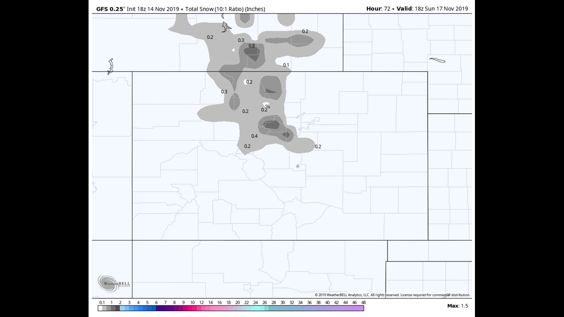
Then a wave of mostly light rain showers moves across the plains from the north. appears to be broken and light in nature so very few locations actually get wet. They do still show a brief chance for some snow showers on parts of the Palmer Divide after sunset, but accumulation pretty light. No snow shown for the foothills or the metro areas.
These new solutions would have almost zero impact on the Denver metro. Should know for sure tomorrow once the storm actually forms over land, so there is still hope for a change, but it doesn't look good for this storm.
Chance of snow in Denver: 5%
Chance of accumulation in Denver: 2%
Nov. 20-22
Next chance would be next Wednesday. Both models show a southern storm track move across the bottom of Colorado bringing snow to the mountains and plains Wednesday through Friday. Doesn't show much of an impact to the Denver area, but if this solution verifies, it would be real good news for southern Colorado. The winter drought situation has been growing there.
Chance of snow in Denver: 10%
Nov. 26-30
This active signal continues through the end of November. A month of 19 very dry days could end with a significant rescue in the last 8 days. That is an extreme way of having an average month, but that is how Colorado rolls. We will still need some good luck to get lined up by these storms.
---
Wednesday Update
Nov. 13-14
The tail end of a storm is moving through the area Wednesday night. There are some snow showers in the Cheyenne area northeast of Weld County at the time of this writing. The wave of snow showers will persist for a few hours as it moves to the south.

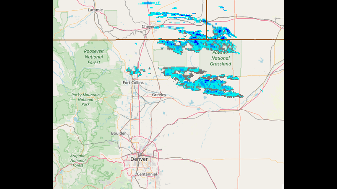
Very little snow accumulation is expected. The snow will even move close to the Denver metro area, so don't be too surprised if you see a few flakes out there.
The clouds break by sunrise, with a nice warmup for Thursday and Friday. Keep the slight chance of snow in Denver late tonight just because of the close proximity of showers.
Chance of snow in Denver: 2%
Nov. 16-17
A winter storm is forecast to arrive in Colorado early Saturday morning.
Snow showers will likely develop in the northern mountains by sunrise Saturday and last into Sunday morning. GFS shows a spread of between 1-4 inches except in the Wet Mountains and Sangres, where there could be more snow. Euro shows a similar scenario but with a bit less snow.
For the lower elevations temperature could be an issue. Precip will likely start out as rain after about noon in the Denver metro. Should turn over to snow on the west and south side, foothills and Palmer Divide, maybe before sunset.
Both the Euro and the GFS show temperatures too warm in the city for accumulation, but it will be close to cold enough. GFS shows 1-4 inches on the higher metro terrain, the foothills and the Palmer Divide. Euro again here shows just a little less.
Saturday could actually start out pretty nice down on the plains until the afternoon hours, so take advantage of the morning if you can. Storm could last into the early morning hours Sunday, but clear skies by sunrise.
Chance of snow in Denver: 20%
Chance of accumulation in Denver: 5%
Nov. 20-28
Models are still indicating an active storm pattern for the end of November. The first of a series of storms may be on Nov 20-21. Models have been showing a solution of some modest snow accumulation in Denver next Thursday. If that storm solution holds through tomorrow, I'll separate that first storm out of this batch.
---
Tuesday Update:
Nov. 13-14
There is a storm system diving in to Montana Tuesday night where some modest winter weather advisories are in place. The storm will just miss Colorado tomorrow but we will still feel some impacts from it.

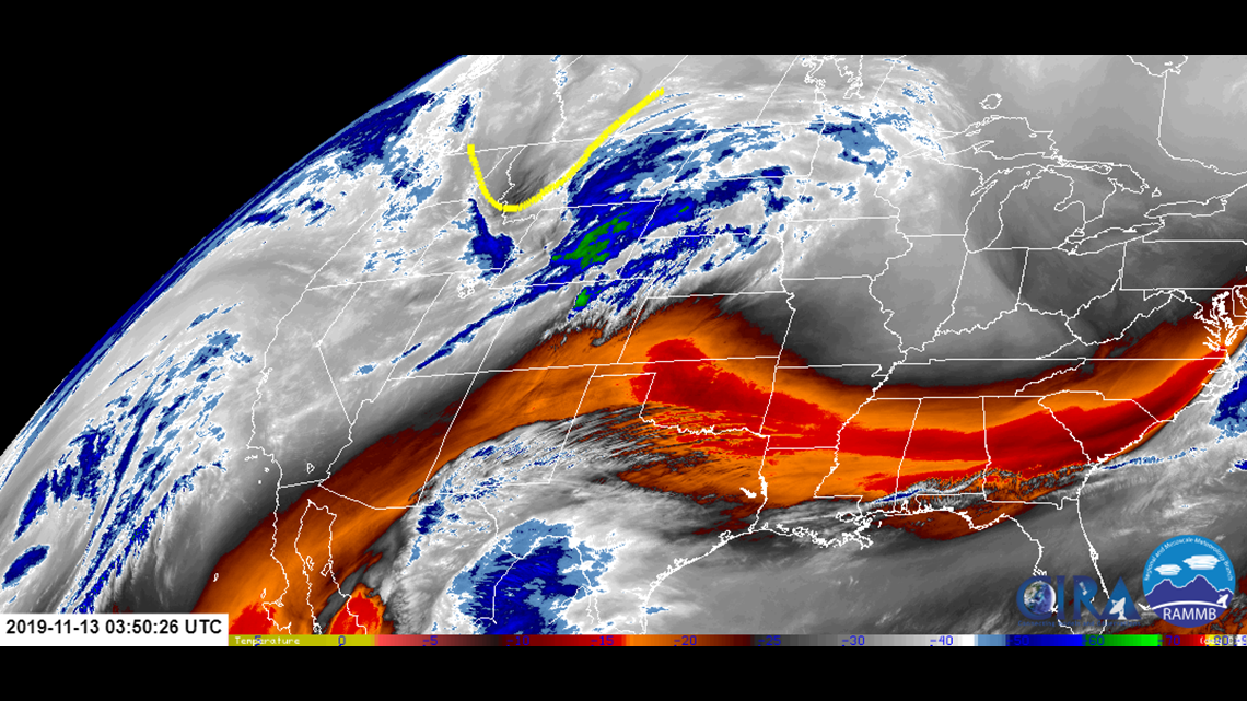
The storm could have a front and a back. Early Wednesday morning, along with strong downsloping winds, a cold front will arrive. That could bring some scattered bouts of freezing drizzle to the plains. Probably to the northeast and east of Denver if it happens.
Then light snow showers develop in the northern mountains above 11,000 feet. Mountain passes should remain fine for travel.
Then the backside of the storm late Wednesday night. The NAM and the Euro both show a wave of late snow showers moving down from the north. Mostly to the northeast and east of the Denver metro. Accumulation of snow is not very likely, but the Euro does show a dusting in a few spots.
The GFS continues its solution of no snow on the plains, and barely any on the peaks either.
I would leave a small chance for snow in the metro despite the dry downsloping winds. Mainly due to the close proximity of snow showers indicted by the Euro. Low impact either way.
Chance of snow in Denver: 5%
Nov. 16-17
The next storm which arrives in Colorado on Saturday morning will carry a more significant impact. Still has a decent chance to bring snow to the Denver metro as well.
This storm will have more of a Pacific Northwest origin, so there will be a higher moisture content, and warmer temperatures.
Models are showing snow showers developing in the high country sometime after midnight Friday. Both models are showing that low temperatures will hover right close to 32 degrees which means accumulation will be difficult. Elevation is key in storms like this.
The Euro shows 0-2 inches in the metro, 1-3 in the foothills, and 1-4 scattered in the mountains.
The GFS has 0-3 in the metro, 2-4 in the foothills and Palmer Divide, scattered 2-4 in the mountains, except for a bullseye down south in the Wet Mountains, and Sangre de Cristos.
Chance of snow in Denver: 15%
Nov. 20-28
Still no real separation can be distinguished between the active storm signal at the end of the month, but I am at least happy to report that the GFS is clinging to that active signal. It shows 3 separate Pacific storm systems between Nov 20 and 28. It hasn't made it passed the dreaded 8th day in the forecast window yet, so no point in getting too excited. Once we get within 7 days on the GFS, we can start to feel better about our snow loving selves.
---
Monday Update:
Nov. 13-14
This storm system is forecast to move into Colorado on Wednesday morning, and bring some snow showers to the northern mountains throughout the day and into Thursday morning.
RELATED: Read the full forecast
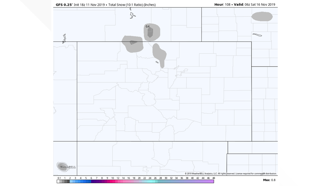
Modeling is showing a few inches in the Indian Peaks and Park Range above 11,000 feet. So far it doesn't look like much on the mountain passes.
Very little impact is expected on the plains. The GFS and the NAM show no snow, while the Euro only shows light accumulation on the plains north and east of Denver. Less than a half inch possible.

Chance of snow in Denver: 5%
Nov. 16-17
The signal on this storm has been much more significant than Wednesday's storm and may even be the next snow in Denver.
Models are showing some decent snow in parts of the mountains (3-6"), although not much in the southwest San Juans, where the snowpack is way behind average.
Timing appears to be early Saturday morning and lasting all day into Sunday morning.
The current solution on the GFS does not show snow in the Denver metro area but does have a couple of inches in the foothills and Palmer Divide.
The Euro has more snow indicated, including a few inches in the Denver area. It even has been showing significant snow in the western mountains and Sangres.
The two models are very different from each other, so obviously this is still a weak signal.
Chance of snow in Denver: 5%
Nov. 20-27
The Colorado mountains have been suffering through very dry stretch for the past 11 days, and that looks to continue for another 5 days, but there appears to be a pattern chance on the way for the end of November.
The most recent runs of the GFS have shown a jet stream pattern that could deliver 7 days of steady snow to the high country. It is early on this, so we'll have to wait to see how this gets separated, but the signal of a few Pacific originating storms is good news because they carry much more moisture than the arctic fronts.
SUGGESTED VIDEOS | Science is Cool


