COLORADO, USA — March is traditionally the snowiest month along the Front Range, but with just 6.5" measured so far at the official Denver climate station, it looks like February may be tops this season once again.
This blog watches winter storms develop in the long-range computer forecast models, and will be updated once a day.
Sunday Update:
Mar. 30
There is a trough moving through the Great Basin bringing light snow showers in parts of the mountains tonight. 1-3" of snow will fall by Monday night.
A wave of mixed rain and snow showers will impact the Front Range late tonight into Monday morning. There may even be enough snow to leave some snow accumulation.

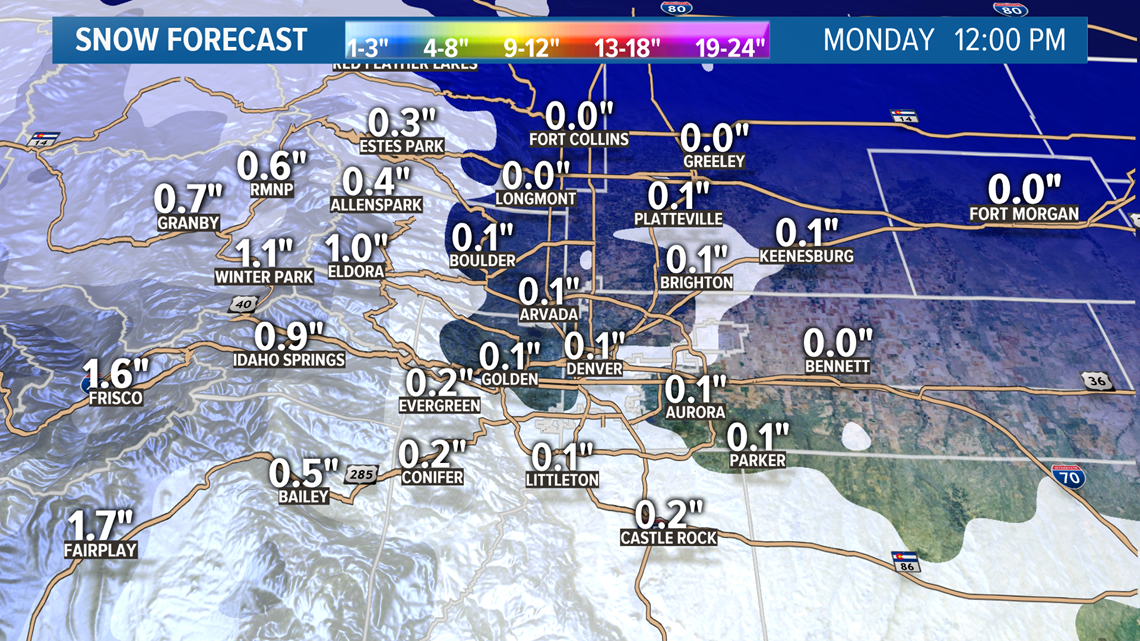
The most likely time for the snow showers on the Front Range will be between 3am and 9am. Models show some snow accumulation in the Denver area especially on the south side, but totals less than a quarter of an inch.
Chance of snow in Denver: 10%
Apr. 1-3
This solution is holding steady. I would expect to see some mixed rain and snow showers on the Front Range on Thursday night into Friday.
Models show only light accumulation of 1-2", with 1-3" in the mountains.
Chance of snow in Denver: 20%
Apr. 4-6
The solutions on this system today are still showing only mild impacts to Colorado again. This is a little bit of consistency but still a different solution. Yesterday the main trough was still to the north but also progressed quite a ways to the east, insinuating that the chances of a surge was passed. However today the main trough is to the northwest, meaning a surge could still be coming.
This solution today did not show enough snow for accumulation on the Front Range.
Chance of snow in Denver: 20%
Apr. 7-8
Again mostly mountains impacts shown with this system.
Apr. 9-11
Signal here has been very consistent. At least for the GFS.
Apr. 13-14
GFS shows this system too far from Colorado for impacts at this time.
------
Saturday Update:
Mar. 29-30
Another storm system will move through Colorado tomorrow and Monday.
Light snow accumulation in the mountains of 1-3".

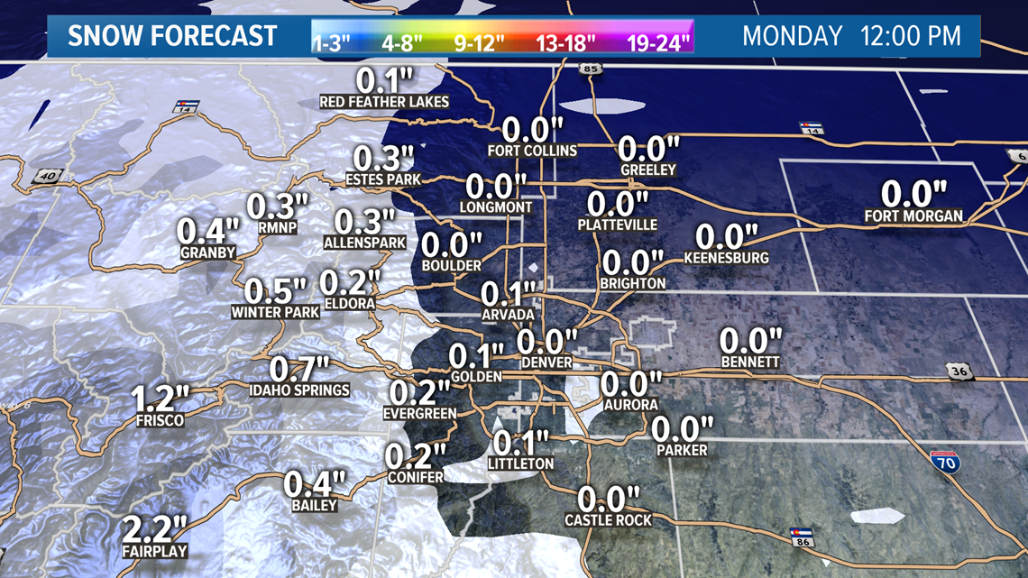
There will very likely be some mixed rain and snow showers on the Front Range on Sunday night into Monday morning. Models show just enough snow in there to get some accumulation but all areas less than a half inch.
No models show snow accumulation at DIA but it is possible to pick up a quick dusting Monday morning.
Chance of snow in Denver: 5%
Apr. 1-3
This storm system has not changed much in the models today. There will likely be some mixed rain and snow showers on the Front Range on Thursday. Models show light accumulation of 1-2", with 1-3" in the mountains.
Chance of snow in Denver: 15%
Apr. 4-6
This storm signal is still there but took a big hit in the Euro's solution. Both models have been showing a swirling trough to the north of Colorado for several days but can't really decide when there will be an opportunity to drop something down into our state.
It may come in this time frame, or perhaps in the next week but there is still a strong signal overall for a cold winter storm in the first half of April.
Today the models are only showing about an inch of snow on along the Front Range with this system on Saturday into Sunday.
The Euro has flipped on a storm system this winter in the 7-10 day period, but not yet inside of 6 so we'll see how it's solution unfolds tomorrow.
Chance of snow in Denver: 20%
Apr. 7-8
This storm system is showing again today but with little impact to the Front Range.
Apr. 9-10
Three days in a row with the GFS showing a storm system here with Front Range impacts although very different all 3 days.
Apr. 12-13
GFS shows this system too far from Colorado for impacts at this time.
------
Friday Update:
March 28
This winter storm will be wrapping up by about midnight on the Front Range, so less than an inch of snow between then and 5am when the snowfall stops.
The snow continues on the eastern plains until about 1pm on Saturday though, so there could be an additional 1-4" out there before the storm leaves the state completely.
Mar. 29-30
The next storm comes into Colorado on Sunday afternoon with some mountain snow showers mostly favoring the southern and central mountains. There will be 1-6" of snow possible over a 48 hour period from Sunday through Monday.
On the Front Range some mixed rain and snow showers will be possible on Sunday night into Monday morning. Snow accumulation is unlikely in Denver but some parts of the foothills and Palmer Divide could get up to an inch of snow.
Chance of snow in Denver: 5%
April 1 - Apr. 3
This solution has become much more clear in today's runs. It may carry two chances for some light snow accumulation on the Front Range.
The first chance will come late Wednesday night into Thursday morning. The Euro shows a quick chance to get about a half inch of snow accumulation in parts of the Denver area.
Then another chance on Friday morning with a chance for up to a half inch of snow again.
Models only show a little less than an inch of snow across the entire Front Range except for southern Wyoming and parts of the Colorado foothills.
Chance of snow in Denver: 10%
Apr. 4-6
There is still a very strong snow signal showing in the models for this time frame. Timing and duration will have to get worked out but this will likely be Aprils first significant winter storm.
Today the likely timing on the Front Range would be late Saturday night into Sunday. At the moment models show an extended storm period possible with snow into Monday as well.
Chance of snow in Denver: 20%
Apr. 7-8
Adding this timeframe in today now that the Euro shows a storm chance.
Apr. 10-12
This signal is present in the GFS runs again today. No impact shown to the metro though.
------
Thursday Update:
March 27-28
Winter Storm moves on to the Front Range tomorrow. Timing will be different in different areas this time.
The snow is already moving into southeastern Wyoming tonight. Could get 3-6" in Laramie, and 2-4" in Cheyenne by 2am Saturday morning. Warnings and Advisories are in place there.
There is also a Winter Weather Advisory in the northern Colorado mountains. 6-10" possible on Cameron Pass, and Rabbit Ears Pass. 3-6" possible on the Peak-to-Peak from Nederland to Ward, as well as Winter Park and Eldora. 2-4" in Estes Park. 1-2" in Steamboat Springs.

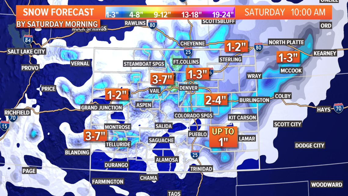
A mix of rain and snow showers will begin in Boulder and Ft. Collins around 10am. Those will be the first areas to get snow accumulation on the Front Range. Although just 0-3" is expected between those areas in total.
Could see some mixed rain and snow showers in the Denver metro area between noon and 6pm but not much in the way of measurements until after 6pm.
Heaviest snow in the metro will be from about 7pm to 3am Saturday morning.
Snow accumulation totals should be in the T-3" range.
Foothills and Palmer Divide will likely be in the 2-5" range.

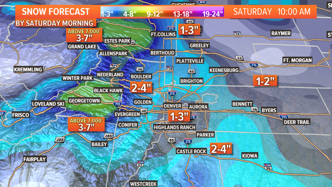
The north I-25 corridor between Thornton and Loveland may get less than an inch due to downsloping dry winds. That should include Greeley and most of Weld County as well.
The eastern plains south of I-76 and north of I-70 will get most of the moisture in the form of rain and snow.
Most of those spots should get between 2-4" of snow but the models continue to show a swath of totals in the 5-7" range. They have been showing that for about 5 days now, so I'd say that is a high probability.
There is no way to tell where that spot will be but the best chance is along the I-70 corridor between Watkins and Limon. Another potential location could be Washington County south of Highway 34. Places along Highway 36 between Last Chance and Cope.
No advisory has been issued there yet and may not at all due to the uncertainty of the location and the small area that it will likely cover.
Storm moves out of the Denver metro area by 4am Saturday morning and the eastern plains by noon. Light snow continues in the mountains through the end of Saturday.
Mar. 29-30
More rain and snow showers develop on Sunday and Monday. Could get a dusting of snow in the metro suburbs Monday morning.
The Colorado Springs area and the Palmer Divide could get up to an inch.
Chance of snow in Denver: 10%
Mar. 31 - Apr. 2
The solutions have changed with this system so I'm bringing it back. It is somewhat indistiguishable from the next system to follow, but the models do show some impact on the Front Range on the first day of April.
Chance of snow in Denver: 5%
Apr. 3-6
There has been a more consistent signal with this storm. Models have been showing some decent snow in the Denver area on that first Saturday of April.
Chance of snow in Denver: 15%
Apr. 10-11
Another storm chance being show here by the GFS model.
------
Wednesday Update:
March 27-28
Thursday will have some mountain snow showers with totals in the 1-4” range. Heaviest snow on Wolf Creek Pass.
There will also be some snow in Wyoming. 0-2” in Cheyenne and Laramie by midnight.
Front Range and eastern plains should stay pretty dry.
Then on Friday the bulk of this trough moves into the rest of Colorado. There could be a few light rain and snow showers on the Front Range but nothing too interesting until after noon.
The formation of the surface low on the eastern plains is trending a little later again so expect the first snow accumulation in the Denver area by about 7pm.
The spread of accumulation looks to be about 1-4” in the metro. Snow could be pretty heavy at times, but the main roads should stay mostly slushy.
The Palmer Divide and the foothills 3-6”. That includes the towns along the Peak-to-Peak.
Looks like there will be a downslope hole from the north Denver metro up to Ft. Collins, and Greeley. There will probably be less than 2 inches there.
There will be some snowfall amounts above 6 inches just to the northwest of the surface low so parts of the eastern plains will have a higher spread. The Euro has shown that spot to be along the east I-70 corridor between Watkins and Limon.
Winds will be strong an mainly out of the north but models continue to keep the peak sustained winds just below blizzard thresholds.
Storm should clear out of the Front Range before sunrise on Saturday and clear the eastern plains by noon.
Chance of snow in Denver: 90%
Mar. 29-31
Another system comes in on Sunday with some light snow showers in the mountains.
Then on Monday there will be some mixed snow and rain showers along the Front Range with some light snow accumulation of less than an inch in the metro suburbs.
This will be the last chance for snow in March.
Chance of snow in Denver: 10%
Apr. 3-5
Models are giving a strong signal for the first winter storm of April. Denver has recorded April snow 17 years in a row and this will likely be another.
So far they are showing snow in the Denver metro on that Saturday.
Chance of snow in Denver: 10%
Apr. 9-10
Snow chances are less frequent historically after March 15. The GFS shows a small storm signal here.
------
Tuesday Update:
March 25-28
There is another storm system sliding down the west coast of the U.S., and will start impacting the Colorado mountains with some light snow in the northern part of the state.
The I-70 mountain corridor will only get about an inch, while Steamboat Springs gets 3-6".
Snow showers will also be possible on the I-80 corridor from Cheyenne to Laramie.
On Thursday, the snow will be in the southern mountains with up to 12" possible on Wolf Creek Pass and 4-8" in the Sangres. There will also me some more snow will hit the I-80 corridor in Wyoming.
Not much snow on the Front Range other than parts of the foothills north of I-70 could get about a half inch. Only metro area to get snow accumulation might be Boulder, but that will only be less than a half inch.
Then on Friday the main part of the trough will come spinning through the state bringing snow to the Front Range and Eastern Plains.
There could be a few snow showers before noon, but the bulk of the snow will fall between 4pm and 4am.
While total moisture available with this storm hasn't changed too much, the snow accumulation numbers have gone up due to the arrival of the storm trending later on Friday.
The Euro is showing between 2-5" in the Denver metro area by 6am Saturday morning. That means we will likely see some pretty heavy snowfall rates of about 1" per hour especially on the east and south side of town.
There will be cold north winds again with this storm but so far the models are showing numbers just below blizzard thresholds.
While not many places are expecting more than 6", one of the likely places to go over is the I-70 east corridor between Watkins and Limon.
Both the Palmer Divide and the Foothills areas are showing mostly between 3-6".
The eastern plains and the Colorado Springs metro both are in the 1-4" range for now.
Storm is light in the metro after 4am, and completely gone by 8am.
Chance of snow in Denver: 85%
Mar. 29-31
Both models changed their solutions with this trailing system today. They now show a more connected trough instead of a split. That means we could see another round of snow in the Denver area on Monday morning and possibly Tuesday morning as well.
Looks like it could be 0-2" of accumulation.
This storm will have more impact on the southern mountains.
Chance of snow in Denver: 10%
Apr. 2-3
Second day in a row with this system not showing life in the models, so I'll drop this solution in the next update.
Chance of snow in Denver: 0%
Apr. 4-9
GFS shows a stormy period in this window but no consistent signal as of yet.
------
Monday Update:
March 24
Light snow continues in the mountains. About a half inch to an inch more in the central mountains. 1-3" in the northern mountains.
No precip at the lower elevations, excepts maybe a few drops along the Wyoming/Nebraska state line.
March 25-28
Another storm system moves into Colorado on Wednesday with some light snow in the northern mountains. No precipitation on the plains.
On Thursday there will be more widespread snow showers in the mountains, with a possible shot at some rain in the late evening hours to the north of the Denver area.
Some snow accumulation will be possible in the foothills and SE Wyoming before midnight.
Then on Friday the showers move into the Denver area. Could get some accumulation in spots by 9am, but the best chance for heavier snow will come in the afternoon.
Today's models area showing about 1-3" of accumulation in the metro, with a few spots over 4" on the Palmer Divide and Foothills. Storm moves out before sunrise on Saturday.
Chance of snow in Denver: 45%
Mar. 29-30
There will be another storm trailing right behind but solutions show it too far south to have much impact on Colorado other than some very light mountain snow showers.
Chance of snow in Denver: 0%
Apr. 2-3
This is a weak signal from the GFS and does not really show in the Euro now that it is in range.
Chance of snow in Denver: 0%
Apr. 5-8
This system is showing in the GFS solutions still but very weak signal.
------
Sunday Update:
March 23-24
Another storm system moves through on Monday and Tuesday.
1-5" will be possible in the mountains, but most areas will get less than 3".
Could get a few rain and snow mixed showers tomorrow morning. Mostly rain around the Denver area, with a bit more of a chance for a small and brief snow shower between Colorado Springs and Castle Rock. Might not be heavy enough for accumulation though.
Storm chances go up up in the afternoon. Could get a thunderstorm to the northeast and east of the Denver metro. Could even get a few drops of rain in town.
Some snow showers will continue in the mountains Tuesday.
Leave a slight chance to see a few flakes in Denver in the morning, but my guess is there won't be any rain or snow.
Chance of snow in Denver: 2%
March 25-28
This system has remain weak in the modeling today.
On Wednesday the showers will likely remain in the mountains except for areas well to the north of Denver between Ft. Collins and Cheyenne.
On Thursday the showers move closer to the Denver area. Probably snow in the foothills and rain in the metro. Models are showing some snow accumulation there on Thursday night though.
Friday looks to be the best chance for snow in the metro although the last couple runs have shown the system a little further south and quite weaker. Spread is showing to be slightly larger today but only 1-3" in the Denver area.
More mountain snow possible on Saturday morning.
Chance of snow in Denver: 30%
Mar. 29-30
This system held in today's models. Mostly mountain impacts still tough. Euro shows light snow accumulation in Castle Rock and Colorado Springs.
Chance of snow in Denver: 0%
Apr. 2-3
This storm is also still showing in today's runs. Still with mostly mountain impacts but snow in the foothills, and Palmer Divide looks possible.
Chance of snow in Denver: 0%
Apr. 5-7
GFS brought this system back today, after dropping the solution yesterday.
------
Saturday Update:
March 22
Another weak trough will move through the state on Sunday.
1-3" of snow in the mountains.
Mixed rain and snow showers will move onto the Front Range periodically amidst mostly downsloping westerly winds. Models show rain and snow possible in the Denver area between 7am and 5pm.
There will be some accumulation possible but likely less than an inch. Models show the best chance for snow in places like the foothills, Boulder, and the northwest Denver metro.
There is a little better chance for DIA to get measurable snow Sunday compared to Saturday, although none of the models do show that at this time. If it does happen it will probably only be a tenth of an inch.
Chance of snow in Denver: 10%
March 23-24
And yet another system moves through on Monday and Tuesday.
1-6" will be possible in the mountains, but most areas will get less than 3".
The first impact to the Front Range will come on Monday morning. Mixed rain and snow showers mainly south of Castle Rock. The Pikes Peak region could get some snow accumulation but likely less than a half inch.
Then on Monday afternoon and evening the showers will move north closer to Denver. It will most likely just be rain as temperatures will be too warm.
Thunderstorms likely on the northeast plains.
Tuesday's showers will remain in the mountains.
Chance of snow in Denver: 2%
March 25-28
This system is still showing in the modeling but a little weaker. It's actually going to be two more storm systems follow close behind.
On Wednesday the showers will likely remain in the mountains except for areas well to the north of Denver between Ft. Collins and Cheyenne.
On Thursday the showers move closer to the Denver area. Probably snow in the foothills and rain in the metro. Models are showing some snow accumulation there on Thursday night though.
Friday looks to be the best chance for snow in the metro although the last couple runs have shown the system a little further south and quite weaker. Snow accumulation is showing about 1-2".
More mountain snow possible on Saturday.
Chance of snow in Denver: 25%
Mar. 29-30
This last trailing system is still showing with slightly different timing though. Just light mountain impacts showing.
Chance of snow in Denver: 0%
Apr. 2-3
GFS showed this system again today with a chance for snow in the Denver area again.
Apr. 5-6
GFS dropped the solution on this system in todays runs.
-----------
Friday Update:
March 21-22
This very active weather pattern will continue in Colorado with one storm system after the next for the next 7 days.
SATURDAY
The snow will start back up Saturday morning in the high country focusing in on the San Juans where 2-6" of snow will be possible by midnight. There are no weather alerts currently issued for this storm.
About an inch will be possible in the central and northern mountains.
Then on Saturday afternoon the snow will try to creep in on the Denver area. Euro shows in mostly contained to the foothills and Palmer Divide, and probably less than an inch of accumulation.
You may catch a couple drops of rain in the metro, but rain showers are more likely on the eastern plains along I-70.
Chance of snow in Denver: 2%
SUNDAY
Then another wave of storm energy moves across the state on Sunday. 1-4" of snow will be possible in the central and northern mountains.
The Denver area could get a wave of mixed rain and snow showers from about 11am to 4pm. Euro does show just enough to get a measurement but less than a half inch.
Could get a quick dusting in the foothills and Palmer Divide as well. Measurable snow at DIA this weekend is not likely.
Chance of snow in Denver: 10%
March 23-24
Another storm moves in on Monday morning. About 1-4" of snow will be possible across the mountains.
Mixed rain and snow showers on the Front Range and the eastern plains in the afternoon and evening.
Models show some snow flurries possible in the Denver area but with no accumulation.
Chance of snow in Denver: 2%
Snow continues into Tuesday with another 1-3" of snow for the central and northern mountains.
Rain will try to make it down to the Front Range but it will likely not make it. Again, snow accumulation at DIA is not likely with these storms.
Chance of snow in Denver: 0%
March 25-27
Yet another storm system moves right in next. This one will probably be Denver's last chance at snow accumulation for March.
On Wednesday 1-5" of snow possible in the northern mountains. There will also be a wave of snow showers possible on the Front Range on Wednesday night into Thursday morning.
Euro shows less than an inch in the west metro, the foothills, and I-25 corridor north of Denver, but no accumulation at DIA.
Chance of snow in Denver: 5%
Then the storm gets its act together and moves some organized snow showers onto the Front Range on Thursday night into Friday morning.
Euro has shown a 3-6" storm in the last 2 runs for the Denver metro, foothills, Palmer Divide, and parts of the northeast plains. So far the timing shows most of it overnight Thursday and gone before noon on Friday.
Chance of snow in Denver: 25%
Mar. 30-31
Then finally we get our first break of more than 24 hours before the next storm rolls in the next Monday. GFS shows a slight chance for some snow in the Denver area Monday night into Tuesday morning.
Chance of snow in Denver: 0%
Apr. 2-3
GFS showed this system again today with a chance for snow in the Denver area again.
Apr. 5
GFS showed a small storm system here today.
-----------
Thursday Update:
March 20
Light snow and flurries continue along the Front Range. There could even be a few flakes around in the morning, but not enough for accumulation.
A wave of additional snow showers will develop in the afternoon though as the system makes a final exit. These showers will be possible between 2pm and midnight, but should be light and not everyone will get see them. Total accumulation will likely be less than an inch.
About 1-3" will be possible in total on Friday.
Chance of snow in Denver: 75%
March 21-22
These are actually two different systems back to back. There will be a slight chance for a mixed showers along the Front Range from Saturday evening into Sunday morning. Models are not showing any snow accumulation with these except maybe about a half inch on parts of the Palmer Divide.
Chance of snow in Denver: 5%
March 23-28
This period still looks like a very active storm period with a few storm systems in a train.
The first disturbance will bring mountain snow showers on Monday and Tuesday, but nothing down low.
The second wave looks more organized and should bring one last chance for snow on the Front Range. Euro shows 1-2" possible on the Front Range on Thursday night into Friday morning.
Chance of snow in Denver: 25%
Mar. 29-30
GFS still showing this storm system with some mountain impacts but no snow on the Front Range.
Chance of snow in Denver: 0%
Apr. 2-3
GFS shows a light mountain system here.
-----------
Wednesday Update:
March 18-20
The long-awaited winter storm is finally moving into the state. This is quite an unusual storm with up to an inch and a half of moisture available widespread across the Front Range.
With temperatures just cold enough, that should equal some really impressive snowfall rates on Thursday, along with sustained 35+ mph blizzard winds in other areas.

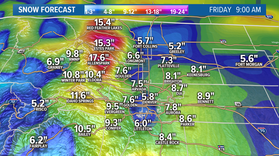
Look for the snow to pick up intensity in the mountains and foothills overnight. Rain is possible at first across the lower elevations, but that should change over to snow in the Denver area by about 8 a.m.
Heavy snow is likely on the Front Range between 8 a.m. and 8 p.m.

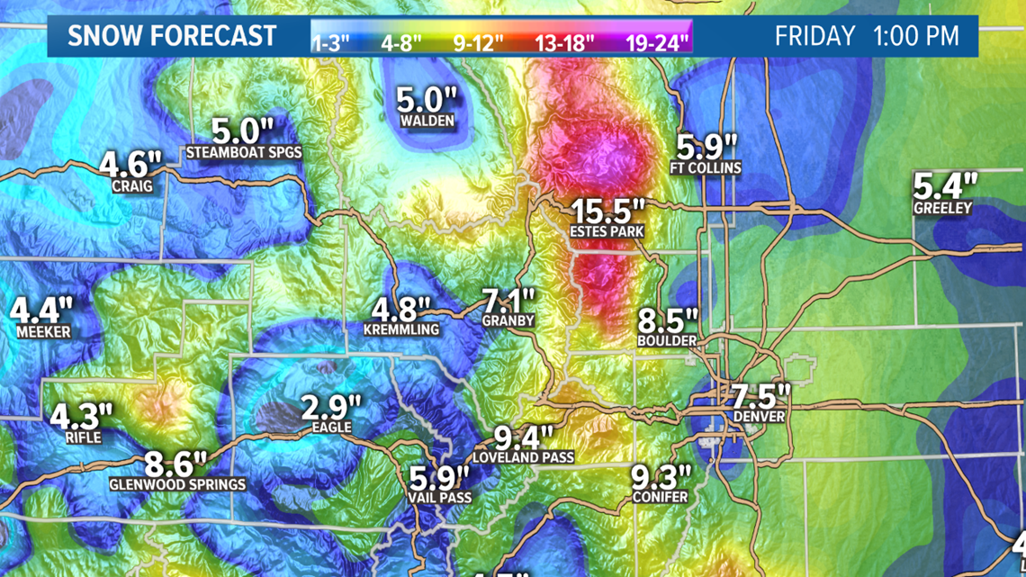
Total accumulation should be pretty impressive too. Four to eight inches of snow are possible across the metro with some spots at 9 inches or more.
Both the foothills and the Palmer Divide have a chance at a foot or more with the temps just a little colder at elevation.
Travel will be very difficult even with the lower traffic volumes expected. Heavy snow blowing in, and strong winds equals low visibility.
There won't be too much snow to the south of US 24.
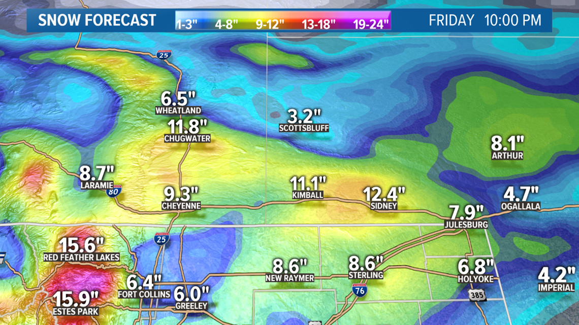
The northeastern plains east of Ft. Morgan and Limon will get much less snow accumulation -- probably in the 2-4" range. The trouble there will be the blizzard winds of 20 to 40 mph gusting to 55.

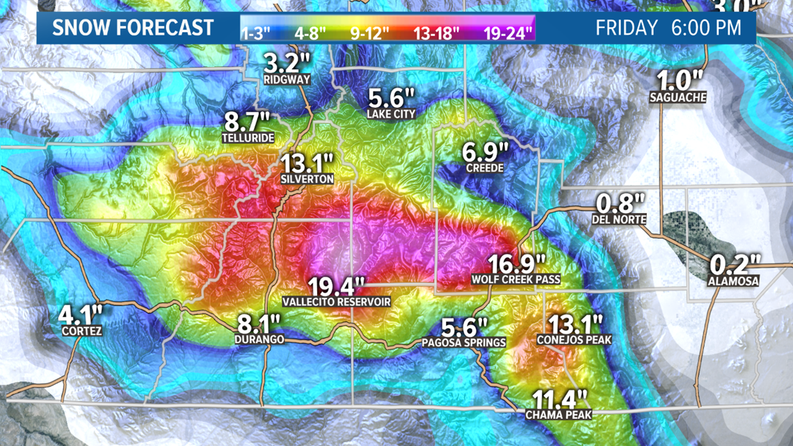
The San Juans may very likely be the hardest hit mountain location with 10-20" possible in spots, and 4-8" in the mountain towns.

The bulk of this storm will be over before sunrise on Friday, but additional snow showers will be likely in the afternoon and evening. Some spots around the metro could get an another inch or so.
March 21-22
Another quick upper level disturbance moves through right after. Some mountain passes could get 1-4" of snow but it doesn't look like much action for the Front Range.
A wave of mixed rain and snow showers will be possible Saturday night into Sunday morning, but I doubt the Front Range gets any of that.
Chance of snow in Denver: 5%
March 24-28
I tried separating this sequence of storm systems but it really looks like they will run so consecutive that it will be hard to distinguish on the ground.
With the first wave it will be mostly light mountain snow with a chance for mixed showers on the Front Range Tuesday. Snow accumulation looks unlikely.
The second wave looks more organized and should bring one last chance for snow on the Front Range. So far it's looking like 1-3".
Chance of snow in Denver: 20%
Mar. 30-31
GFS does show one last system in this bunch on the last two days of March. This is not yet in range of the high resolution Euro yet. GFS does not show snow accumulation on the Front Range though.
Apr. 3
GFS shows a light mountain system here.
-----------
Tuesday Update:
March 18-20
That powerful winter storm moves into Colorado tomorrow.
MOUNTAINS
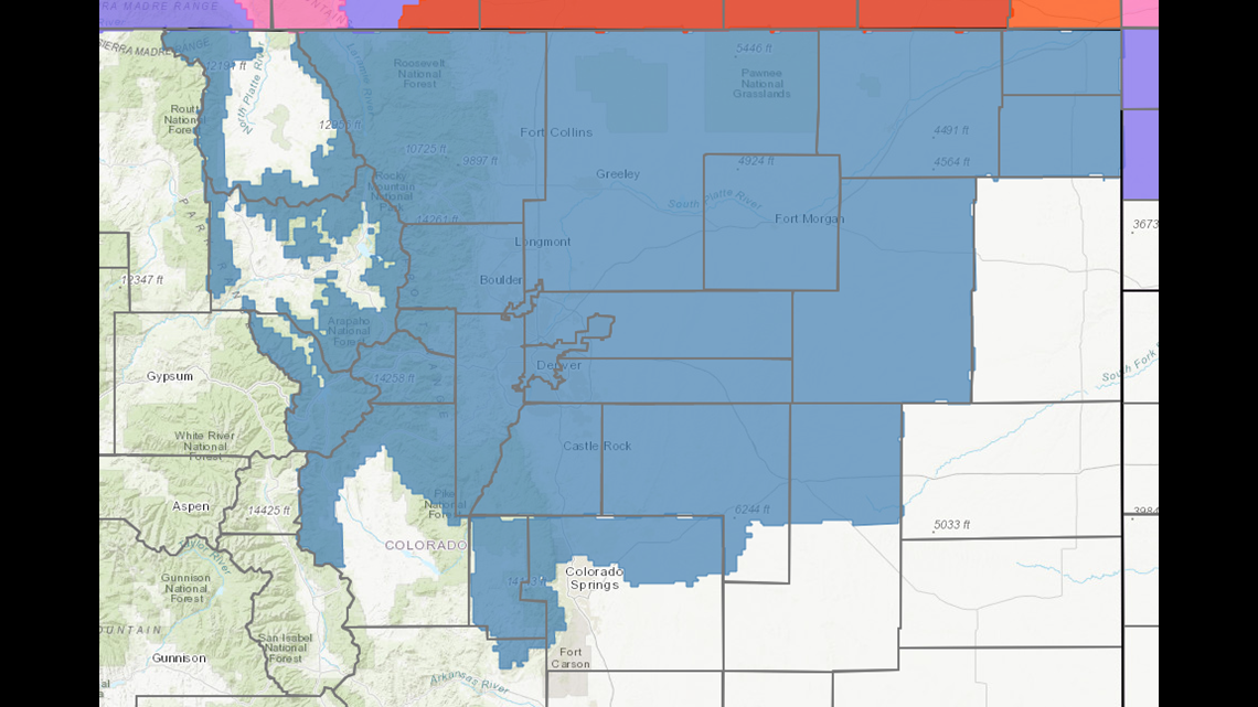
It will just be the mountains with impacts on Wednesday. Winter Weather Advisories cover most of the high country. 8-18" of snow on the mountain passes, and 3-7" in the mountain towns.
There is a Winter Storm Watch in a few parts of the San Juans like Wolf Creek Pass where 10-20" of snow is possible.
A Winter Storm Watch covers most of the Front Range and northeastern plains at this time. That watch will be separated into Warnings, and Advisories soon. Some of those warnings could be blizzard warnings along the northern state line.

DENVER METRO
The Denver area is looking as a round of very heavy snowfall Thursday following some brief rain early in the morning before sunrise.
The ground will be warm, the temperatures will be relatively warm in the middle to low 30's, the snow will be wet, and the strong spring sunshine above will impact the cloud tops.
There will likely be some very heavy snowfall rates as well, so there will be plenty of that wet heavy snow accumulation and weighing down tree limbs. The heaviest rates will be possible between 10am and 8pm.
Despite all the melting, the metro should still be able to get between 3-7" of accumulation. The spread may end up being wider that 4 inches, but the most likely odds are for most of us to fall into those amounts.
The Euro is still showing quite a few 8-9" totals in the area, but that may only end up being on very cold and well shaped surfaces.
The storm will be over before sunrise on Friday except for a few flurries that will not lead to additional accumulation. There will be more snow showers in the afternoon and evening though as the storm makes it's final exit. Those showers will likely lead to more accumulation in some parts of the metro.
FOOTHILLS
All of the foothills between 7000-9500 feet in Larimer, Boulder, Gilpin, Jefferson, Clear Creek, Park, and Douglas counties will have a chance to pick up between 8-18" with a few spots with more.
PALMER DIVIDE
Douglas, Arapahoe, Elbert, as well as the northern parts of El Paso and Teller county have a good chance to get between 4-9" of snow.
OUTER METRO
East Boulder County 6-9". While lower parts of Larimer County could even get a blizzard warning as the sustained winds could be 35+mph. Same goes for Weld County, with the southwestern part of the county getting the most snow.
EASTERN PLAINS
Less impact east of Kiowa, Deer Trail, and Wiggins but there may still be a winter weather advisory in areas. 1-4" of snow possible with the winds just slightly lower.
NORTHEAST CORNER
This area seems like a bit of a wild card. Logan, Phillips, and Sedgwick counties could very well get blizzard strength winds, and some areas there could also get more than 4 inches of snow, so I wouldn't be surprised with any alert the NWS issues there.
SOUTHEAST WYOMING and NEBRASKA PANHANDLE
There has been very consistent signals in the modeling for blizzard conditions here. 4-9" of snow accumulation, 20-40 mph sustained winds, and snow drifts well over a foot.
March 21-22
There is a good chance for more snow and rain showers on Saturday night into Sunday morning in the Denver area. About 1 inch of accumulation will be possible in some spots.
A little more on the eastern plains where 1-3" looks possible.
Same for the mountains where 1-4" will be possible in spots.
Chance of snow in Denver: 10%
March 23-24
This looks to be a very active period. I will try to separate this impulse out because there is a more obvious and organized system to follow.
There has been an idication for some mixed rain and snow showers on the Front Range with less than an inch of snow accumulation on that Tuesday.
Chance of snow in Denver: 5%
March 25-27
Snow looks possible again on the Thursday in this window. Mostly mountains showers with about an inch of snow on the Front Range.
Chance of snow in Denver: 15%
Mar. 29 - Apr. 2
GFS shows two more system in this window cold enough for snow.
-----------
Wednesday
The storm moves into the state at about noon and will only impact the mountains on Wednesday, and most of that just in the San Juans of southwestern Colorado. There are no alerts in place there just yet but they will be coming.
Expect to see 10-20 inches of snow there with 4-8" in the mountain towns by Thursday at 4pm.
There will also be some impacts to the I-80 corridor between Cheyenne and Laramie, but the bulk of that will happen on Thursday,
Thursday
While there may be a sprinkle or two along the Front Range on Wednesday, the storm doesn't start until Thursday.
Snow accumulation could start in the foothills before sunrise, but the first snow accumulation in the metro area will be after sunrise. The heaviest snow is being indicated to occur between 8am and 8pm.
Totals have been coming up as the strength of the system has been rising in the modeling, and the temperatures have been showing colder.
Right now I would say to expect about 3-6" in the Denver metro, although I wouldn't be surprised for that to settle at 4-8" with the current trend showing a few more areas in the high range.
Keep a close eye on the I-76 and I-70 east corridors just east of Denver models have been showing more than 8 inches there, but once you get east of Wiggins and Limon there will be much less. Still could get 2-4" out east though.
The foothills could get a classic spring slam with a foot or two in spots. Probably get a Winter Storm Warning there.
Another area likely to get slammed is southeastern Wyoming and the Nebraska Panhandle. A Watch is in place for 8-15 inches of snow and strong winds. Would not be surprised to see this become a Blizzard Warning.
Friday
Storm could go until about 5am on Friday morning in the metro although anything after midnight will be light and may not lead to any additional accumulation.
A few waves of snow showers will be possible after sunset and could be strong enough for some accumulation.
Mountains snow showers continue into Friday with 1-3" more of accumulation.
Chance of snow in Denver: 85%
March 21-22
The storm pattern will stay active for several more days after the big storm. This one will probably be mostly mountain snow showers with a slight chance at some mixed showers in the metro area on Sunday night.
Chance of snow in Denver: 5%
March 25-28
This is actually showing as two separate storm but the second one could be another big one.
Mixed showers with no snow accumulation being shown in the Denver metro on Tuesday.
Then on Wednesday night into Thursday morning a more significant storm with a couple inches of snow possible in the Denver area and this time it may involve the eastern plains.
Chance of snow in Denver: 15%
Mar. 31 - Apr. 1
The GFS also shows one more storm on the final day of the month.
-----------
Monday Update:
March 17
A mostly dry cold front is slipping into our area tonight. There will be only a slight chance for mixed showers of rain, snow, and maybe even some freezing rain over night into Tuesday. This will be more likely outside of the Denver metro area.
There may even be a dusting of snow to the north Colorado state line, or some slight ice accumulation.
Chance of snow in Denver: 2%
March 18-20
Then what looks like a major winter storm will unfold Wed-Fri. This will likely have a big impact on the Denver metro area and most of northeastern Colorado. Denver averages just a little more than 11 inches of snow for the month of March and there are many occasions where that was due to just one storm the whole month.
Wednesday
The storm moves into the state at about noon and will only impact the mountains on Wednesday, and most of that just in the San Juans of southwestern Colorado. There are no alerts in place there just yet but they will be coming.
Expect to see 10-20 inches of snow there with 4-8" in the mountain towns by Thursday at 4pm.
There will also be some impacts to the I-80 corridor between Cheyenne and Laramie, but the bulk of that will happen on Thursday,
Thursday
While there may be a sprinkle or two along the Front Range on Wednesday, the storm doesn't start until Thursday.
Snow accumulation could start in the foothills before sunrise, but the first snow accumulation in the metro area will be after sunrise. The heaviest snow is being indicated to occur between 8am and 8pm.
Totals have been coming up as the strength of the system has been rising in the modeling, and the temperatures have been showing colder.
Right now I would say to expect about 3-6" in the Denver metro, although I wouldn't be surprised for that to settle at 4-8" with the current trend showing a few more areas in the high range.
Keep a close eye on the I-76 and I-70 east corridors just east of Denver models have been showing more than 8 inches there, but once you get east of Wiggins and Limon there will be much less. Still could get 2-4" out east though.
The foothills could get a classic spring slam with a foot or two in spots. Probably get a Winter Storm Warning there.
Another area likely to get slammed is southeastern Wyoming and the Nebraska Panhandle. A Watch is in place for 8-15 inches of snow and strong winds. Would not be surprised to see this become a Blizzard Warning.
Friday
Storm could go until about 5am on Friday morning in the metro although anything after midnight will be light and may not lead to any additional accumulation.
A few waves of snow showers will be possible after sunset and could be strong enough for some accumulation.
Mountains snow showers continue into Friday with 1-3" more of accumulation.
Chance of snow in Denver: 85%
March 21-22
The storm pattern will stay active for several more days after the big storm. This one will probably be mostly mountain snow showers with a slight chance at some mixed showers in the metro area on Sunday night.
Chance of snow in Denver: 5%
March 25-28
This is actually showing as two separate storm but the second one could be another big one.
Mixed showers with no snow accumulation being shown in the Denver metro on Tuesday.
Then on Wednesday night into Thursday morning a more significant storm with a couple inches of snow possible in the Denver area and this time it may involve the eastern plains.
Chance of snow in Denver: 15%
Mar. 31 - Apr. 1
The GFS also shows one more storm on the final day of the month.
-----------
Sunday Update:
March 16-17
A little surge of cold air will push into the state on Monday night. Light rain and even a few snow showers will be possible in the Denver area after sunset, but not enough for accumulation.
The snow showers could be a little more persistent on the northeast plains however, some accumulation is possible there but likely less than an inch.
On the Palmer Divide there will also be some mixed showers, but there may also be some freezing rain there as well. That freezing rain chance will extend out east towards Kansas.
A similar scenario could play out in parts of the foothills. If there are snow showers, there will likely be less than an inch.
Some freezing rain will likely continue on into Tuesday morning on the eastern plains.
Chance of snow in Denver: 2%
March 18-20
Then on Wednesday, a storm will finally move out of that pool of low pressure off the coast of southern California. This will become the first major winter storm of the spring in Colorado.
The first 15 days of meteorological spring has been quite slow, and Thursday will even be the first day of astronomical spring which occurs on the vernal equinox.
The Euro has been very dependable this winter, so it's fair to start planning for this storm 4 days in advance.
There are several areas to be on alert already with this storm. The San Juans, some of the higher foothills, and parts of Wyoming and Nebraska.

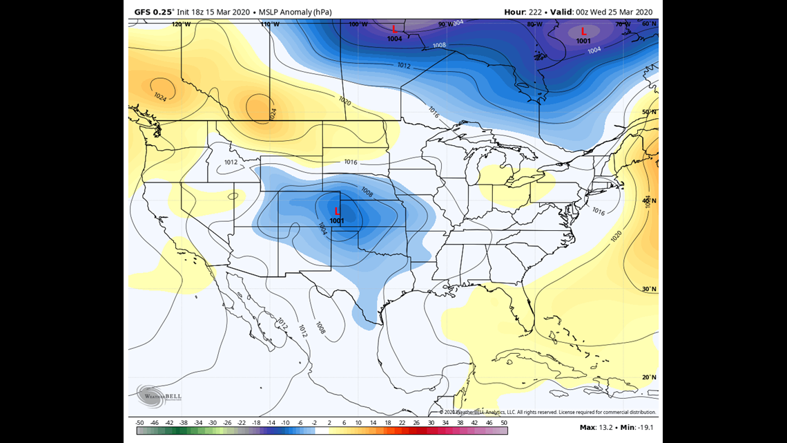
The first part of the state to get hit will be southwestern Colorado. Models are indicating 6-16" in the San Juan mountain passes starting at about noon on Wednesday and lasting into the day on Thursday. The heaviest snow may be overnight. Winter Storm Watches may come out in the next day or two.
The heavy snow will start to hit other parts of the mountains, as well as southeastern Wyoming on Wednesday. Travel through that part of Wyoming might be manageable on Wednesday but Thursday looks like a very dangerous day. High winds and very heavy snowfall rates are likely through the day on Thursday.
Still 4 days to go, but another area of concern would be the foothills of Douglas, Jefferson, Boulder, and Larimer Counties. The Euro has been consistently showing temps cold enough for all snow there with totals in the 10 inch range.
Other parts of the Front Range, Palmer Divide, I-25 corridor, and northeast plains should keep a close eye on this system. Heavy snow will be likely in those areas on Thursday. Early estimates are for 2-4" in the Denver metro area, 3-6" on the Palmer Divide east of the foothills. And 3-6" to the north and east of Denver.
System should clear out before sunrise on Friday, but timing may shift a bit over the next couple days. Just a heads up if you have travel plans on Thursday. Guess since everyone is on quarantine, that might not be a problem. Mountain snow will continue on Friday.
Chance of snow in Denver: 45%
March 21-24
This very active period of weather will continue with another storm immediately after. Actually looks like three more separate surges of cold that may be a little difficult to separate but I'll keep these first two in a group for now.
So far these storms look to be mostly mountain impacts with mixed rain and snow on the Front Range. There is an indication for some of those mixed showers on Sunday and Monday morning.
Chance of snow in Denver: 10%
March 25-28
This storm is not quite in range of the high resolution Euro yet, but the GFS has been consistently showing another storm system with possible impacts to the Front Range here.
Chance of snow in Denver: 0%
March 31
The GFS also shows one more storm on the final day of the month.
-----------
Saturday Update:
March 15-16
A little cold air and moisture remains in some spots. Some freezing rain possible overnight on the Palmer Divide and eastern plains.
Light mountain snow showers tomorrow and Monday.
Chance of snow in Denver: 0%
March 17
A wave of rain and snow likely on the northeast plains. 0-1" of accumulation. Could get a couple drops of rain in the metro area.
Chance of snow in Denver: 0%
March 18-20
Still a good lookin cyclone in today's models but overall weaker and warmer. Position continues to support a big winter storm for southeastern Wyoming and parts of Nebraska.
The first day on Wednesday looks like big snow for the San Juans and other parts of the mountains.
Then on Thursday the storm moves down to the Front Range. Hitting Wyoming hard in the morning, and then the Colorado side in the afternoon.
Numbers are down a tad today. Early estimates are for about 1-4" in the metro area and the Palmer Divide, and 2-4" in the foothills.
Chance of snow in Denver: 25%
March 21-24
Another storm will follow shortly after. Looks like some more decent snow in the mountains but less impact to the Front Range. A mix of rain and snow possible though.
Chance of snow in Denver: 5%
March 26-29
GFS has another storm after the previous 2. Even shows some impact to the Front Range.
-----------
Friday Update:
March 14
Light snow showers remain possible on the northeastern plains and also in the mountains Saturday. Less than an inch of accumulation is expected except maybe in the northern mountains.
March 15-16
A small disturbance could bring some snow showers to parts of the mountains and the far eastern plains. Less than an inch of snow is expected.
Chance of snow in Denver: 0%
March 17-18
Some rain is possible in parts of Colorado. Light snow in the mountains.
Chance of snow in Denver: 0%
March 19-20
This will be the next winter storm to hit the Denver area on. The Euro shows a strong mid-latitude cyclone extending down to the surface.
There is a much better position and colder air with this one. Early estimates are for 2-4" in the metro area, and 3-6" in the foothills and Palmer Divide.
Chance of snow in Denver: 20%
March 21-24
There looks to be another storm right behind the previous one. It has possible impacts to the Front Range, but models are not currently showing snow accumulation with this one.
Chance of snow in Denver: 0%
March 26-29
GFS is still showing yet another storm. No impacts shown to the Front Range yet though.
-----------
Thursday Update:
Mar. 13-14
The split jet stream currently set up over the US, has created a breeding ground for winter storms just off the coast of California. That will give Colorado several chances at getting a major winter storm over the next two weeks.
This first one will not be it.
The weakness in the ridge to the east will not last long enough to keep this next storm strong and on track.
It will be a very wet storm though and bring lots of snow to the southern mountains. A Winter Storm Warning goes from 3am to midnight tomorrow. 8-16 inches of snow will be possible in the San Juans.

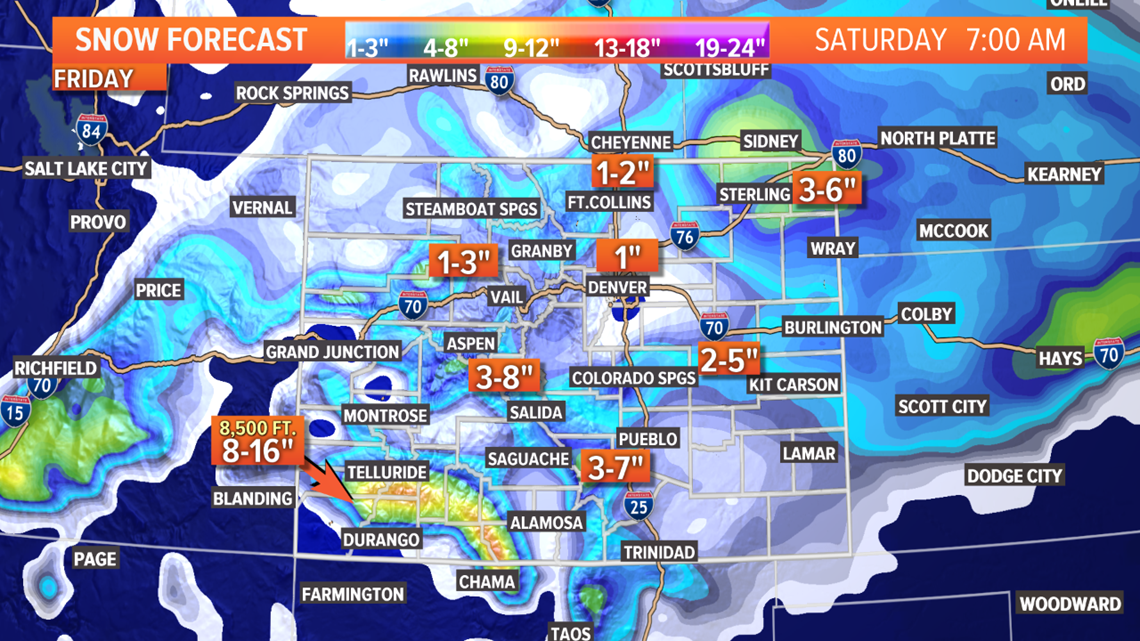
The other alert in Colorado is on the eastern plains where Yuma, Kit Carson, and Cheyenne Counties are under a Winter Weather Advisory from 6a to midnight for 1-4 inches of snow and the possibility for some icing.
There is also a Winter Storm Warning out for central Nebraska for 5-7" of snow from 9am Friday to 6pm Saturday.
There is still a chance to get an advisory for El Paso County where 2-4" of snow is possible, but so far that has not been issued.
And the Denver metro area may only get a quick wave of snow between 9am and noon. Many of us will only see about an hour of snow. That will result in very little snow accumulation and maybe even none for some spots. With temperatures relatively warm, it could be mostly rain as well.
A little better chance of getting more than an inch to the north of Denver.

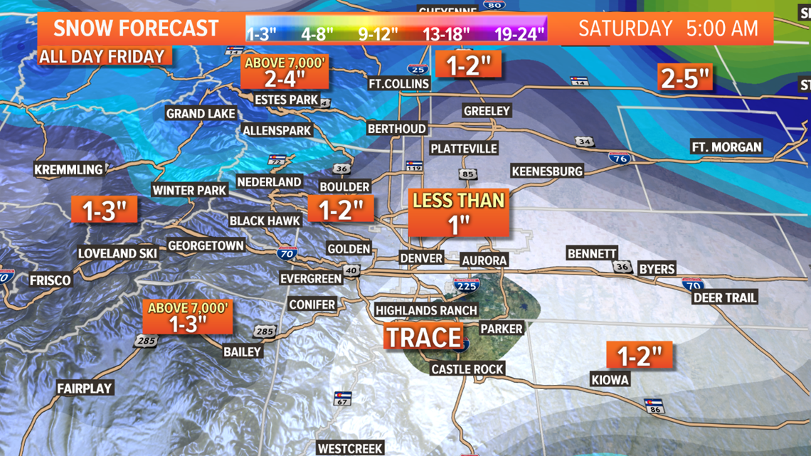
On Saturday morning, the snow showers will continue on the northeast plains and in the mountains. Maybe later in the day as the system exits our region, there could be a few convective showers along the Front Range.
Mar. 15-16
Small disturbance could bring about an inch of snow to the high mountain passes in Colorado.
Chance of snow in Denver: 0%
Mar. 18-20
Models show another weakness in the western ridge next Wednesday allowing another low to move in. So far the organization looks pretty good with this one. Solutions show some snow on the Front Range on Thursday and Friday.
Chance of snow in Denver: 10%
Mar. 21-24
GFS still shows two additional storms back to back with possible impacts to the Front Range.
Chance of snow in Denver: 0%
Mar. 25-27
Second day in a row with the GFS showing a storm with impacts to the Front Range.
-----------
Tuesday Update:
Mar. 11-12
There is a plume of moisture still moving in from the southwest while a trough is moving down from the north. The two will come together over the next couple days to create some more mountain snow showers.
1-4" in most places. Maybe a little more in places up north like Steamboat Springs. No alerts are out for this storm at this point.
Probably will be a few mixed rain and snow showers in the foothills Thursday evening and night. Northeast plains could get some too. Accumulation is possible but likely just less than an inch.
Chance of snow in Denver: 0%
Mar. 13-14
There is a swirling batch of low pressure along the southern jet just of the coast of California. It's been waiting for a chance to move northeast, but strong high pressure over the States has been preventing that.
It looks like that moment will come on Thursday. A slight weakening in the ridge will allow it to start moving our way.
Snow showers will start very early in the morning on Friday in El Paso County stretching east towards the Kansas state line. Those areas around Colorado Springs, Highway 24 to Limon, and on down the I-70 east corridor from there could be looking at 2-5" of snow according to the Euro.
Some gusty winds are likely there as well.
The Denver area could get just enough snow for there to be accumulation. Models show between a half inch to 1 in most spots. Likely the snow will move through the metro in a wave from the south between 8am and 2pm.
Biggest hit from this storm will the San Juans. Numbers are coming down there a bit, but Euro shows 4-8".
Chance of snow in Denver: 35%
Mar. 16-17
It looks like it will be tough to separate the impulses coming off a series of troughs for a few days here, but I'll leave them separate for a few days. There is an increasing chance for snow in the metro area on Tuesday. Euro shows the potential for an inch or two.
Chance of snow in Denver: 5%
Mar. 18-20
These storms are shown as consecutive and carries another chance for snow in the Denver area.
Chance of snow in Denver: 5%
Mar. 21-23
This is the second day for the GFS showing a storm here. Not in range of the 10-day Euro yet though.
Mar. 24-26
GFS switched this period back to stormy in Colorado.
-----------
Monday Update:
Mar. 10
Some light mountains snow showers during the day Tuesday. Less than 2 inches during the 24 hours period. A few light and quick showers will be possible on the plains, but those will be quick and very scattered.
Chance of snow in Denver: 0%
Mar. 11-12
Another system sweeps by from the north. 1-4" of snow possible across the most of mountains. Some of the northern mountains could get 3-6".
There will be a chance for some showers across the Front Range as well. Models show some mixed rain and snow showers in the northern plains from Ft. Collins to Julesburg on Thursday night. Less than an inch of snow in that mix.
Chance of snow in Denver: 0%
Mar. 13-14
This next storm system moves in at about 7am on Friday morning. There will even be some snow on the Front Range and Denver area.
San Juan mountains would get the most snow with about 6-12" possible.
Some parts the I-25 south corridor from Colorado Springs to the New Mexico could get some heavy snow squalls with strong winds. Same goes for parts of the southeastern plains.

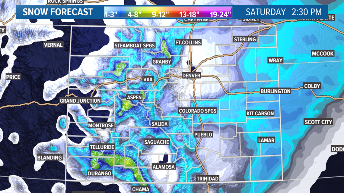
Then as the system moves out late Friday night into Saturday morning, the northeast plains could get some heavy squalls.
This is not a good position to bring a lot of snow to the Denver area or most of the Front Range, but there should be snow showers for most of the day Friday. Models are indicating that there will be accumulation between a half inch to 2".
Palmer Divide is still a wild card in the models. Likely just impacting the southern part of the area along Highway 24.
The system will be battling high pressure and will mostly be just an upper level disturbance.
Chance of snow in Denver: 30%
Mar. 14-15
This trailing storm did not show in todays models. Might drop this solution soon.
Chance of snow in Denver: 0%
Mar. 17
Weak and fast moving disturbance bringing light mountain snow, and could bring a mix of rain and snow to the foothills, and some light rain to the Denver metro.
Chance of snow in Denver: 0%
Mar. 18-20
This will probably be Denver's next chance to get snow accumulation. So far the Euro does not show that, but it does have some snow accumulation in the area.
Chance of snow in Denver: 0%
Mar. 21-23
And another switch here by the GFS. Back to a storm in Colorado.
Mar. 24-25
Clear in this window.
-----------
Sunday Update:
March 9
Rain and mixed showers continue on the Front Range overnight. Could see some convective type storm late into the night. Only snow accumulation showing in the models is on the Palmer Divide around Monument Hill and parts of the foothills, but even that is less than a quarter inch.
Rain totals should be very decent for much of the area, especially the eastern plains. Some spots could get about a quarter inch of rain.
Not much action during the day tomorrow except a few light mountain snow showers.
Chance of snow in Denver: 0%
Mar. 10
A few light mountain snow showers Tuesday. There will be a slight chance to get a little rain on the Front Range, but most of that will just evaporate before hitting the ground. Probably less that 5 percent of northeast Colorado will get any measurable rain.
Chance of snow in Denver: 0%
Mar. 12
The March 12 system is really separate even though it will kind of blend into the next storm. Mostly just some light mountain snow showers.
Chance of snow in Denver: 0%
Mar. 13
This storm has shown a signal for a very impactful storm 3 days in a row now. It will have to battle a strong ridge to the east, but could deliver big snow totals and strong winds to the southeastern plains of Colorado.
It doesn't look like much of a surface low but 700 mb organization could kick the winds up strong at times.
San Juan mountains could get some good snow as well.
There has also been a indication for snow on the Front Range on Friday as well. Models have shown from 1-3". Downsloping winds and warm temperatures will be an issue for snow accumulation in the Denver area.
Chance of snow in Denver: 25%
Mar. 14-15
Possible trailing storm right after with no impact to the Front Range.
Chance of snow in Denver: 0%
Mar. 16-17
This solution will likely change again in the next 2 days as a trough dives down the west coast. GFS has an impact on these days but the Euro does not.
Chance of snow in Denver: 0%
Mar. 18-20
This may end up being our next shot at snow on the Front Range if it doesn't split in half. GFS does already indicate an impact though.
Chance of snow in Denver: 0%
Mar. 21-24
And this period flipped again in the GFS. Now showing clear again.
-----------
Saturday Update:
March 8-9
Scattered snow and rain showers have appeared in western Colorado tonight. Even a decent thunderstorm near Bayfield. And some thundersnow reported near Pagosa Springs.
There are no weather alerts in Colorado for this system though.
Look for rain and snow showers in the Front Range mountains and foothills a little after noon tomorrow. Then the rain will move down onto the I-25 corridor and eastern plains.
I wouldn't expect too much action along the I-25 corridor as the storms will be scattered and short lived. Very Spring-mode. Maybe a better chance after dark.. even after the time chance.
The northeast plains have the best chance to get decent rain showers along with some sleet, graupel, hail, and whatever. Some areas could get up to a quarter inch of rain.
This system will be clear of the Front Range before sunrise on Monday, but some light snow showers will continue in the mountains.
Chance of snow in Denver: 0%
Mar. 10
System moving to the north of Colorado will bring some light mountain snow showers and maybe a little rain to parts of the foothills.
Chance of snow in Denver: 0%
Mar. 12-14
Our storm chances on the Front Range will really start to increase for maybe about a week starting with southern system,
The Euro is painting a picture with the storm containing a high amount of moisture. This would be the San Juan mountain range could get hit very hard. Model is showing 10-18" in a very short amount of time. Probably see the return of winter weather alerts to our state.
This would also mean a lot of snow in eastern Colorado along with some powerful winds. Maybe even close to blizzard conditions. This would favor the southeast plains but could involve some of the central and northern plains as well.
Also still showing a decent chance for some good snow on the Palmer Divide, but with temperature issues and dry winds coming from the southeast over the Palmer Divide, this would not be a good scenario for much snow in Denver.
However snow accumulation in Denver on Friday night is likely at this point. Just not much.
Chance of snow in Denver: 20%
Mar. 14-15
Timing has changed a bit with this system but it is still showing in the models. Light impacts possible on the Front Range.
Chance of snow in Denver: 5%
Mar. 16-17
This is a new solution for the GFS and the Euro. Mostly mountain impacts but snow might be possible on the Front Range as well.
Chance of snow in Denver: 0%
Mar. 18-19
GFS has this system in it's solutions again today. Again with some snow possible on the Front Range.
Mar. 20-22
And today the GFS switched back to showing some mountain snow here.
-----------
Friday Update:
March 7-9
It's spring in Colorado. That means our storms can produce snow, rain, hail, graupel, sleet, lightning, and YES Thundersnow!
This is that kind of system. We should see all of the above.
The snow accumulation will not be too impressive. There are no advisories in the state at this time, but it looks like 3-6" will be possible on the mountain passes. Favoring the southern San Juans.

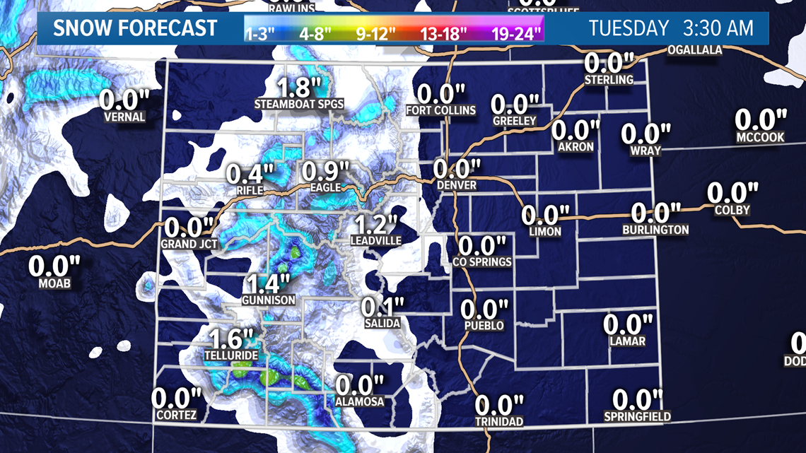
The interesting storm cells I mentioned above will start popping on the Front Range on Sunday afternoon. Some of us might get skipped, that is the nature of convective type storms.
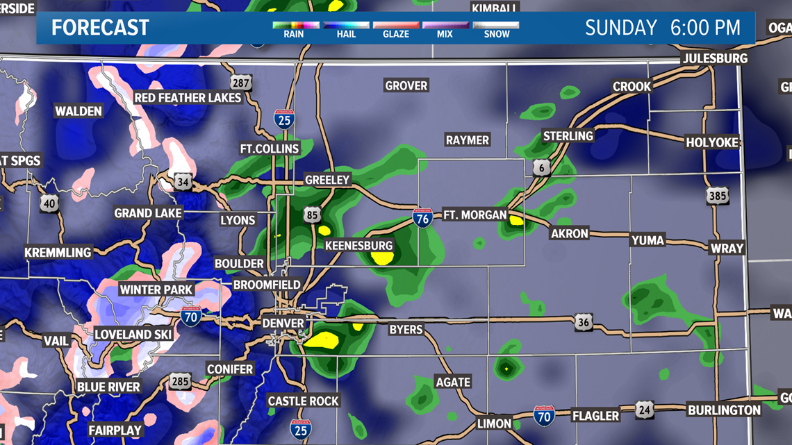
First rain may be pretty light, and might not even reach the ground through the dry air, but they should start to populate before too long. NAM shows some of the heavier cells around 6pm, but still very small and scattered.

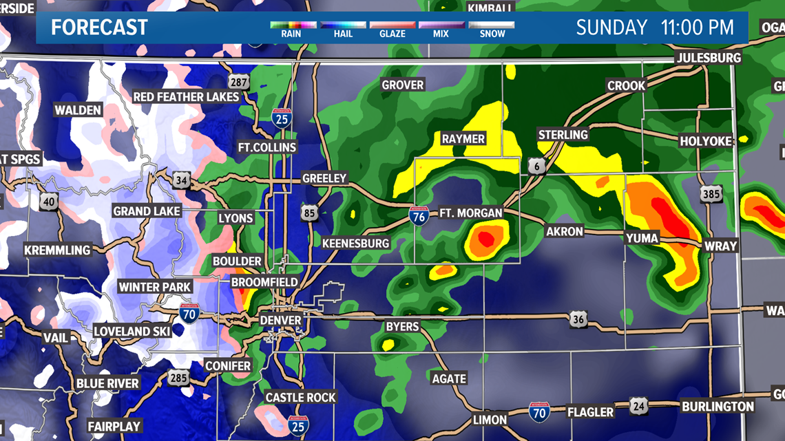
Then as the night progresses the storm may grow stronger. The NAM indicates some heavy cells on the plains late Sunday night. These could even be thunderstorms.

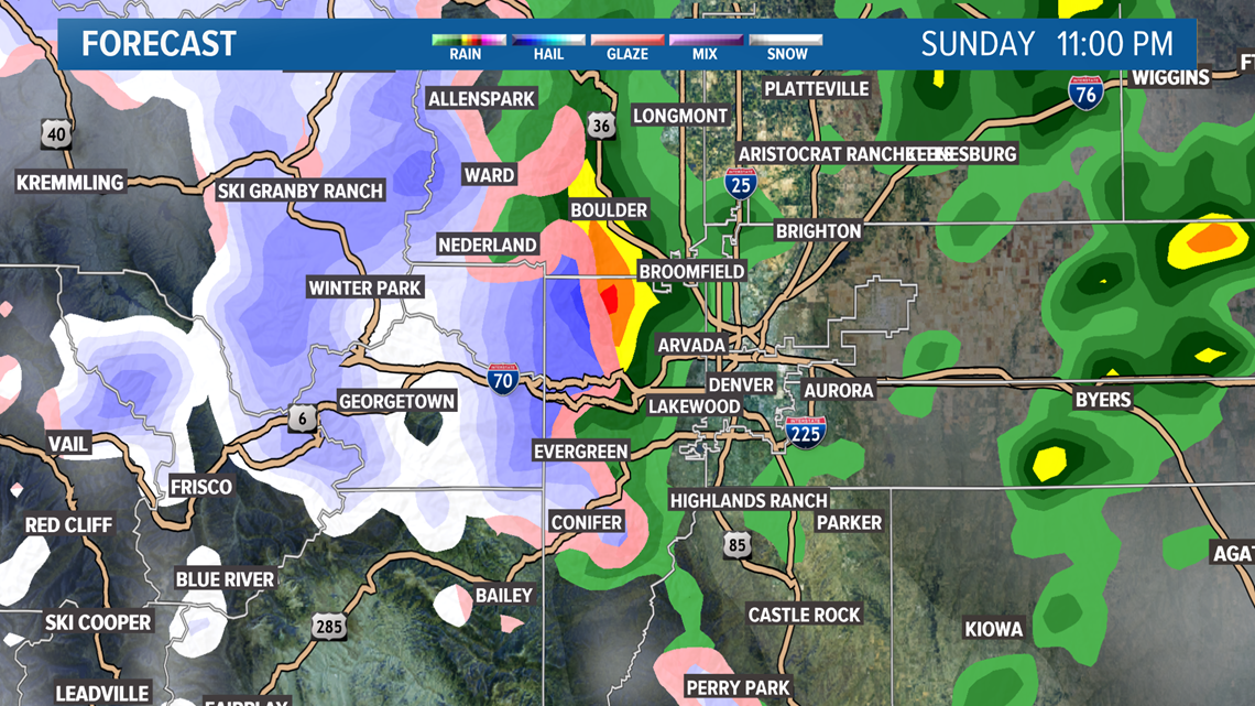
The mixed precip storm cells will be possible in the metro, foothills, and Palmer Divide at any time Sunday evening, and lasting late into the night.

Chance of snow in Denver: 0%
Mar. 10-11
The next series of storm systems are hard to separate because they are overlapping from the north and south.
Mostly just light mountain snow with this system, but a few light rain showers might be possible on the Front Range as well.
Chance of snow in Denver: 0%
Mar. 12-14
This storm system is shaping up to be a very potent and organized southern tacking system. Likely very high amounts of moisture, but it appears there may be a temperature issue on the Front Range when it comes to snow production.
We'll have to keep an eye on this one because it's the strongest system the models have shown in a while, and there's a good chance for major impacts somewhere in Colorado.
For now, the models are showing mostly a rain snow mix for the Denver area with 1-3 inches of accumulation in the southern suburbs. The current Euro solution show high snow potential for the southern foothills and the Pikes Peak region.
Probably don't need to remind anyone the last year March 13th was a Friday as well, and we got a wee bit of a blizzard.
Chance of snow in Denver: 10%
Mar. 14-15
Timing has changed a bit with this system but it is still showing in the models. Light impacts possible on the Front Range.
Chance of snow in Denver: 5%
Mar. 18-19
GFS shows another storm with possible impacts to the Front Range. Second day showing this system.
Mar. 20-22
This window is clear today, which is strange for me because I start my vacation on the 21st. Usually I curse the Front Range with a bad storm when I leave.
-----------
Thursday Update:
March 7-9
A small storm system will eventually be able to penetrate a strong ridge that has been building around Colorado. This will happen on Saturday afternoon.
4-8" of snow will be possible on some of the high mountain passes. Mostly favoring the southern and central areas.
Mountain travel will get slick, especially on Sunday.

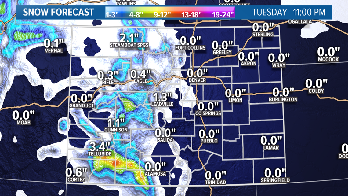
A few light rain showers should move onto the Front Range by about 2 or 3pm on Sunday and then get even heavier between 6 and 10pm. It is possible for them to change to some flakes or a mix at night, but it is most likely that it will stay just rain.

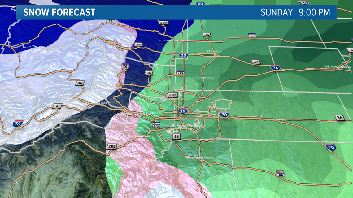
Foothills and Palmer Divide areas have a better chance of seeing some snow mixed in, but accumulation is unlikely.
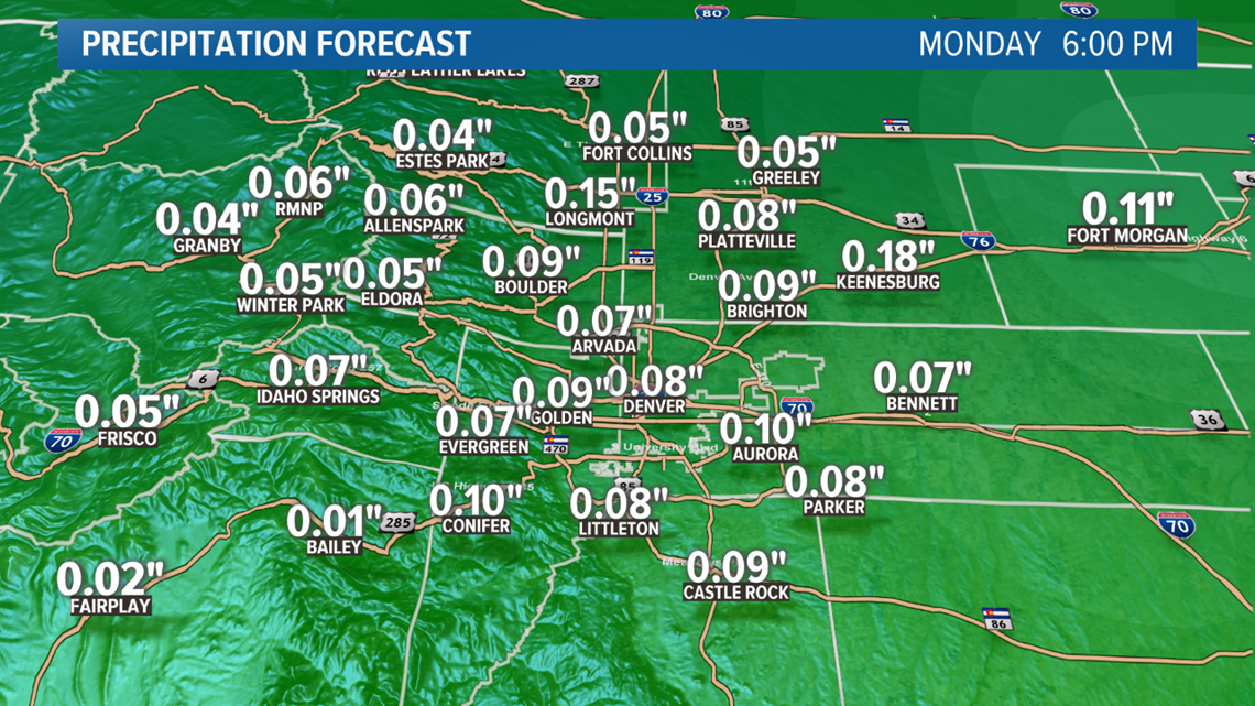
Not everyone will get rain, but some spots could get some decent totals close to a tenth of an inch on the Front Range, and maybe even a quarter inch in the northeast corner.
Chance of snow in Denver: 0%

Mar. 10-12
System split to the north and south. Could be a little bit heavier snow for the mountains this time, but again just rain and maybe a mix on the Front Range.
Rain chances will be much lower with this system.
Chance of snow in Denver: 0%
Mar. 13-14
Euro shows a combo of a southern storm an a western trough working its way down the west coast.
Still just mountain snow showing though.
Chance of snow in Denver: 0%
Mar. 15-16
Models continue to show the ridging in the middle of the country mostly keeping the storm surges at bay. Some mountain snow shown here as another trough moves down the west coast.
Chance of snow in Denver: 0%
Mar. 17-21
GFS flipped back into storm mode in this window today. A complete reversal from yesterday.
-----------
Wednesday Update:
March 5
Little bit of a cold front pushing through. Not much precip is expected with it though. Maybe some snow showers on the high mountain peaks, and parts of southern Wyoming but nothing much.
Chance of snow in Denver: 0%
March 7-9
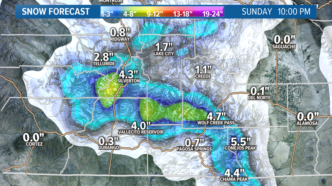
A storm system moving across the southern part of the state will start to bring snow showers back to the high country on Saturday afternoon and last through the day on Sunday.
Numbers have been coming down a tad in today's modeling but 4-8" looks pretty doable in the southwest mountains.

There should be snow in the res of the state as well, but temps will likely be too warm on the Front Range and eastern plains for snow accumulation.

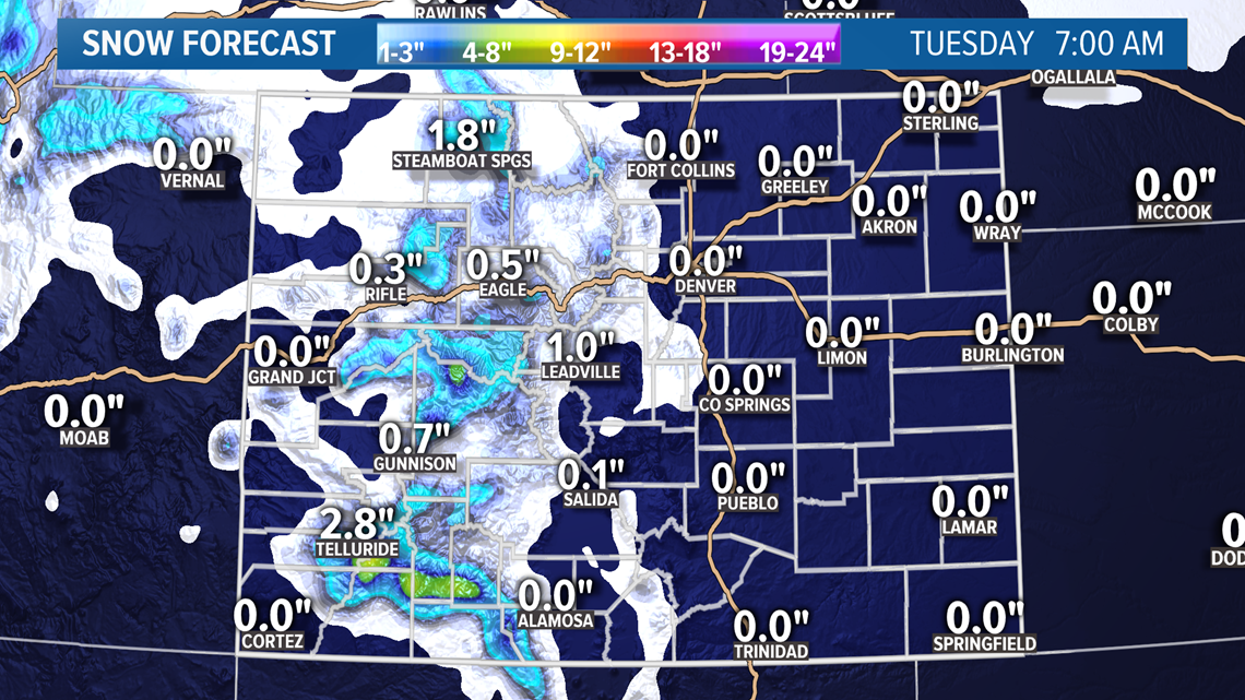
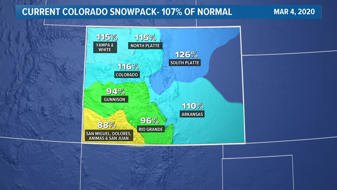
There has been a lengthy snow drought in the southern part of the state now dropping well below average for snowpack. High numbers in the north though, are keeping the statewide number just above average.

There will be some rain showers developing on the Front Range and eastern plains sometime after noon on Sunday. Those showers could transition to a mix of snow later than night into Monday morning, but snow accumulation still looks very unlikely.
Rain could be heaviest on the northeast plains.
Chance of snow in Denver: 0%
Mar. 10-12
I am combining these two little piece of cold air spinning in the same northern vortex. Could be some heavy mountain snow again with this one but temps will probably be too warm again on the Front Range for snow.
Models do show some rain down low but with less of a chance than the previous system.
Chance of snow in Denver: 0%
Mar. 13-14
Euro shows a combo of a southern storm an a western trough working its way down the west coast.
Still just mountain snow showing though.
Chance of snow in Denver: 0%
Mar. 15-16
The GFS shows a return of cold Canadian air with a storm system diving straight down from the polar regions. This is a new solution today.
Mar. 17-20
In today's runs, the GFS shows clearing under a western ridge in this time frame.
-----------
Tuesday Update:
March 5
This storm system will move through the Dakota's but it will drag a weak and dry cold front across our area on Thursday morning. Doesn't look like there will be any precipitation in the state of Colorado.
Chance of snow in Denver: 0%
March 7-9
This is a fairly weak storm on the southern branch of the jet stream, but it should move right through the wheelhouse for snow in the southern and central mountains.
Looks like 5-10 inches will be possible on some of the mountain passes.
This will also bring a chance for some snow on the Front Range on Sunday night into Monday morning, but the temperatures will likely be too warm for any snow accumulation in the metro.
I could see some foothills locations and maybe Palmer Divide getting a little accumulation.
Even thought the chances for snow accumulation looks quite low, the overall precipitation numbers aren't too bad. As much as a quarter of an inch of rain possible in the metro and eastern plains.
Chance of snow in Denver: 0%
Mar. 10
A northern storm track will bring some light snow to the mountains. Some light mixed snow and rain showers possible on the plains and Front Range but snow accumulation looks unlikely.
Chance of snow in Denver: 0%
Mar. 12-13
There still is not much clarity on this time period but there is definetely a signal of a pattern switch where the Front Range should get a few nice chances at snow in the middle of March.
Chance of snow in Denver: 0%
Mar. 15-16
Some impacts to the Front Range possible.
Mar. 17-18
Good signal coming from the GFS but its the first day showing on this date.
-----------
Monday Update:
March 3
Colorado will be trapped in between the jet to the north and a cutoff low to the south. That will bring dry downsloping air to the Front Range. Warm temps and mostly clear skies.
Chance of snow in Denver: 0%
March 5
A storm system moving by to the north of Colorado will have little impact other than an early morning cold front. No precipitation will likely fall anywhere in the state.
Chance of snow in Denver: 0%
March 7-9
Southern storm track looks like a good hit for the southern mountains. Models showing 6-12" which would bring out a winter storm warning for the San Juan mountain passes.
This will also be the chance for snow on the Front Range, although no accumulation was indicated in today's modeling. The models have been showing temps mostly in the 40's so it will likely be all rain on Sunday and Monday.
Chance of snow in Denver: 0%
Mar. 10
A northern storm track will bring some more snow to the mountains. The Euro shows about an inch of snow on the northeast plains but none on the Front Range.
Chance of snow in Denver: 0%
Mar. 13
The GFS has been showing a mountain storm with some impacts to the Front Range possible. This will be in range of the 10-day Euro tomorrow, so we may get a better feel for this one.
Chance of snow in Denver: 0%
Mar. 15-16
A southern storm track showing very close to impact on Colorado.
Mar. 17-18
Mostly just a mountain storm showing so far.
-----------
Sunday Update:
March 2
Snow will continue overnight. Some areas could easily get another inch of snow after midnight. There could still be a few light snow showers around at sunrise but it will be over shortly thereafter.
Temps will drop down to about 24 degrees in the Denver area by 6am, so there will be icy spots on the streets. Expect the morning commute to be slower than normal.
March 3
No snow showers expected in Colorado on Tuesday morning.
Chance of snow in Denver: 0%
March 5
This storm will be too far to the north east of Colorado to impact our state.
Chance of snow in Denver: 0%
March 7-8
This southern tracking storm still looks very good for the San Juans, and it will also bring the next shot of snow for the Denver area on Sunday night. It looks like a very low chance of even picking up an inch of snow though.
Chance of snow in Denver: 0%
Mar. 9-10
Then a storm on the northern branch of the jet stream. This will favor the northern mountains and may also bring a chance for snow on the Front Range. At this point, there is no accumulation indicated though.
Chance of snow in Denver: 0%
Mar. 12-13
Heavy mountain storm showing here, but still no impact to the Denver area.
Mar. 15-16
Still a snow signal with this storm for the Denver area showing snow on Sunday March 15.
Mar. 17
Could go through a little active stretch here with the GFS showing another storm with possible impacts to the Front Range.
--------
Saturday Update:
March 1-2
Snow tomorrow night and Monday morning on the Front Range. Could be some rain initially but I wouldn't expect to see much of that hit the ground. Most areas will likely go straight to snow. No advisories issued for this storm as of 5pm Saturday because travel is not expected to be much of an issue.
2-7am - Scattered and light snow showers west of the Continental Divide. About an inch on some of the mountain passes by 7am.

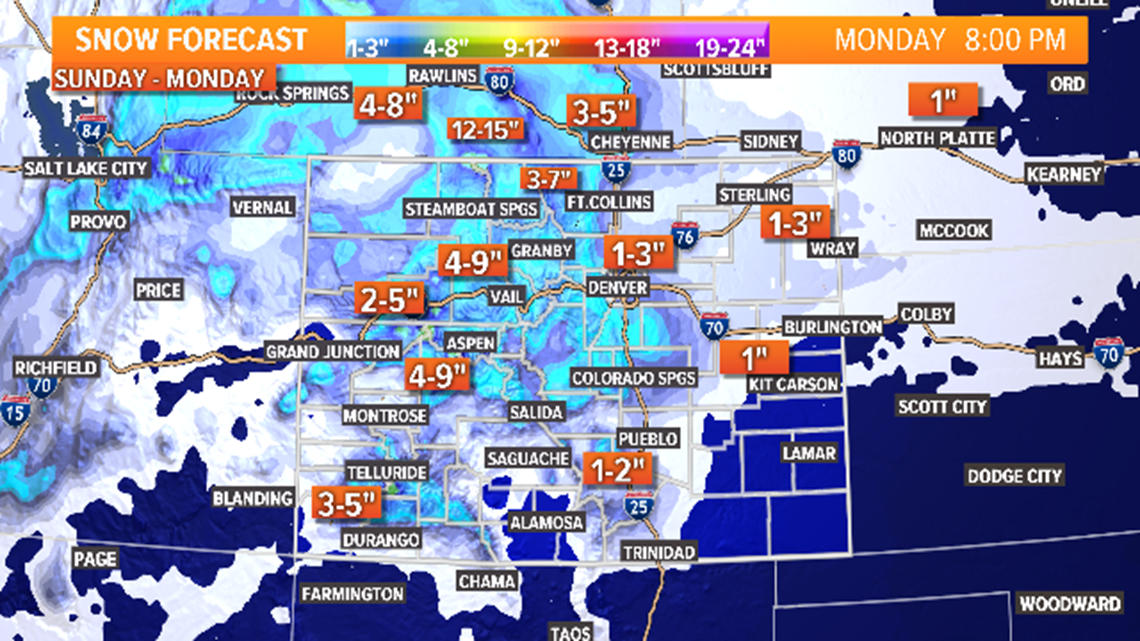
8am - First snow on the Front Range in the Larimer County Foothills, Cheyenne, and Laramie.
11am - First snow on the I-70 mountains corridor.

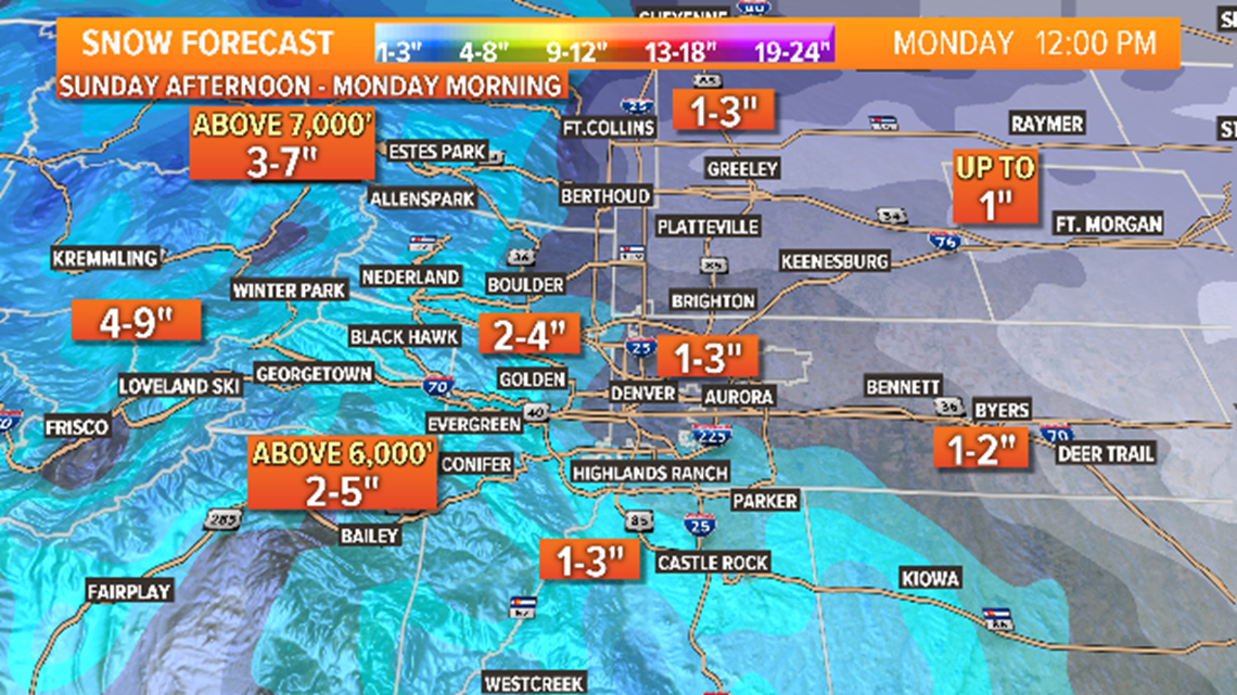
12pm - First accumulation in Ft. Collins area.
1pm - First snow in the Denver metro area.

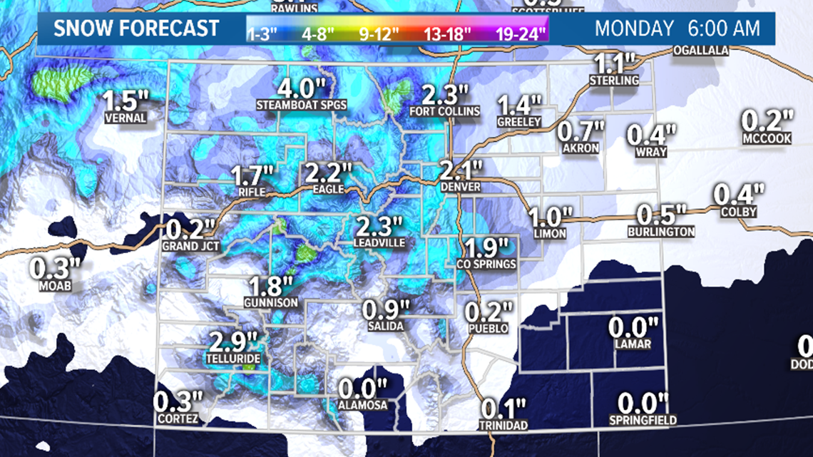
3pm - First accumulation in Denver and Colorado Springs, and Palmer Divide.
5-11pm - Heaviest snow in the Denver metro area. Just light snow after midnight.
6am - Storm is over. 1-4" of snow in the Denver metro. Coldest temperatures are from 3-7am in the Denver area so icing is likely. With that being the lightest period of snow though, travel will not be too bad. Commute likely slower than normal.
March 3
There is another patch of cold air swirling around the edge of the previous storm, but not much impact is expected with this one. Scattered snow showers possible along the northern Colorado state line. Snow accumulation is not expected.
Chance of snow in Denver: 2%
March 5
A little snow possible in southern Wyoming with this storm but not much. No impact to the Front Ragne.
Chance of snow in Denver: 0%
March 7-8
Pretty weak system but well place for the southern mountains. Models have been consistently showing some good numbers down there with this storm. Impacts to the Front Range are unlikely.
Chance of snow in Denver: 0%
Mar. 9-10
GFS was showing a weak signal here for a while, but has dropped it. The Euro does not show anything either, so probably cut this one out tomorrow.
Mar. 12-13
Mountain storm showing here again today, but no impacts to the Front Range.
Mar. 15-16
This remains the next strongest signal after March 1. GFS shows snow in the Denver area on Sunday Mar. 15.
--------
Friday Update:
March 1-2
We are on track for our first snow storm of March to come in on the very first day. The storm is even trending faster in today's modeling which means the temps won't get as high and and we could get more snow instead of rain.
That really doesn't change the spread for the Front Range though. That stays at 1-4".


There are no advisories in Colorado yet, but a few might be possible in parts of the mountains. Not a huge storm, but 3-6" is likely on most of the mountain passes.
The heaviest snow will be in the northern mountains where 6-10" are possible in spots near Cameron Pass.
Our snowpack in the South Platte River Basin stands at 30% above average today, and this storm should be enough to keep us at the pace.

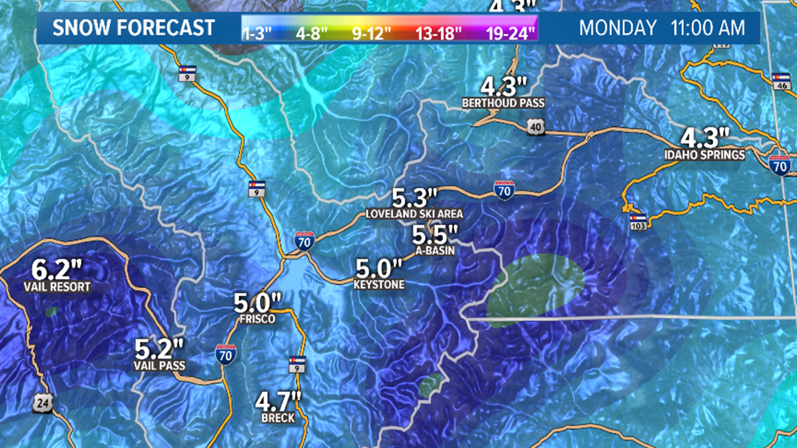
On the Front Range, it looks like there could be some rain, snow, and mixed showers starting up after noon and lasting to about 5pm before the heavier and more widespread snow sets in.
Snowfall in the Denver metro could be very heavy after sunset, but with all the heat stored in the roads over the previous 3 days, even the heavy snow is likely to melt on the roads initially.
The foothills have been trending down a bit in snow but a few places could still get more than 4 inches.
It will likely turn to snow earlier to the north of the Denver area because the front is coming from the north.

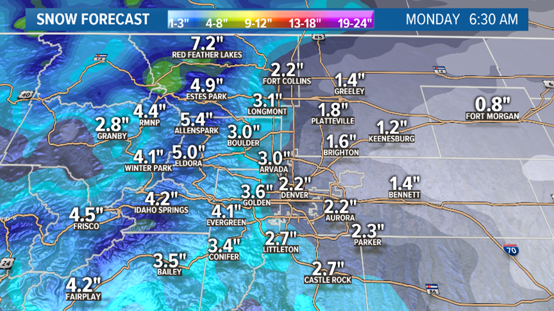
The heaviest snow on the Front Range will probably fall from about 6pm to midnight on Sunday but continue into the morning on Monday. The front will be pretty powerful especially compared to our last one. Temps could even get down into the teens by the time it stops snowing. That means that there will likely be icy roads by the time the morning commute starts up. Lighter snowfall at the time will help it from becoming a complete mess though.
Snow should be light, broken, and scattered by about 6am, and cleared out of the area by 9am.
Chance of snow in Denver: 90%
March 3
There is another surge of cold air behind that storm, but it appears it will be very dry for Colorado.
The models have been showing less and less of those scattered snow showers on Tuesday, so the chance of seeing a few more flakes in Denver is going down.
The light snow in the mountains on Tuesday and Wednesday have been trending lighter as well. It now looks like less than an inch possible.
Chance of snow in Denver: 10%
March 7-8
This could bring some decent snow to parts of the mountains, especially to the south, but models are still showing only downsloping dry air east of the Continental Divide.
Chance of snow in Denver: 0%
Mar. 9-10
Some mountain snow showing with this storm, but no impact on the Front Range is indicated yet.
Mar. 12-13
The overall jet stream pattern stays active but just not strong enough or close enough to impact Colorado too much. This storm looks to have little impact, although on about every 4 or 5 runs, the GFS produces snow on the Front Range with this storm.
The most recent solution does not however.
Mar. 15
This signal for this storm is the strongest one after the March 1 storm. Still a ways out but the GFS is indicating some impacts to the Front Range.
--------
Thursday Update:
March 1-2
March 1 is the first day of spring in meteorology and it appears we will be dealing with spring-like issues with another winter storm. Mainly that means relatively warm temperatures.
Our first storm of the month moves in though, on the first day of the month very early in the morning on Sunday. It appears that it will mostly impact the southern and central mountains.
Expect at least winter weather advisories for Sunday and Monday with the heaviest snow starting late Sunday night into Monday morning.
The storm moves out onto the Front Range on Sunday a little later in the day. It may even reach daytime highs in the upper 50's before the storm takes hold.
So that means rain is likely at first sometime in the afternoon, or some snow showers that melt immediately on contact with the warm ground. Then after sunset, it looks like snow will start to have a chance to accumulate in yards, rooftops, and sidewalks.
Even though there is a good chance for some very heavy snowfall, I wouldn't expect snow to stick to the roads until after midnight. The Euro current shows the snow going until about 11 a.m. on Monday, so there may be some potential for a slow commute that morning.

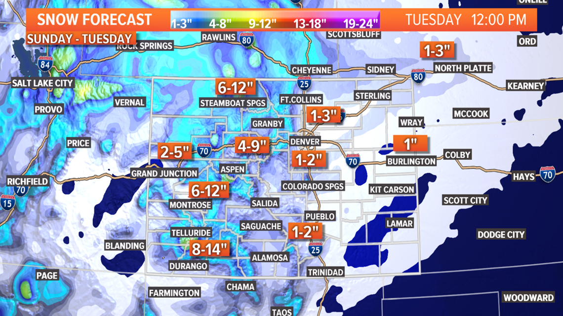
So far, with all the melting, models are only showing about 1-4 inches across the I-25 corridor, and 3-6 inches in some of the foothills.
Chance of snow in Denver: 60%
RELATED: Is February the new March?
March 3-4
Another storm moves past the state right after but it seems like it will have less impact. Models show scattered snow showers on the Front Range on Tuesday afternoon and evening with a few spots getting a half-inch to an inch of snow.
It also shows 2-4 inches of snow in parts of the central and northern mountains with snow ending early on Wednesday.
Chance of snow in Denver: 20%
March 7-8
Wintery storm possible in this window, but at this time it only appears that light mountain snow showers will be possible.
Chance of snow in Denver: 0%
Mar. 9-10
Possible storm signal showing here but appears to be pretty weak, with little impact to the Front Range.
Mar. 15
Quite a bit of ridging showing in the models from Mar. 4-15 but a weak storm signal is showing for this day. If the storm on the first day of March doesn't come through, we may have to wait until about Mar. 17-20 to get our first good storm chance of the month.
SUGGESTED VIDEOS | Science is cool


