COLORADO, USA — April will finish below average for snowfall in Denver for the 4th year in a row with just 3.9" measured at Denver International Airport.
A 25 day stretch of active weather in Colorado will now end with a strong ridge of high pressure. That will bring 80 degree temperatures to Denver for the first time this year, which is just a little past the average date of April 22.
There is even a shot at our first 90 degree day before the end of April.
There are not many snow chances showing in the modeling for Denver over the next few weeks, but the second week of May is notorious for snow accumulation. There is a slight blip showing long range, so lets see if we can make that happen.
If not, the 1.9" measured back on April 16, would be the earliest final snow in Denver since 2007.
This will be the last update on this snow blog, but I might start one up for May 1 as there are a couple storm chances coming in the first 10 days of that month.
RELATED: Denver weather forecast
Saturday update (last entry)
April 26
A weak impulse moves across the state on Sunday bringing scattered mix showers to the high country with little accumulation.
There will be a wave of afternoon and evening showers on the plains and the Front Range as well, but just rain.
Chance of snow in Denver: 0%
April 28
Just a few scattered showers across the state here as this storm will be well to the north of Colorado.
Chance of snow in Denver: 0%
May 1-2
The strong ridge starts to allow a little more action stormwise in Colorado. This does not look to be a very cold storm. Maybe a few thunderstorms though.
Chance of snow in Denver: 0%
May 3-5
This is the next signal to watch for snow in the Denver metro. Models show a nice system digging quickly in from the northwest. The Euro shows a little snow accumulation on the 4-5th.
Chance of snow in Denver: 5%
May 9-11
There is another storm signal showing here on the GFS.
--------
Thursday update (April 23)
April 24-25
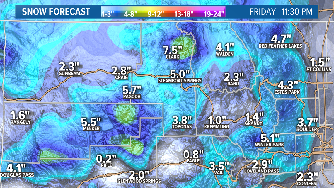
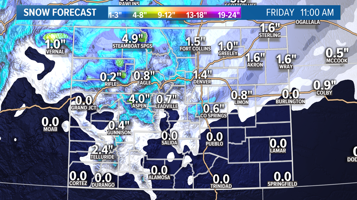
The showers in the Denver area tonight and the rest of the eastern plains should remain as mostly rain, but by the morning hours, it could transition to some mixed snow.
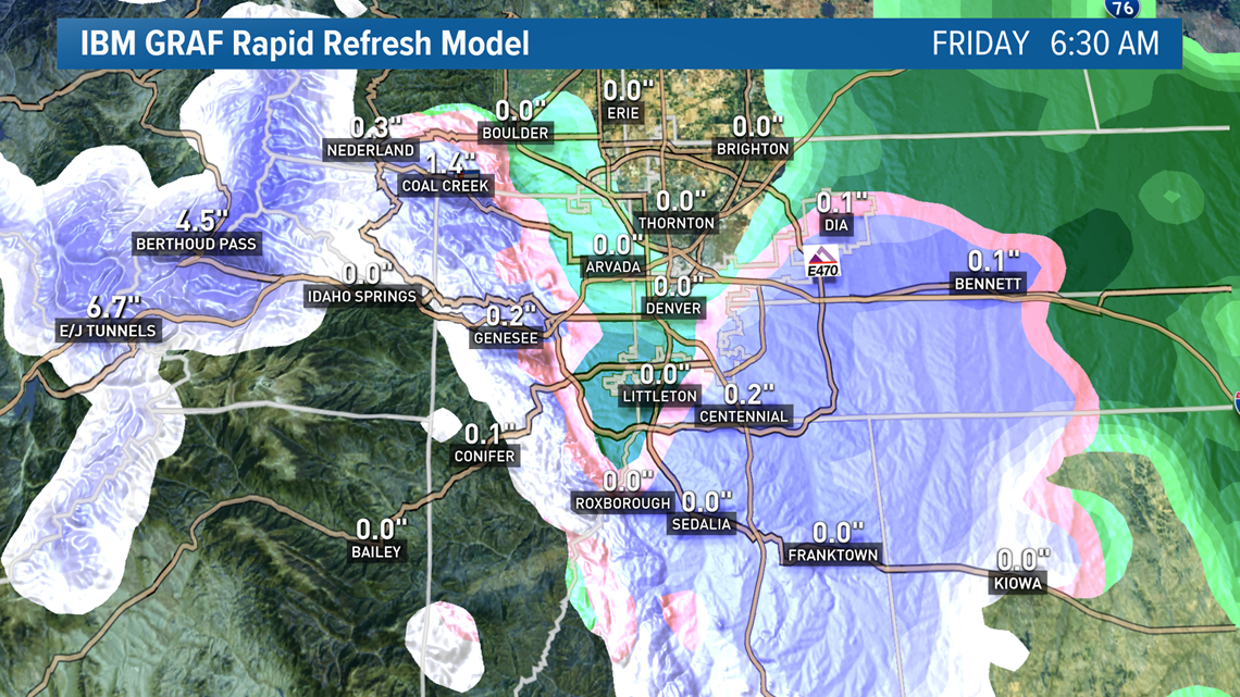
This snapshot from the IBM GRAF model at 6:30 am Friday morning, shows part of the area switching to snow with even a slight bit of accumulation. I have found the characterization of storms pretty accurate with this new model so far, but it has not done well with accumulation yet. So I think those numbers in the mountains may be overdone by about 50%.

The morning temps in the metro will likely be in the mid to upper 30's so if there is some accumulation from these mixed showers, it will likely be brief.
Then more showers along the Front Range and eastern plains on Friday afternoon. Those will likely remain as rain and Thunderstorms.

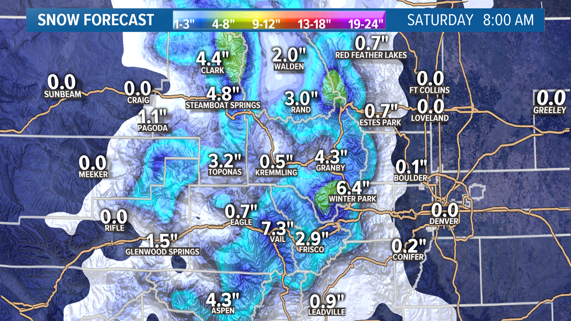
The timing could be right for more showers on Saturday morning, in the Denver area, to switch over to snow. Models are showing a chance for some light accumulation in the Denver area.
This system clears out on Saturday afternoon.
Chance of snow in Denver: 10%
April 26
This system moves through quickly on Sunday. Looks like a few mixed showers possible in the mountains with little snow accumulation.
Light rain will be possible at the lower elevations, but no snow.
Chance of snow in Denver: 0%
April 27-28
Adding this system back in because it has been trending a little closer to Colorado. This will bring some possible mountain snow showers with likely less than an inch of accumulation.
Just rain probably on the plains.
Chance of snow in Denver: 0%
May 3-4
The GFS still has this signal on the 5th, but since the Euro shows it a little earlier, I'll switch the days for now. Not that it really means much because it is not a very strong snow signal anyways.
Chance of snow in Denver: 0%
May 8-9
GFS no longer shows an organized signal here. This is May's magic week, so we'll have to see if it makes a comeback.
--------
Tuesday update (April 21)
April 21-22
The rain and snow showers continue in southern Colorado into Wednesday morning. They take a short break, and then redevelop in the afternoon.
The showers will have far less coverage Wednesday.
Chance of snow in Denver: 0%
Wednesday update (April 22)
April 23-25
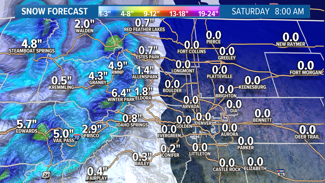
A surge of colder air will be coming from the north over the next few days bringing some snow to the mountains and some mixed stuff down low.
A Winter Weather Advisory will go into effect tomorrow in some mountain ranges west of the Divide.

The showers on the Front Range on Thursday will likely be rain and scattered in nature.
Then on Friday morning, there will be more widespread coverage in the showers on the Front Range. Might see some snow in there in places but not much in the way of accumulation.

Chance of snow in Denver: 2%
April 26
A wave of mountain snow showers moves through on Sunday but just some rain on the Front Range.
Chance of snow in Denver: 0%
May 5
Signal showing some mountain snow showers but very light.
May 7-8
In today's runs, the GFS showed an organized system with arctic air cold enough for widespread snow across much of Colorado. Something to watch, as many know we usually get one shot at snow in the Denver area in May. But this is just the first day for this system to appear in the modeling.
--------
Tuesday update (April 21)
April 21-22
The rain and snow showers continue in southern Colorado into Wednesday morning. They take a short break, and then redevelop in the afternoon.
The showers will have far less coverage Wednesday.
Chance of snow in Denver: 0%
April 23-25
Colder air from the north moves into the state starting on Thursday.
Should be about 1-5" of fresh snow in the mountains by Saturday morning.
The showers make it to the Front Range mostly as rain on Thursday night, but could become a mix of snow by Friday morning. Models are still showing a dusting of less than a half inch in spots around the Denver area.
Chance of snow in Denver: 10%
April 26-27
Scattered light showers around the area. Probably just rain.
Chance of snow in Denver: 0%
May 4
Signal showing some mountain snow showers but very light.
May 7
Weak signal for light mountain snow.
--------
Monday update (April 20)
April 21-22
The next system to impact Colorado will be a very organized southern low. It will more snow to the mountains, mostly to the south.
For the Front Range it will mostly be some scattered thunderstorms except for the area around Pikes Peak that could have some snow in them.
Chance of snow in Denver: 0%
April 23-25
This storm system is coming from the north which means colder air, and snow for the northern mountains. Could even be significant snow along the I-70 mountain corridor.
On the Front Range, there will likely be enough snow in these storms on Friday morning to bring some snow accumulation to the Denver metro area. Probably now all of us will see snow, but some parts could even get more than a half inch.
With lows near 34 degrees the snow will likely only last a few hours. The city and DIA are less likely to get accumulation than the south and west parts of the metro.
May be able to get 1-3" in the foothills.
Chance of snow in Denver: 10%
April 26-27
This little thing may be a little too far north to impact Colorado in the way of snow.
Chance of snow in Denver: 0%
May 3-4
Signal showing some mountain snow showers.
May 6
Mountain snow in this signal.
---------
Sunday update (April 19)
April 20
Just a wee shortwave moving through the state Monday bringing some mountain snow showers. 1-3" possible in the San Juans.

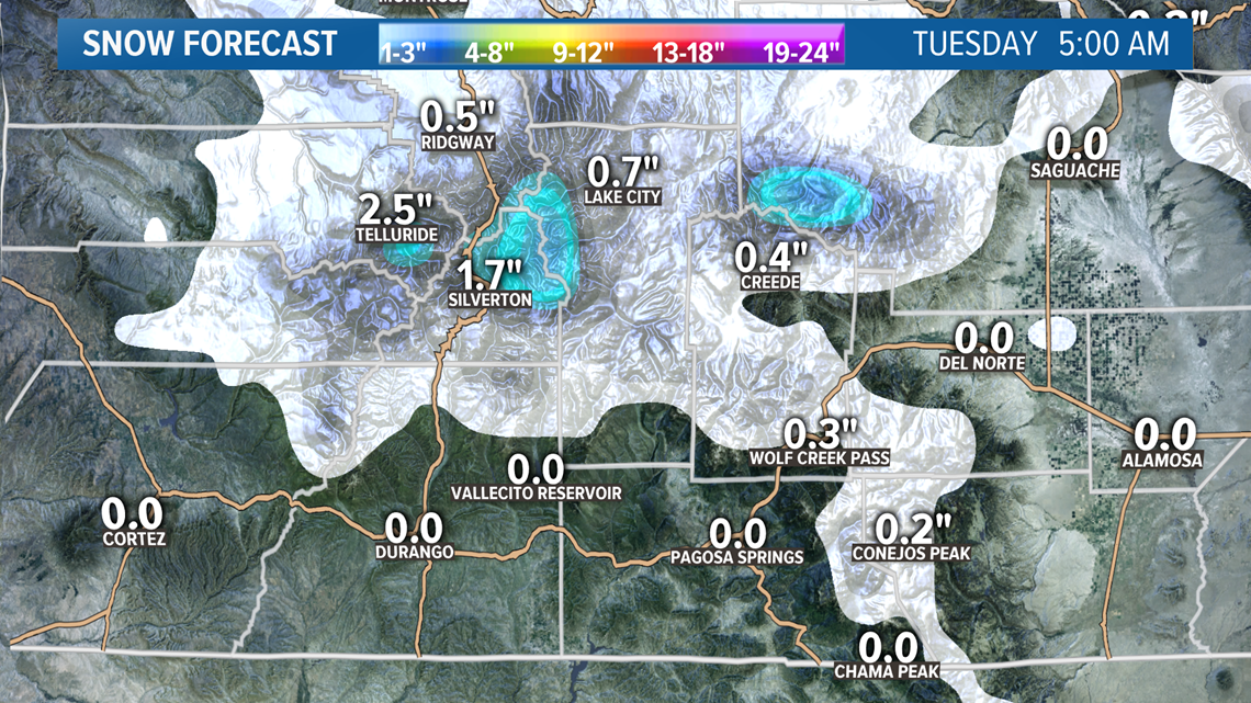
There may be some scattered showers in the Pikes Peak region and the Palmer Divide during the day Monday but mostly light rain. In the evening hours there could be some more traditional stratiform snow in the Pikes Peak area, but accumulation should be pretty light. Probably less than an inch by Tuesday morning at sunrise.
Chance of snow in Denver: 0%
April 21-22
This storm system is moving to the south of Colorado and will bring some better organized snow to southern Colorado.
Snow on the Front Range is not likely except for maybe some light accumulation in the Pikes Peak region again.
Chance of snow in Denver: 0%
April 23-25
The air with this storm system will be coming from the north, so a bit better chance for some snow on the Front Range, but I wouldn't expect anything more than a dusting in the Denver suburbs.
The best chance will be Friday. There is some indication that there could be a half inch or so in some of the higher Denver suburbs. There is 1-5" showing in parts of the foothills though.
Chance of snow in Denver: 5%
April 26-27
Still a weak signal coming from this storm tracking in from the Pacific Northwest. Very little impact to Colorado.
Chance of snow in Denver: 0%
May 3-5
There is something still showing here in the GFS but it's gone back an forth quite a bit.
---------
Saturday update (April 18)
April 19
Snow continues in the Colorado high country tonight and into the day tomorrow. Another 1-4" expected by Sunday night.
Then the showers move down to the Front Range by about 3am. Could be a mix, but with the temperatures at that hour, it will most likely contain some snow. That wave of snow showers will last until about 9am Sunday.

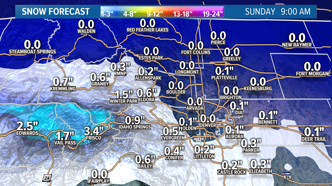
Models are showing some light accumulation in the Denver metro but nothing more than a half inch. The Euro even shows a tenth of an inch out at DIA.
Some of the mountain peaks in the Vail/Summit zone could get close to 4 more inches.

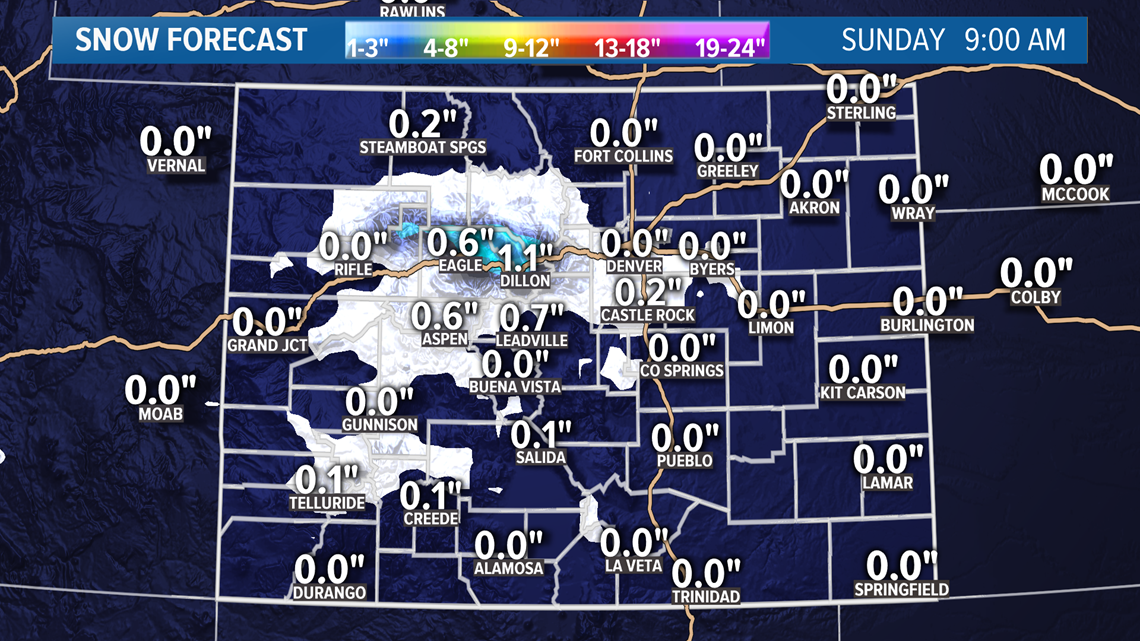
These snow showers will continue in parts of the mountains until after dark Sunday, just before the next system moves in.
Chance of snow in Denver: 15%
April 20
Separating the next two systems now. This one on Monday will bring 1-3" of snow to parts of the high country, but probably won't bring much precipitation to the lower elevations.
Chance of snow in Denver: 0%
April 21-22
Another southern tracking storm system will bring more snow to the mountains on Tuesday and Wednesday.
It looks like this storm will have a better chance to bring some showers to the Denver metro area on Tuesday evening, but it will likely just be rain.
Chance of snow in Denver: 0%
April 23-24
This storm system still looking organized and gaining a little consistency in the models. That consistency is showing temperatures that will be likely to warm for snow accumulation in the Denver area though.
There is some snow being shown in the area though.
Chance of snow in Denver: 5%
April 25-26
Still a weak signal coming from this solution. Very little impact to Colorado.
Chance of snow in Denver: 0%
May 3-4
Not much of a cold signal coming from this one yet.
---------
Friday update (April 17)
April 18-19
A weak upper level disturbance will move through the state Saturday and Sunday. It will deliver about 1-3" of mountain by Sunday night.
Rain and snow showers will reach the Front Range as well, and that includes the Denver metro area. Look for those to reach the area just after noon on Saturday. These storms will likely be mixed with rain, snow, and graupel. Thunder and lightning possible as well.
Snow accumulation of about a half inch will be possible on the Palmer Divide and in parts of the foothills.
Then on Sunday morning it looks like these showers will persist, so that would be a higher chance for snow accumulation with the colder morning temps.
Models are showing about a tenth to a quarter of an inch in the Denver area. There is a slight chance that DIA could get enough to measure, but it would have to get lined up with one of these small and fast moving snow showers. I would guess that is not going to happen, but I'll leave in a low percentage for a light dusting somewhere in Denver.
Chance of snow in Denver: 20%
April 20-22
Then another system moves right in afterwards. This one may have warmer temps so snow accumulation in the Denver area is less likely. There will be a couple shots at rain though. The best chance being Tuesday evening.
Snow will hit the high country again. Could be more in local spots, but overall not much more than 1-4".
Chance of snow in Denver: 0%
April 23-24
This system looks like Denver's next best chance to get snow, although it will likely just have to be a dusting, as temps are trending relatively warm.
At the moment the models like Friday afternoon and evening for a series of mixed rain and snow showers in the Denver metro.
Could be a 1-6" for the mountains.
Chance of snow in Denver: 5%
April 25-26
This system has managed to stay alive in the models but it's looking very weak.
Chance of snow in Denver: 0%
May 2-3
The GFS beefed up this storm system in today's runs, but it has not gone as far as showing some snow in the Denver metro area.
---------
Thursday update (April 16)
April 17
This storm system will be done with the northern part of the state Friday, but some snow showers will continues in the southern mountains in the morning, and then another brief resurgence down there in the evening.
Most places in southern Colorado will get less than an inch of snow tomorrow, except for parts of the southern Sangres where they could get 1-3".
April 18-19
The storm pattern stays active in Colorado although the temperatures probably won't be quite low enough for much snow accumulation on the Front Range with the next couple of systems.
This one moves in on Saturday and brings mostly 1-3" of snow to the mountains, with more to the south than the north.
These showers will reach the Front Range by Saturday afternoon. The precipitation will likely be a mix of rain, graupel, and even some snow. These showers will be brief and scattered widely.
Then on Sunday morning there might be a better chance for the Denver metro area to pick up a snow shower. The Euro even shows a little snow accumulation in parts of the Denver suburbs, the foothills, and the Palmer Divide.
That accumulation could be up to a half inch. Models are not showing snow at DIA.
Chance of snow in Denver: 5%
April 20-22
This little series of systems in showing about 1-6" of snow in the Colorado high country.
There will very likely be mixed rain and snow showers in the Denver area with these, but no snow accumulation is being indicated in the modeling.
Chance of snow in Denver: 0%
April 23-24
This signal has been gaining some consistency in the modeling now. Looks fairly organized with snow very close to the Denver area, and some decent snow numbers in parts of the mountains.
Doesn't look like a snow signal for Denver yet, but it's trending that way.
Chance of snow in Denver: 0%
April 25-27
While the system in front of this one is trending up for snow, this one is trending down again. Currently showing just light mountain snow.
Chance of snow in Denver: 0%
May 2
This weak signal has been pushed back another day in today's GFS runs.
---------
Wednesday update (April 15)
April 16-17
Some of those early, faster moving storms have arrived on the Front Range. Mixed rain and snow showers will continue until later tonight when the more stratiform snow moves in.
Should be about 1-4 inches of snow on the ground in the Denver metro area by the time the sun comes up tomorrow. More to the northwest and less to the south.
With snow overnight, there could even be some snow on the roads early in the morning with some winter driving conditions until the solar radiation can penetrate the clouds.
Snow all day Thursday will about 3-6 inches of accumulation in the Denver metro area by midnight.

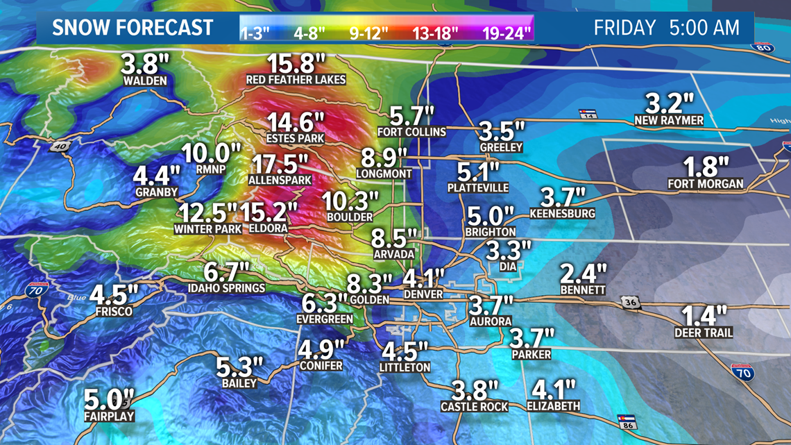
There is a winter storm warning in parts of the mountains with 10-20 inches on the way by Thursday night.

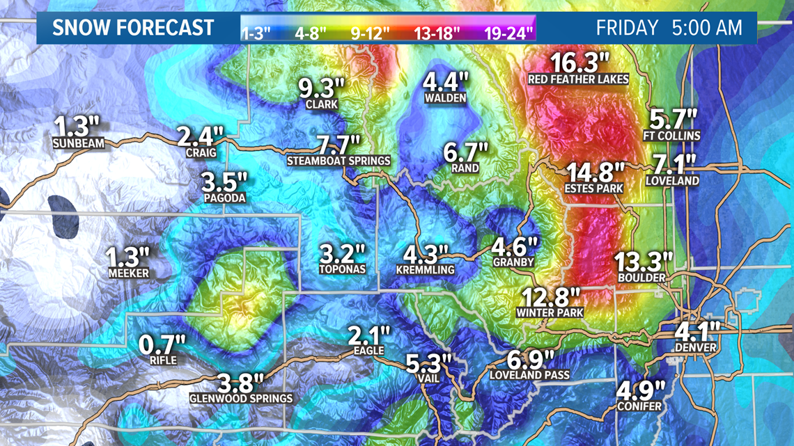
There will likely be no additional snow accumulation on the Front Range after about 4am Friday morning.

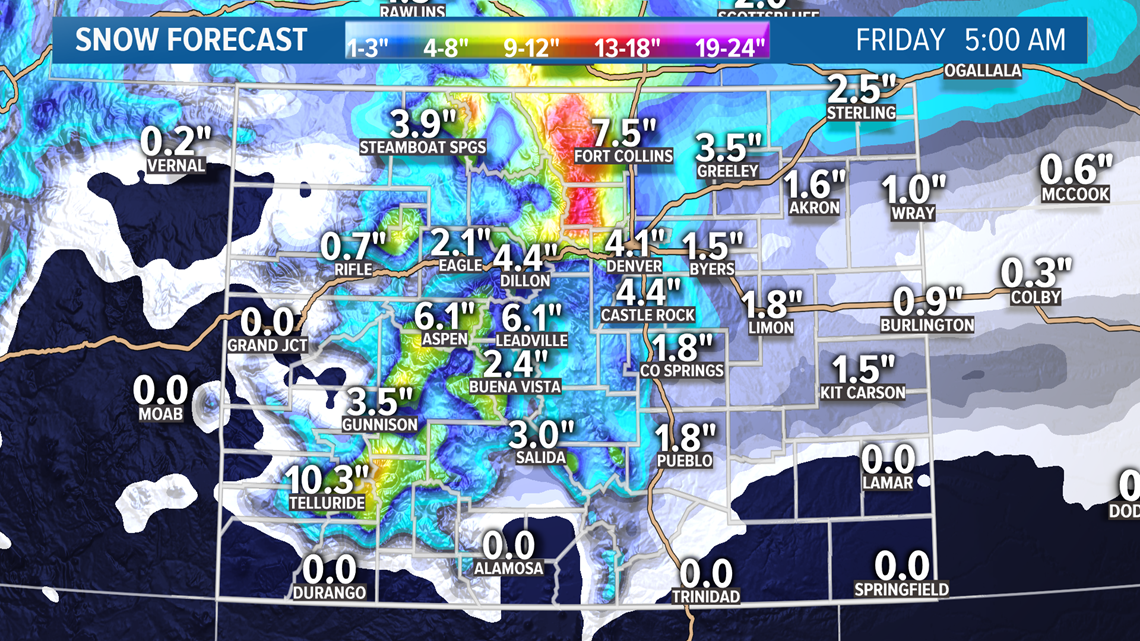
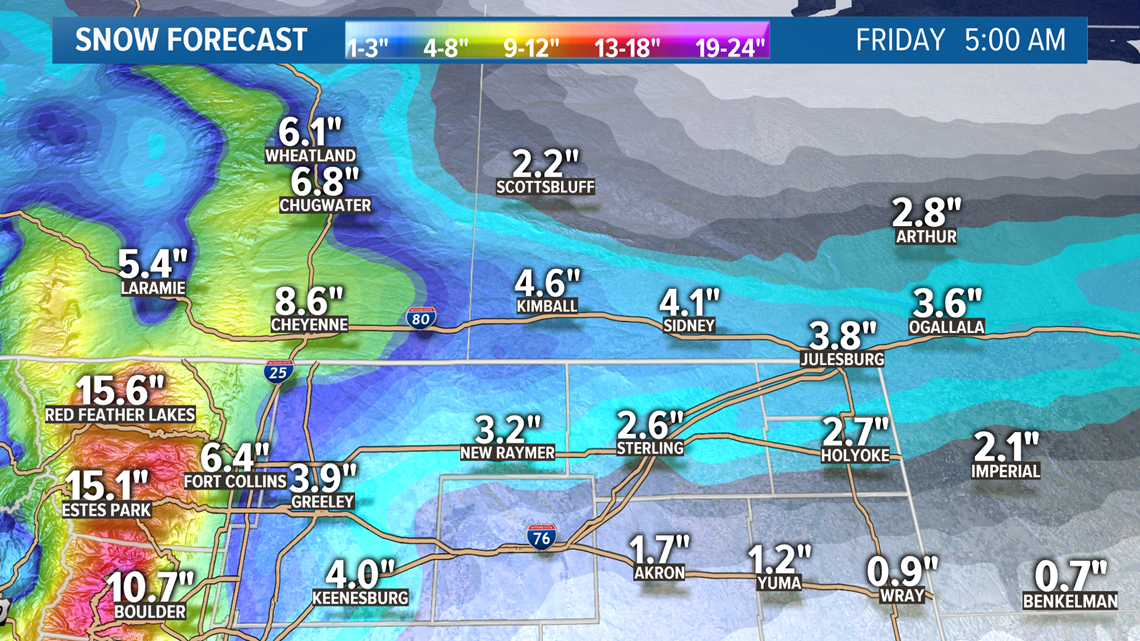
There is also a Winter Storm Warning for parts of southeastern Wyoming and the Nebraska Panhandle for the possibility of 5-10" of snow. The models have been trending down in Nebraska a little. The numbers you see on these maps only show the total with the highest probability. There is usually a least 2 or 3 inches in either direction that is very close to the same probability, so 5 plus is definitely possible.

April 18-19
There is another storm system moving into Colorado on Saturday. The models have gradually been trending rain and mixed snow showers closer to the Denver metro area.
It looks like there will be a chance for a few mixed showers on the Front Range starting Saturday evening and going to Sunday morning. Up to an half inch of snow accumulation will be possible in a few spots. Foothills and Palmer Divide locations probably will have the best chance.
Chance of snow in Denver: 2%
April 21-22
This system is still showing up in the models, but mostly just rain on the Front Range.
Chance of snow in Denver: 0%
April 23-24
This signal is now in range of the Euro, and shows a similar solution to the GFS with some mountain snow showers.
Chance of snow in Denver: 0%
April 25-27
This is the signal that has been showing up fairly strong from time to time in the GFS runs, and you can see that the Euro is now lining something up for this window as well.
This could end up being the next system to monitor for possible snow accumulation in the Denver Metro area. Still too early with too little consistency to say anything other than that.
Chance of snow in Denver: 0%
May 1
Slight storm signal showing in tonights GFS.
---------
Tuesday update (April 14)
April 15-17
The precipitation should stay contained to the mountains on Wednesday until the evening hours. The Front Range will likely get some rain and maybe even a thunderstorm at first and then snow could start mixing in a few hours after dark.
The main accumulating snow probably won't start until midnight but those initial passing storm could bring a little snow.
There should be about an inch of snow on the ground in the Denver area by the time the sun comes up on Thursday. By the end of the day, just before midnight, there should be about 3-6 inches of snow across the metro with more to the west than the east.

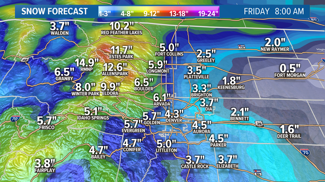
The models are still showing snow into Friday morning, but only an inch or two more across the Denver area. Areas to the south like Colorado Springs will likely get more action on Friday morning with maybe 2 inches or a little more. The storm will clear from the north to the south.

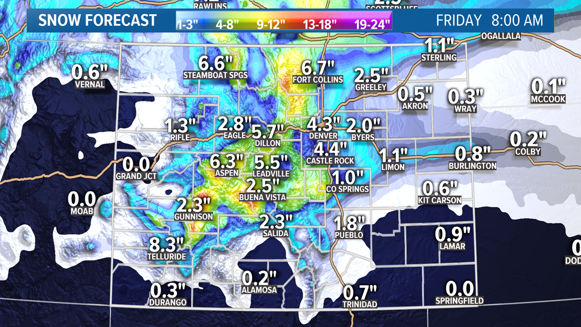
A quick snow shower or a flurry will be possible on the Front Range all the way past sunset on Friday night, but not much in the way of accumulation after the morning.
There are no warnings or advisories out in our area just yet put there is a Winter Storm Watch that includes some of the northern Colorado counties, the Front Range foothills, and some of the I-70 mountain corridor.

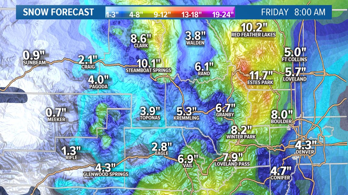
A Winter Storm Warning is in place for the northern mountains where 12-20" of snow will be possible in those high country locations like Rabbit Ears, Cameron, and Gore passes.
Chance of snow in Denver: 100%
April 18-19
Weak disturbance moves across the state bringing some like snow accumulation to southern Colorado. Looks like about 1-2 inches possible. No impact to the Front Range.
Chance of snow in Denver: 0%
April 21-23
This system looks pretty organized but the temperatures won't likely be cold enough in the Denver area for snow accumulation. The Euro has been showing quite a bit of snow on the Palmer Divide a parts of the foothills though so lets watch this one develop.
It is showing the chance for some decent moisture in the Denver area in the form of rain and mixed showers.
Chance of snow in Denver: 0%
April 25-26
This signal survived another round of modeling by the GFS although it shows less of an impact to the Front Range this time around. Decent mountain snow though.
April 30
There was no storm signal again today at the end of the GFS run.
---------
Monday Update (April 13)
April 14
That long storm event is just wrapping up on the Front Range as I write tonight's entry. Doesn't look like there will be too much snow accumulation after midnight except for a little on the Palmer Divide and to the south near Colorado Springs. Probably less than an inch though.
There will be a little resurgence of snow showers in the northern mountains on Tuesday though. I could see a few spots getting a half inch to one inch.
Any clearing of the skies in the early morning will really punctuate that morning low temperature, so we are probably looking at another record at DIA where the record is 15 for tomorrow.
April 15-17
Our next storm moves into the state on Wednesday afternoon with some snow showers in the northern mountains. This storm should be much better throughout the mountains than the previous storm was. We're looking at totals in the 10-24 inch range.
Then the storm moves onto the Front Range that night. Probably see some snow in the Denver area, and maybe even some accumulation before midnight.
It will be snowing in the Denver metro area when we wake up on Thursday morning and it will probably keep snowing through the whole day. It could be a little lighter during parts of the day, but not a complete break.
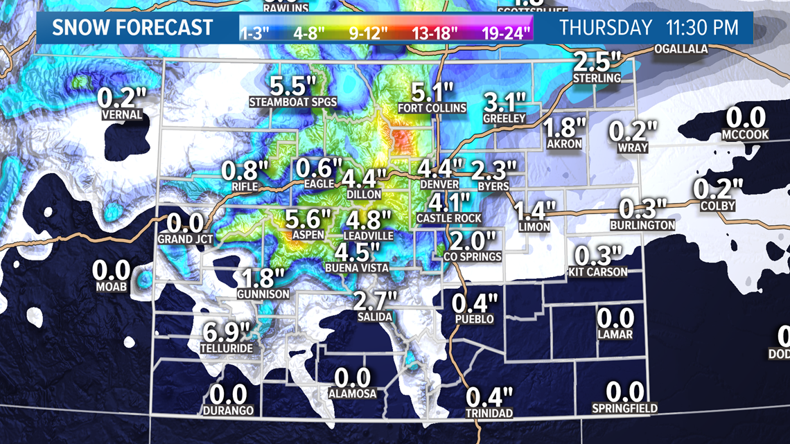
This looks to be another extended snow event but with most of it coming on Thursday. By midnight, there should be roughly 3-6" new inches of snow on the ground, with maybe a few areas to the westside with more than 8".

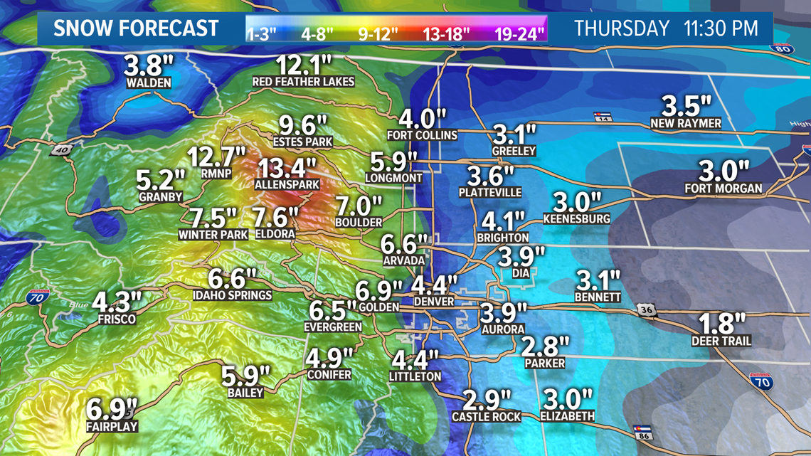
But it doesn't stop snowing Thursday night. If fact, it may snow for most of the day on Friday too. Models area showing an additional 2-4" across the metro just on Friday.

Chance of snow in Denver: 100%
April 18-19
This is a low on the southern branch of the jet stream an will impact Colorado on Saturday and Sunday, but probably not bring any precipitation to the Front Range.
There is a better chance for Colorado Springs to pick up a little snow, but now much.
Chance of snow in Denver: 0%
April 21-23
This storm has been showing mixed rain and snow showers in the Denver area, mostly on that Wednesday. It is showing snow accumulation in the foothills and Palmer Divide, but not in the Denver area.
Chance of snow in Denver: 0%
April 25-26
GFS moved the snow signal from the end of the month into this timeframe. It does show impacts to the Front Range with rain and snow.
April 29
This storm signal was removed today.
---------
Sunday Update (April 12)
Apr. 13-14
More snow on the Front Range Monday. It's really a continuation of today's snow. Light snow and flurries from midnight to the afternoon hours with a few break in-between. Then the heavier snow from about 4pm to about 11pm.
Looks like just another 1-3" for the Denver area with a few in the 4 inch range. This will be on top of whatever we end up with by midnight tonight.
It will be similar to Sunday's snow but instead of most of the snow coming overnight, it will be in the evening hours.

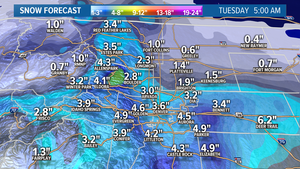
This snow might be a little heavier, or at least seem that way because it will happen when we area awake.
This storm clears the Front Range around 3 or 4am on Tuesday but another one will be moving in right behind it.

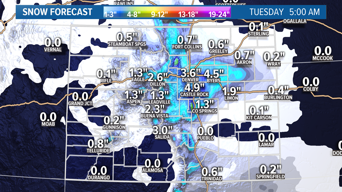
Still on forecast to break a record low temperature tomorrow morning too, even with the overcast skies and snowfall.
Apr. 15-17
Then we turn our attention to the next round of snow that starts Wednesday afternoon in the northern mountains and moves onto the Front Range later that night.
Some parts of the Denver metro could even have snow accumulation before midnight. Most of the snow will probably fall on Thursday though.
Models area currently showing it clearing out by 6am Friday morning, leaving behind another 3-6" of snow in the Denver metro area, and another foot in parts of the foothills.
Chance of snow in Denver: 55%
Apr. 18
This quick disturbance should bring a few inches of snow to the central and southern mountains, but will probably not impact the Front Range.
Chance of snow in Denver: 0%
Apr. 20-22
This looks to be a little more of an organized system but mostly just mountain impacts. Models are showing a few mixed showers on the Front Range.
Chance of snow in Denver: 0%
Apr. 24
A bit of a weak signal showing again here on the GFS.
Apr. 28
This system is still just a slight hint on the GFS radar.
---------
Saturday Update (4/10):
Apr. 12-14
Storm moves into Colorado very late tonight. Before then, it will mostly just be some scattered snow showers in the northern mountains.
Snow starts up along the Front Range after midnight and there should be a coating of white on the ground when we wake up on Easter morning around sunrise.
The first wave of snow should last until about noon on Sunday. For some parts of the Denver metro, some light snow and flurries will continue through the rest of the day, and for other parts of the area, the snow will stop for a while.
By sunset on Sunday, I would expect to see about 1-3" across the Denver metro, with maybe a few spots in the 4 inch range on the west side.

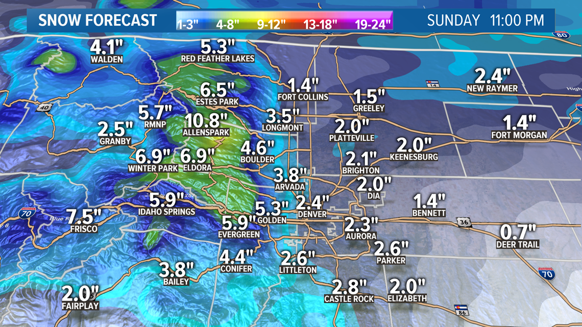
The snow will likely increase intensity just a little bit on Monday morning, but the main wave of snow looks to be from about 4pm to midnight on Monday. This extended storm should break up after sunrise on Tuesday morning.
I would expect another 1-3" to have fallen by 6am Tuesday morning in the Denver metro area, with just a few spots in the 4 inch range.
That leaves a storm total in the 2-8" range, but don't expect to see 8 inches still sitting on the ground in the metro by that time, because even dry snow will compact and melt over time.

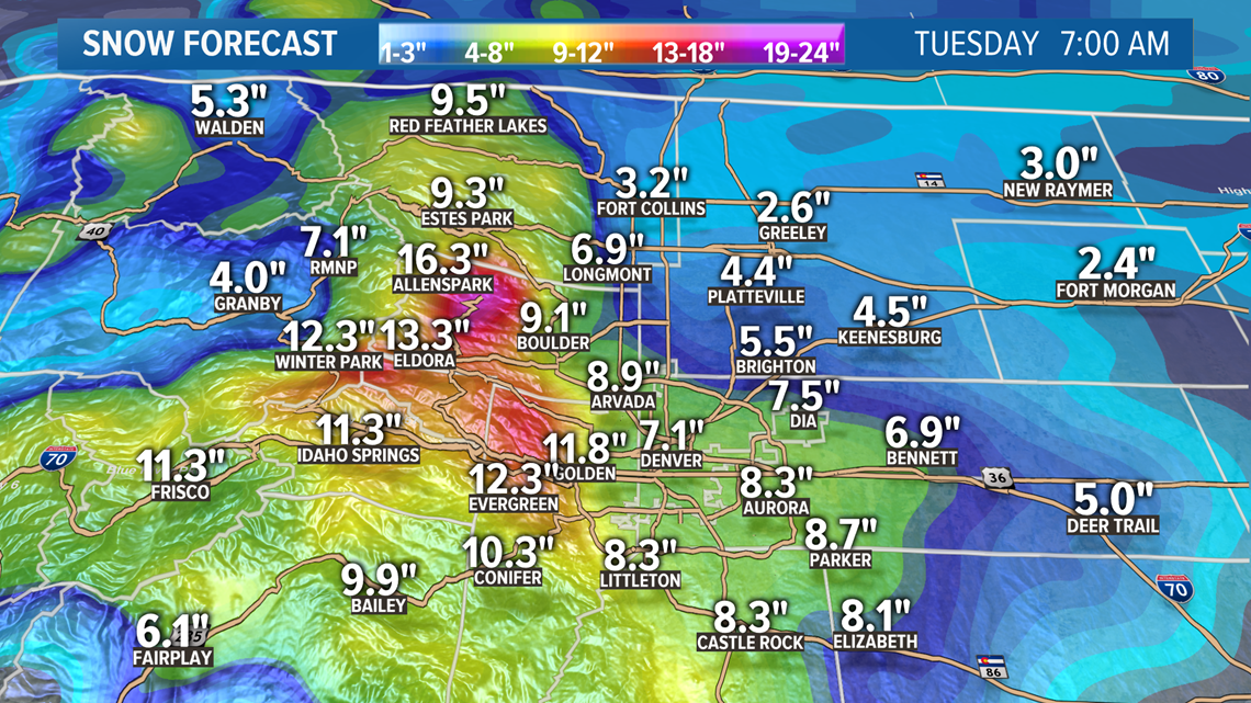
Snow totals should be higher on the west side. So DIA could get 4 inches while Golden gets 8.
It is a different story in the foothills where the snow will be heavier, more continuous, and not melt as much. Many of those areas will easily have 10 inches or more of snow by Tuesday.
This upslope will be mainly focused on the Front Range. There is a Winter Weather Advisory out for some foothills locations, as well as some of the central and northern mountains.

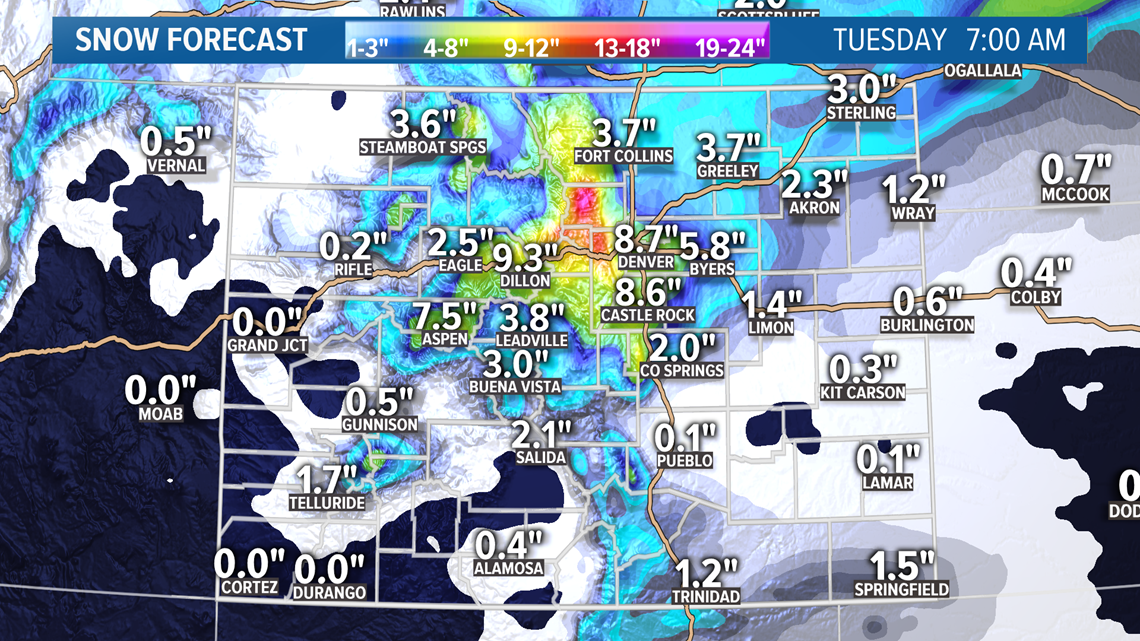
Still no advisories out for the I-25 corridor, and we just might not see any. 2-8" is really not that much snow stretched out over a 48 hour period. Plus with the lower sun angle in April, it is tougher for roads to get icy.
Just scattered showers in the area, mostly foothills and mountains on Tuesday afternoon and evening, but that should be the end of this period of winter weather.
Apr. 15-17
Another winter storm system will be coming shortly after, arriving with snow in the northern mountains by about noon on Wednesday.
Looks like the snow could start accumulating in the Denver area between 9pm and midnight on Wednesday, and this could be another extended snowfall event lasting until Friday morning.
This storm may have similar totals to the first storm mostly in the 3-6" range in the metro and 1 foot range for the foothills. Models have still gone back and forth on the makeup of this system, so not too much consistency.
The one thing that has been consistent is that there has been some sort of snow accumulation in the Denver metro on Wednesday night and into the day on Thursday. So I would definitely expect another dose of snow here.
Chance of snow in Denver: 35%
Apr. 18
A quick southern storm track could bring 1 or 2 inches of snow to the southern mountains.
Chance of snow in Denver: 0%
Apr. 20-22
This storm system has been showing as snow in the mountains, and a few rain showers on the Front Range.
Chance of snow in Denver: 0%
Apr. 24
Another weak signal here but with some mountain snow.
Apr. 27
GFS is hinting at a more organized system here towards the last few days of April, but it's not yet showing any impact to the Front Range.
---------
Friday Update (4/9):
Apr. 11-14
Not too much action on Saturday but by about midnight, the snow should start accumulating up to the north of Ft. Collins.
Snow starting by 3 or 4 am in the Denver metro area. To the northern parts first. Should wake up to a little white stuff on the ground by sunrise on Easter Sunday.
Looks like it may snow straight through to early Tuesday morning no, although overall snow accumulation numbers have come down a bit.
By about 10pm on Sunday night, there should be a good 1-3" of snow on the ground in the Denver metro.

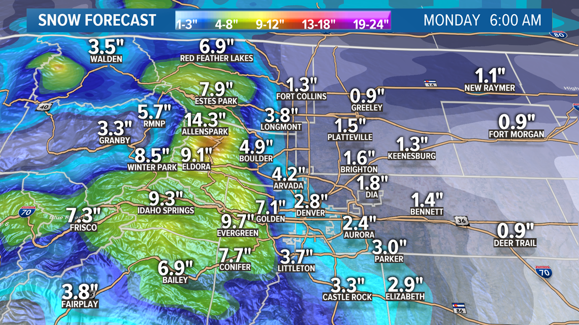
Then by 10pm Monday night there could be 3-6" total.

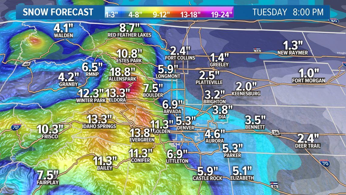
Not much snow for a 48 hour period, but we'll take what we can get as the season winds down. The southern and northern track of the jet will come together at about the same time.

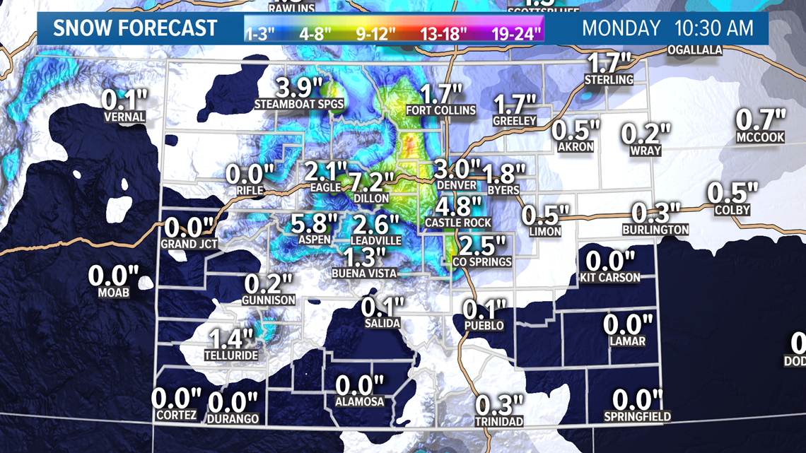

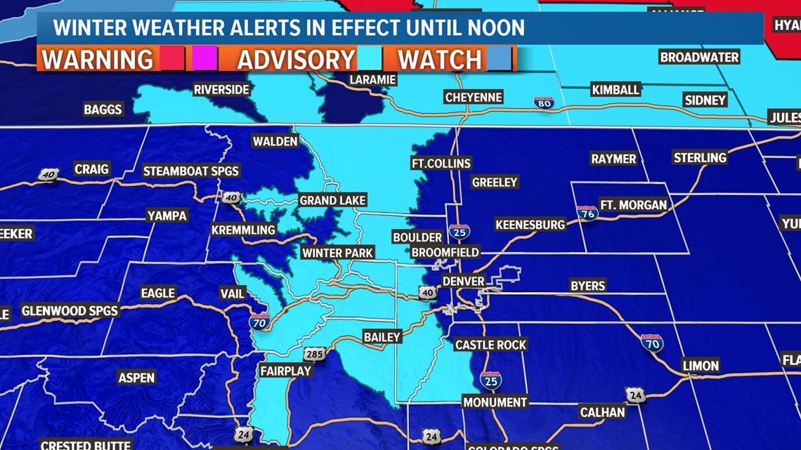
There is a Winter Weather Advisory out for parts of the mountains for 5-12" by 6pm on Sunday night.
Chance of snow in Denver: 100%
Apr. 15-16
This signal is looking much weaker tonight but the models area still showing some snow in the metro on Friday night now. Less than an inch tho.
Chance of snow in Denver: 2%
Apr. 17-19
All these vortexes are spinning off of the same low pressure area so they are seemingly very connected. This signal looks much weaker tonight though. Outside of Easter Sunday, the models are not showing much love for the snow in todays runs. Might be a couple chances at some mixed showers in the is window.
Chance of snow in Denver: 25%
Apr. 19-20
Mixed rain and snow showers possible.
Chance of snow in Denver: 0%
Apr. 21-22
Another weak signal here.
Apr. 24-25
GFS showing a small system with possible Front Range impacts.
---------
Thursday Update (4/9):
Apr. 10
Scattered snow showers Friday in parts of the mountains and scattered rain showers on the Front Range and eastern plains. No snow possible in the Denver area.
Apr. 11-13
A winter storm will arrive on the Front Range late Saturday night.
There will be some rain and mixed snow showers to the north of the Denver area as a cold front moves into the state at about 10pm Saturday. Could even be some snow accumulation north of Ft. Collins before midnight, but most of the snow accumulation will come on Sunday.
The timing is right for this storm to capitalize on overnight temperatures and most everyone on the Front Range will wake up to snow already on the ground for Easter morning. And the snow will keep coming throughout the day.
The models are still showing roughly 3-6 inches of snow accumulation in the Denver metro area by Monday at 4am.

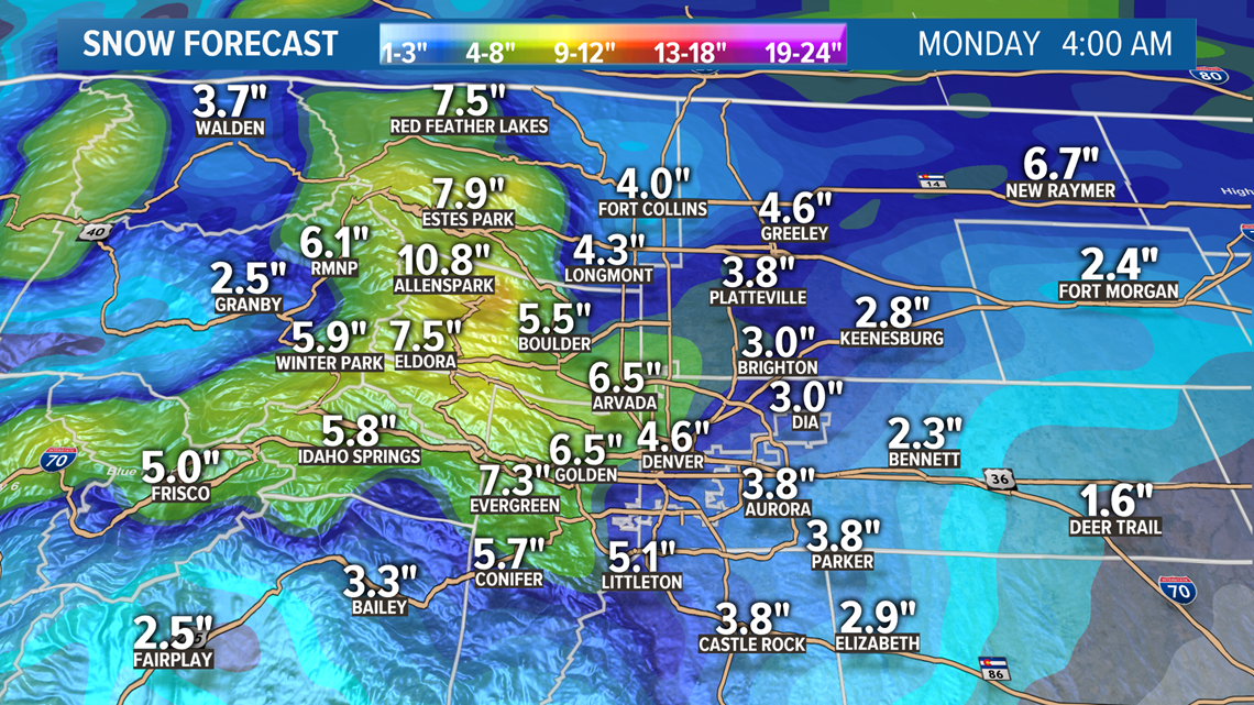
While most of the snow will be on the Front Range, the Park Range, and northeast plains, some other parts of the mountains could get 1-4" of snow.

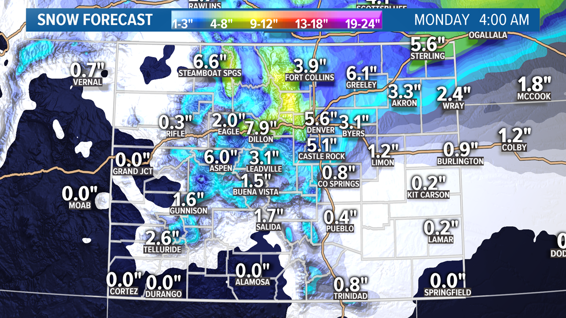
The snow should break up by sunrise Monday morning, but a quick resurgence will be likely on Monday evening. That snow could be heavy enough in spots for additional snow accumulation.
While the temperatures won't be too back during the actual snow part of the storm, there is a chance for morning lows to be in the teens along the Front Range on Monday, Tuesday, and even Wednesday.
Chance of snow in Denver: 100%
Apr. 14-15
I've separated out this disturbance that will bring some light snow to the mountains on Tuesday and the eastern plains on Wednesday morning.
There is a slight chance Denver gets enough of a mixed shower for some snow accumulation.
Chance of snow in Denver: 2%
Apr. 16-17
And yet another system in this cycle, and this one has been gaining momentum to deliver more snow to the Denver metro area. The timing looks to be mostly on Thursday with about 1-3" inches showing in today's modeling.
Chance of snow in Denver: 35%
Apr. 18-19
This signal has been losing steam and shows little impact to Colorado on the latest GFS run.
Chance of snow in Denver: 0%
Apr. 20-21
Another possible system here, but the signal has been weak so far.
Apr. 23-25
This has been a stronger signal although mostly for the mountains and not for the Front Range.
---------
Wednesday Update (4/8):
Apr. 9-10
There will be a weak cold front moving in through the backdoor Thursday from northeastern Colorado. It will be noticeable with more clouds and slightly cooler temperatures.
It will even bring a chance for some rain in spots along the Front Range and eastern plains. Very few spots will actually see enough rain drops to show up on the ground and even less likely to get enough to measure.
There will also be some light snow accumulation in the mountains. Generally about an inch at most.

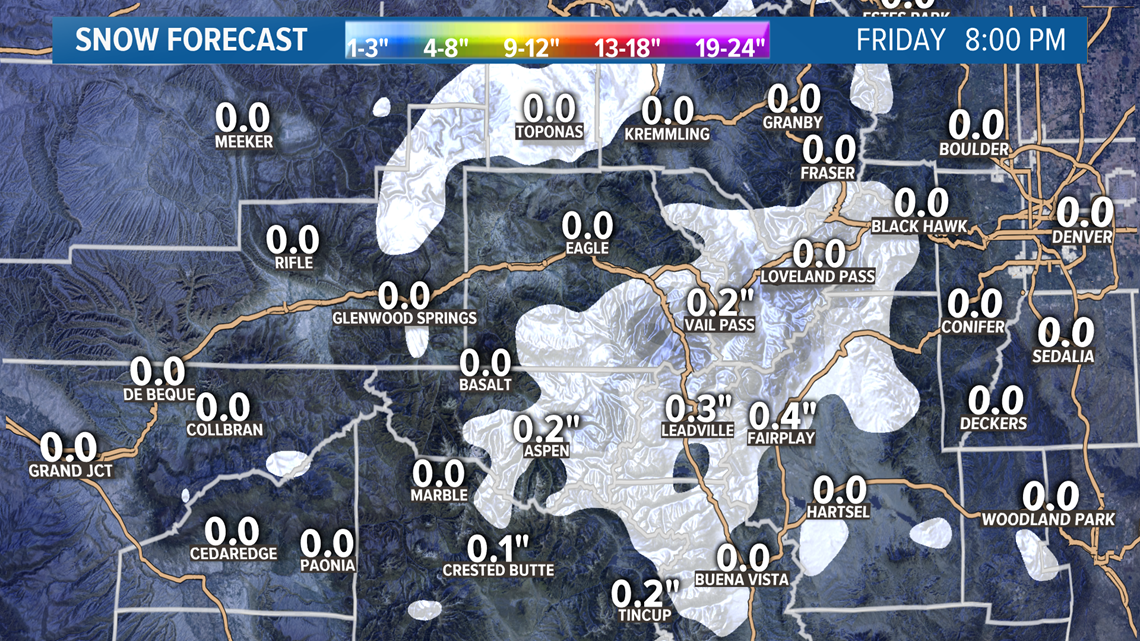
A few mountain snow showers are possible Friday morning as well, but just warm dry winds on the Front Range.
There's a little better chance of catching a rain shower on the Front Range and eastern plains on Friday, but still nothing very widespread.
Chance of snow in Denver: 5%
Chance of snow accumulation in Denver: 2%
Apr. 11-13
Then the storm that will most likely be the main event in this series moves in on Saturday.
Some mountain snow showers on Saturday, and some snow up to the north of Wellington in the Cheyenne area late that night, but most of the snow will come to the Front Range after midnight.
Most of the Front Range should wake up with some white stuff on the ground for Easter morning with snow still actively falling. Models are showing 1" per hour snowfall rates at times, so this should be a decent little spring snow.
Snow should last all day on Sunday and the accumulation projections have come back up to where they were a couple days ago. The Denver metro area is in the 2-4" range with the latest run of the Euro in the 3-6".

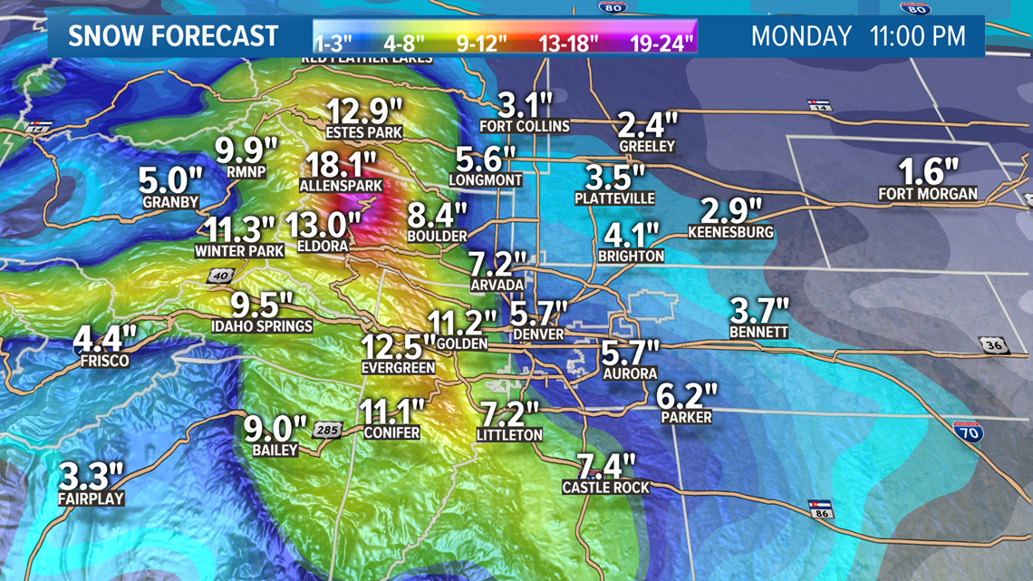
There will be a chance for a foot along the foothills, and closer to 2 feet on the Peak-to-Peak.
Some decent snow in parts of the mountains as well with 2-5" possible in the Summit towns.

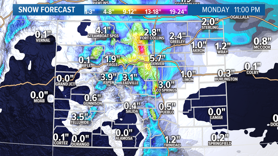
Snow will likely break up late Monday morning on the Front Range but return for a few light showers again Monday evening. Clearing out completely by about midnight.
Chance of snow in Denver: 75%
Apr. 15-17
Then there will likely be more snow in the Denver area with this next storm.
It now looks like it will come very early Thursday morning, so a slight chance from yesterday's runs. The Euro is showing about 1-4" in the Denver metro by Friday morning.
Still quite a ways out but there is a strong signal for second helping of April snow on the way.
Chance of snow in Denver: 15%
Apr. 18-19
This signal has been losing steam and shows little impact to Colorado on the latest GFS run.
Chance of snow in Denver: 0%
Apr. 20-22
All the signals have moved up a day in today's runs. This signal is still showing some Front Range impacts though.
Apr. 23-24
GFS his still showing another late but weak signal here.
---------
Tuesday Update (4/7):
Apr. 9-10
This next storm system will drag a cold front across the area on Thursday. That will create a few mountain snow showers. The numbers in today's modeling have come down a bit, but 1-3" are still possible in parts of the high country.
We'll feel some of that cooler air down on the Front Range but we won't get much of the precipitation. A sprinkle of rain or a quick mixed snow shower is possible, but it will likely yield no rain or snow accumulation in the Denver metro area. Overall precip chances are still going down as this system gets closer.
A flurry or two might be possible Friday morning in the mountains as well.
Chance of snow in Denver: 10%
Chance of snow accumulation in Denver: 5%
Apr. 11-13
The models have become a little less erratic with their solutions on this storm system today, and sadly they have come down on moisture as well.
There could still be a little mixed precipitation in northern Colorado and on Saturday night, but most of the moisture won't get to the Denver metro area until after midnight.
Expect snow to start accumulating in the Denver area around sunrise on Easter Sunday. Relatively warm storm temperatures will prevent too much accumulation, but the models are still indicating that about 2-4" of it will stick in the metro by 3am on Monday morning.
Don't let your guard down with the storm temps mainly between 31-33 degrees, because it looks like some real arctic air will roll in, dropping the temps down to maybe the upper teens on Monday morning and Tuesday morning as well. Those will be damaging to vegetation left uncovered, and also to you backflow preventer if you sprinkler system is already up and running.
Chance of snow in Denver: 55%
Apr. 14-16
Models seem to be locked in on another wave of snow right after that on Wednesday and Thursday. Still a week out but the early indication here is for 1-4 inches of accumulation in the Denver metro.
Chance of snow in Denver: 10%
Apr. 17-18
This storm system survived another day of modeling by the GFS, but it does not show much impact to the Front Range.
Chance of snow in Denver: 0%
Apr. 19-20
This system is still hanging in there too. Some light impacts shown to the Front Range.
Apr. 22-23
GFS does show another system trailing in but pushed it back a day compared to yesterday.
---------
Monday Update (4/6):
Apr. 9-10
A long stretch of warm spring weather is lulling the Colorado Front Range into a false sense of security. Guess what? That happens every year ha. Big changes are being signaled by the computer models.
The first of several wintery storm systems will move into the state on Thursday. It looks like a small batch of low pressure will escape that area swirling of the coast of California and try to penetrate a ridge of high pressure present over Colorado.

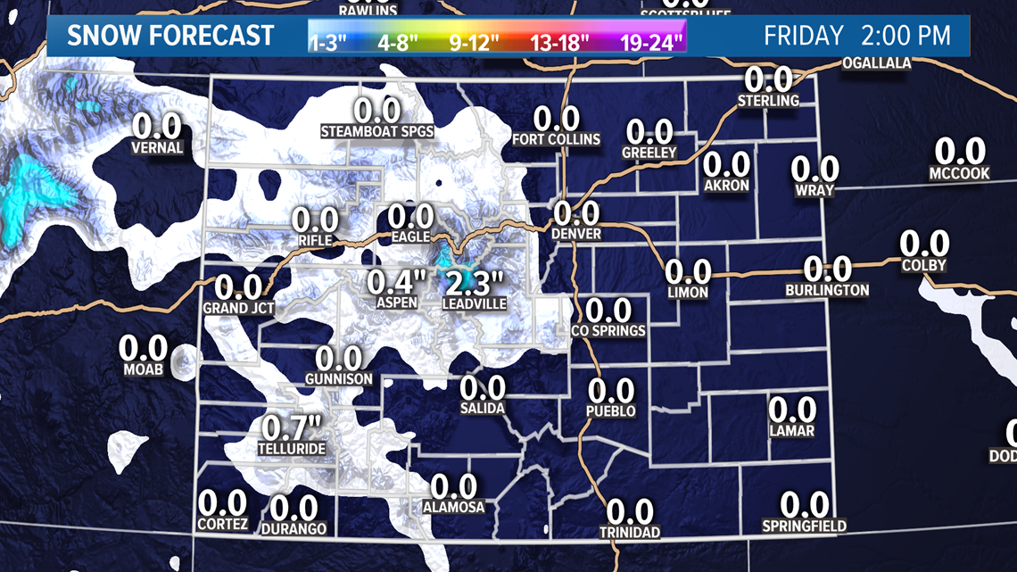
So far it looks like it will be able to deliver 1-4 inches of snow to the high country and maybe even a little snow on the Front Range is possible, but it will likely be too warm there for accumulation.
Best chance to catch a quick mixed rain and snow shower would be Thursday night into Friday morning, but we are not looking at much moisture on the Front Range.
Chance of snow in Denver: 20%
Chance of snow accumulation in Denver: 10%
Apr. 11-13
There continues to be a strong signal in the computer models for snow on the Front Range along with temps in the low 20's, they just can't decide on a day yet.
Today's runs seem to like Sunday as the day instead of Saturday. They have gone back and forth on it a few times. But that signal is definitely there.
The Euro shows snow starting in the Denver area on Saturday night, but the bulk of the snow through the day on Sunday. Both models have show very cold air, especially for April. Many of the runs have shown more than 4 inches of snow accumulation in Denver.
Chance of snow in Denver: 40%
Apr. 14-15
This smaller system is also being shown in the models for another day. Might not have too much impact as far as snow though.
Chance of snow in Denver: 5%
Apr. 16-18
This system is also still in the models. Still showing only light snow impacts to the Front Range.
Chance of snow in Denver: 0%
Apr. 19-20
GFS keeps the colder systems coming with another system here.
Apr. 21-22
And yet another possibility showing up in today's runs of the GFS.
---------
Sunday Update (4/5):
Apr. 9-10
Enjoy the 70 degree weather while it lasts. Changes area coming. First storm in a series will move into Colorado on Thursday with a little snow likely on Friday.

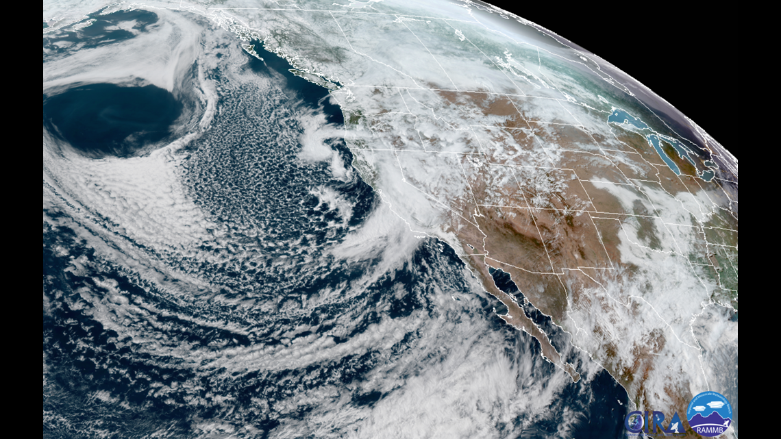
At this point it doesn't look like it will be cold enough for accumulation in the Denver area but a few spots will get a little. Probably less than an inch. Little bit better chance in the Colorado Springs area.
Chance of snow in Denver: 25%
Apr. 11-12
Then it looks like the cold air will arrive after that little surge and bring some more significant snow to the Front Range.
Most of it should be on Saturday but maybe into Sunday morning as well. Early estimates area for 1-4" in the metro, but more where in a little higher elevated locations. That means the Palmer Divide and the Foothills will have a shot at more snow.
Chance of snow in Denver: 30%
Apr. 14-15
Another system may deliver some more snow to the Denver area. Looks like a couple inches possible next Wednesday.
Chance of snow in Denver: 5%
Apr. 16-18
There will be a chance for yet another system effecting the Denver metro here with wintery weather.
Apr. 19-20
This system has survived another day in the GFS modeling but still not showing impacts to the Front Range.
---------
Saturday Update (4/4):
Apr. 5
Quick upper air disturbance moves through the state tomorrow. A few rain and snow showers possible in the high country. Snow will likely be less than an inch.
Just dry downsloping winds on the Front Range.
Chance of snow in Denver: 0%
Apr. 9-10
This is the next potential snow for the Front Range. The trend in the modeling has been for the high pressure that will bring several days of 70 degree weather to eastern Colorado, to break down a little soon now. That will allow a low out near southern California to progress a little sooner.
Then high pressure is now being shown rebuilding in the Pacific Northwest, keeping that lows track closer to Texas. That means the most likely time for snow showers on the Front Range would be Thursday morning instead of Saturday.
The temps will be pretty high. Probably in the 34-36 degree range, but snow accumulation will still be possible in the higher parts of the Denver metro.
Chance of snow in Denver: 20%
Apr. 12-14
That would change the timing of the northern surge as well. This will be a little closer to Colorado, and a little colder, so snow will be likely on Sunday into Monday. Still 8 days away, so much to unfold here.
Chance of snow in Denver: 20%
Apr. 16-17
This system is not in range of the Euro yet, but the GFS has been indicating another system here for a few days now. Not showing Front Range impacts though.
Apr. 19-20
GFS still showing a weak signal here but just a day later. No Front Range impacts indicated.
---------
Friday Update (4/3):
Apr. 4
A few light mountain snow showers will be possible Saturday. If there is accumulation from them, it will likely be less than an inch.
A spotty snow flurry will be possible overnight on the Front Range but no accumulation.
Showers in the Denver metro area tomorrow will be quick an brief. Might not even be enough rain making it to the ground to show up on the pavement.
Apr. 5
Another quick disturbance moves through on Sunday. Even lighter mountain snow showers are expected.
Chance of snow in Denver: 0%
Apr. 9-11
This will be the next system to watch on the Front Range. Models show some mountain snow on Friday, and then some snow on the Front Range including the Denver metro on Saturday.
Early estimates are for 1-4 across the Denver area.
Chance of snow in Denver: 20%
Apr. 12-13
Then the northern branch of the jet stream may reach out just after and bring what will appear to be a continuous period of storms.
Chance of snow in Denver: 10%
Apr. 15-17
GFS has been holding on to this solution quite consistently. Showing some impacts to the Front Range but mostly the higher elevations.
Apr. 18
This is a new solution showing on the end of the GFS run tonight. Some mountain snow possible.
---------
Thursday Update (4/2):
Apr. 3-4
Most of the snow from this system will wrap up by about 3am, but light snow and flurries will remain possible in the Denver area throughout the day on Friday. Models even show a few snow showers on Friday afternoon.
Snow accumulation from midnight through the day Friday will likely be less than an inch on the Front Range.

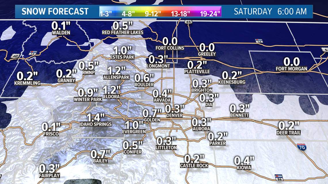
Saturday will feature a few light mountain showers and even a few quick snow showers near the Front Range, mostly foothills and Palmer Divide. Accumulation is not likely though.
Apr. 5
Another quick disturbance moves through on Sunday with just a few light showers. Mostly on the Western Slope.
The Front Range will mostly get the warmer downsloping winds.
Chance of snow in Denver: 0%
Apr. 6-8
A ridge starts to build into Colorado at this time, limiting shower activity. Can't rule out a quick rain shower, but snow will not be possible on the Front Range.
This will be the first long stretch of 70 degree weather in the Denver metro.
Chance of snow in Denver: 0%
Apr. 9-11
It looks like there will be a batch of low pressure off the coast of Southern California waiting for our ridge to break down. Once that happens, models are showing that it will be headed our way.
This will be the next system to watch for potential snow in the Denver area. At the moment, the best chance looks like Saturday the 11th.
Chance of snow in Denver: 15%
Apr. 12-13
As the southern branch of the jet stream comes together again with the northern branch, there may be another system right on the heels of the previous one.
If that happens, we could get back to back days of snow in Denver.
Chance of snow in Denver: 5%
Apr. 14-17
This signal remains in the GFS solution today.
---------
Wednesday Update (4/1):
Apr. 2-4
A storm system is pushing down from the Pacific Northwest tonight. It is expected to stay mostly to the north of Colorado but some wintery impacts are expect tomorrow.
There will be some mixed rain and snow showers in the morning Thursday and there could even be a little snow accumulation before noon in the foothills or in the Boulder area, but most of the accumulation won't come until after noon.
The best snow in the Denver area will happen between 5pm and 10pm. With temperatures being relatively high, the snow won't stick to the major roadways.
Most of the snow totals in the metro will be in the 1-2" range, with very few spots going over 3 inches. The best chance of going over 3 inches in out area is probably Boulder, Golden, and Evergreen.

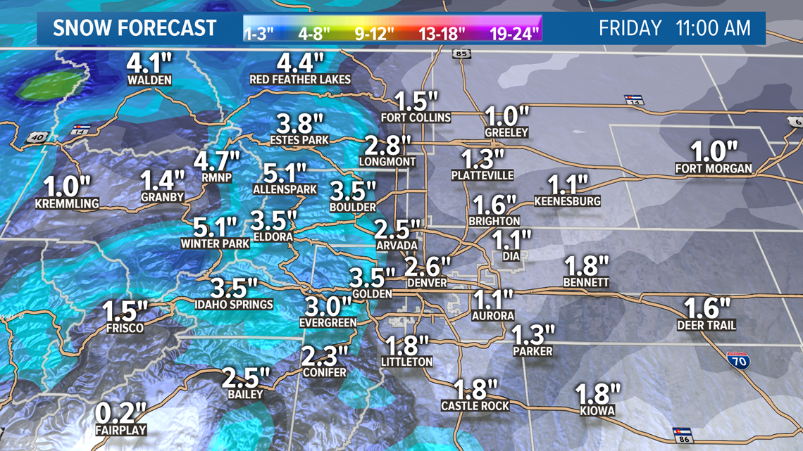

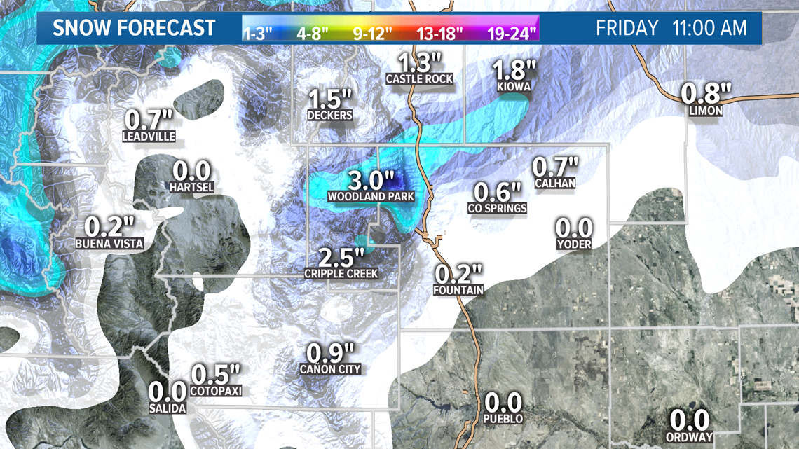
There is a Winte Weather Advisory out for northwest Colorado for 1-4" of snow with a few areas capable of seeing a little more. 4-8" will be possible in select spots above 10,000 feet.


Flurries will remain in parts of the foothills through the day on Friday, and a few mixed showers will be possible on the Front Range on Saturday morning as well. No additional accumulation is expected though.
Apr. 5
This glancing system will likely bring some light snow showers to parts of the mountains. Roughly about an inch possible in spots.
Chance of snow in Denver: 0%
Apr. 6-8
Models show a couple of storm systems getting split by a strong ridge of high pressure. There could be a few light snow showers or mixed showers in the mountains during this time, but it will mean 70 degree temps on the Front Range.
Can't rule out a quick thunderstorm in spots but certainly no snow.
Chance of snow in Denver: 0%
Apr. 9-11
Once that ridge breaks down, it will allow the low pressure split down to the southwest a chance to move our way. Models show, at this point, that it will likely have an impact on the Front Range when it comes through.
For now, this is the next signal that we will have to watch for snow in Denver. Models show some on that Friday (Apr.10) night into Saturday (Apr.11) morning.
Chance of snow in Denver: 5%
Apr. 12-14
The GFS continues to show the northern system sweeping through right after that with some possible Front Range impacts.
Apr. 15-17
Still a slight signal here as well. Could be our first chance at some severe weather in Colorado.
---------
Tuesday Update (3/31):
Apr. 2-4
Not much has changed with this system in today's modeling, except a little with the timing.
The Cheyenne area could see some good snow very early in the morning on Thursday and could get 2-4" by 6 p.m.
The snow showers move into the Denver area just afternoon on Thursday but there probably won't be accumulation until after 3 or 4 p.m. The heaviest snow in the metro will be between 5 p.m. and 10 p.m. but will likely continue lightly around the area until about 11 a.m. Friday.

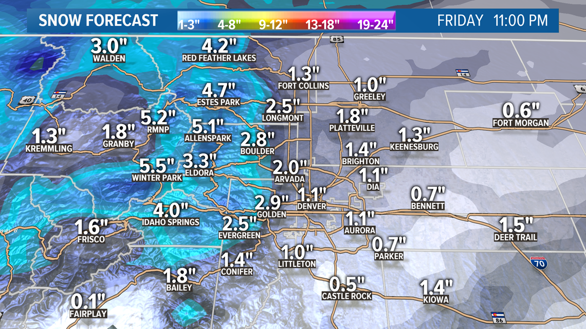
There probably won't be any accumulation after noon on Friday, although a quick mixed shower or flurry will be possible all the way into Saturday morning.
Snow totals in the Denver area will likely be in the 1-2" range with the foothills north of Interstate 70 in the 2-4" range.
The other notable area looks to be the Pikes Peak region with 2-4" possible between Colorado Springs and Woodland Park.

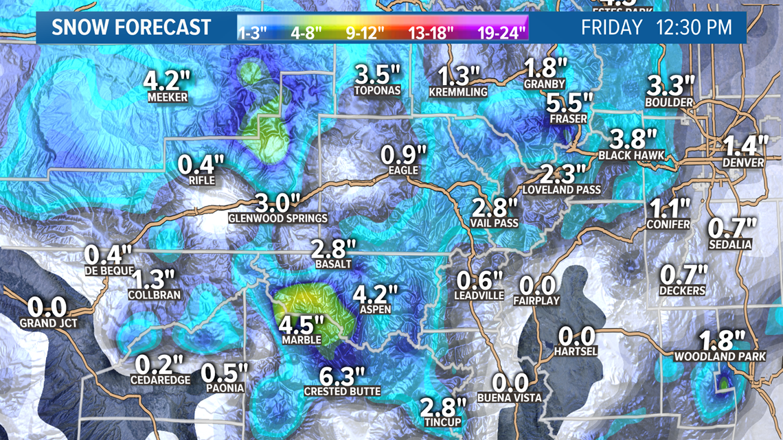
The mountains are looking at 3-6" of accumulation but most of the mountain towns are in the 2-4" range.
The models are showing a band of snow stretching from the Colorado Springs area to the northeast corner of the state. That will probably just mean the difference between getting 2 inches instead of less than one.

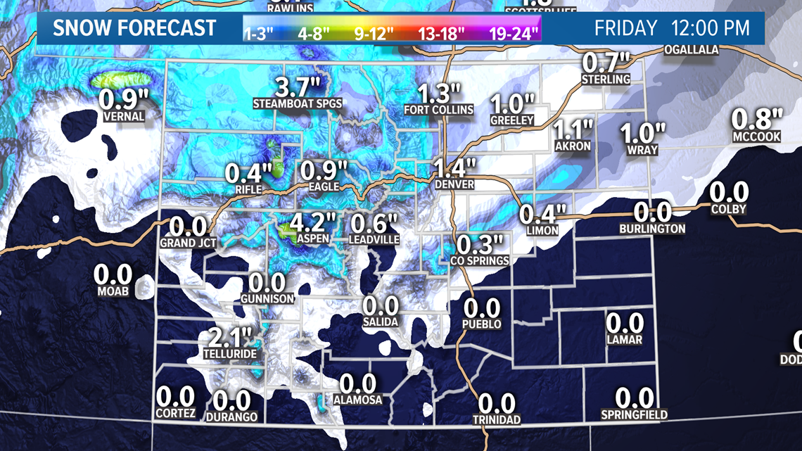
The chances of DIA getting snow accumulation out of this storm are moving up.
Chance of snow in Denver: 45%
Apr. 5
Adding this small chance of western Colorado getting brushed with a couple inches of mountain snow.
Chance of snow in Denver: 0%
Apr. 6-8
The next few systems are still showing in the models today however with different timing and they look a bit more sloppy.
This storm looks to bring mostly mountain impacts now with just mixed showers on the Front Range with little to no accumulation.
Chance of snow in Denver: 0%
Apr. 9-10
This one still shows some light snow possible on the Front Range on that Thursday.
Apr. 11-13
The GFS shifted the snow producing storm into this window today. Nothing consistent.
Apr. 15-16
GFS is showing the chance at a wintery storm in this timeframe.
---------
Monday Update (3/30):
Apr. 1
This storm system will actually blend in with another one behind it but it makes sense to separate it because of its light impacts.
It will bring some scattered mountain snow showers throughout the day Wednesday, amounting to maybe up to an inch of snow in spots.
The showers will likely make it onto the Front Range and eastern plains on Wednesday evening but they will likely just amount to a brief rain shower for a few spots.
Chance of snow in Denver: 0%
Apr. 2-4
This will be a more organized surge of cold air into Colorado that will result in some snow accumulation on the Front Range Thursday into Friday morning.
So far the models show the snow accumulation beginning to the north of the Denver area first and reaching the metro by about 10 or 11 a.m.
Early estimates are for roughly 1-2" across the Denver Metro with 2-4" in parts of the foothills.

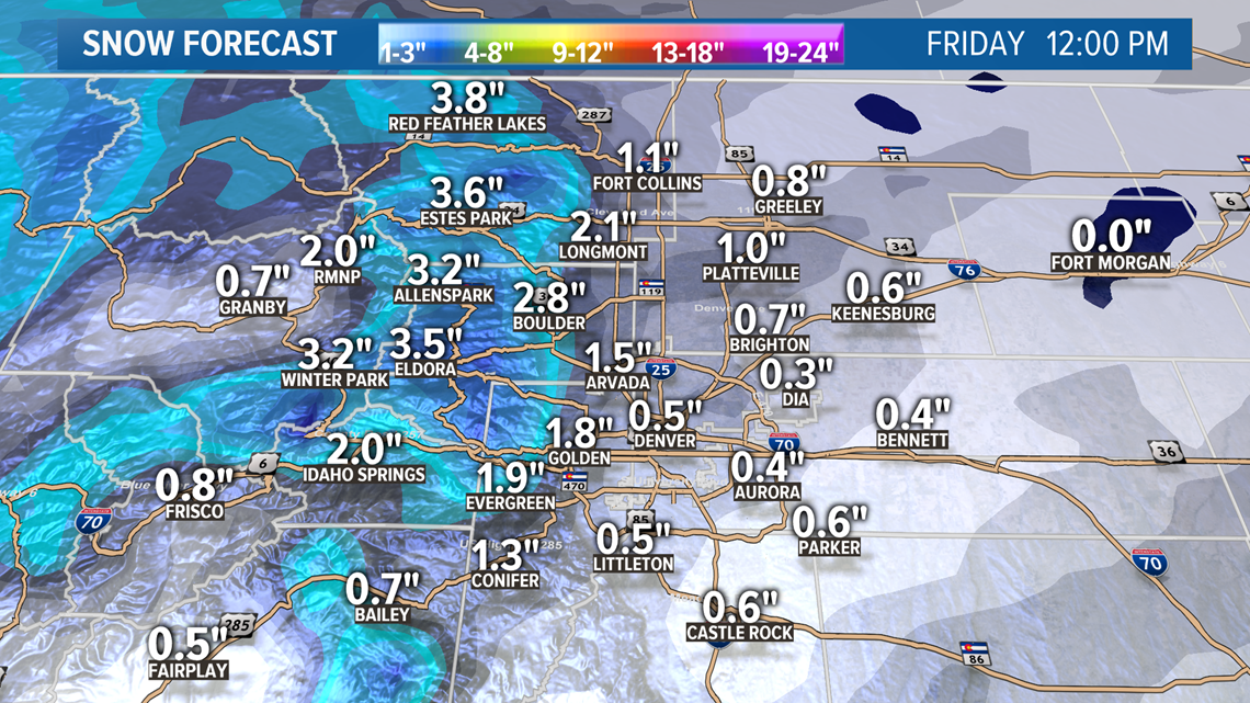
Mountains could get 1-4" of snow above 10,000 feet, and 1-2" in the mountain towns.
Snow could last on the Front Range until about noon on Friday, but some light mountain snow showers will be possible Saturday.

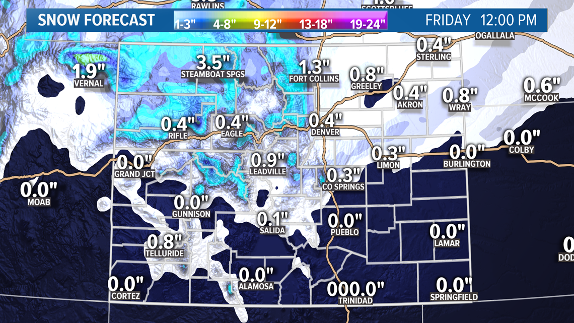
There is a chance that there is no measurable snow at DIA with this, but the models have been consistently showing at least a half-inch there for several days now.
Chance of snow in Denver: 30%
Apr. 6-8
This storm system has been gaining momentum in the last two days as another dose of snow for the Denver metro. So far the models have shown the system more organized and on the southern branch of the jet stream.
So far the models show snow in the Denver area on that Tuesday night into Wednesday morning. This one is still 7 days out, so it's just now coming into a reliable range.
Apr. 10-12
Both models are hinting of another system here with possible impacts to the Colorado Front Range, but it has not been very consistent about it.
Apr. 14-15
The GFS is holding onto this very active stretch of possible wintery storms with one more system in this window.
SUGGESTED VIDEOS | Science is Cool

