BOULDER, Colorado — The temperature of the ocean water in the tropical Pacific Ocean west of South America is already warmer than normal, which is a condition known as El Niño.
A new climate model developed at the National Center for Atmospheric Research (NCAR) is predicting that warming will continue into December, becoming one of the warmest or strongest El Niños in history.
“It’s very much the case that the stronger the El Niño, the greater the impacts," said NCAR research scientist Steve Yeager.
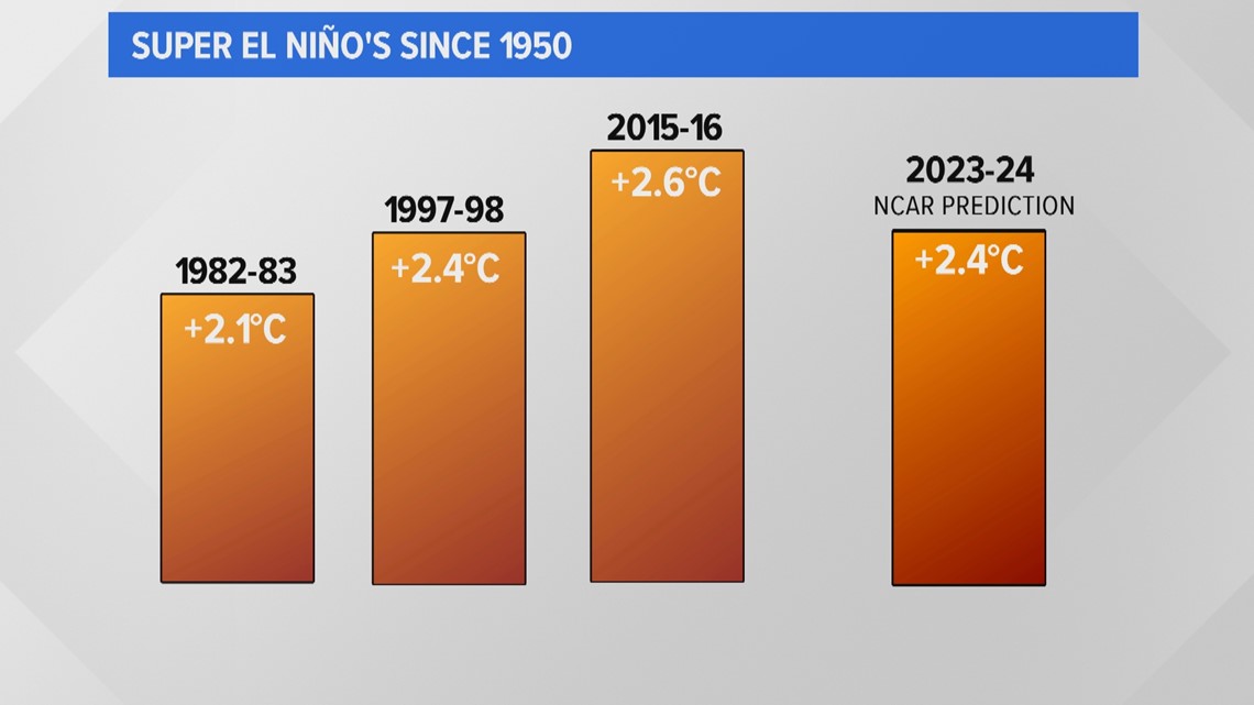
He said when an El Niño warms to a wintertime average of more than 2 degrees Celsius above normal, it's often referred to as a super El Niño. That's not an official term but he said it's just becoming an acceptable description in the media, the public and also among scientists.
And there have only been three occurrences of super El Niños since 1950, when sea surface temperature records began.


The new NCAR prediction system shows that this winter’s El Niño could rival those other super El Niño seasons.
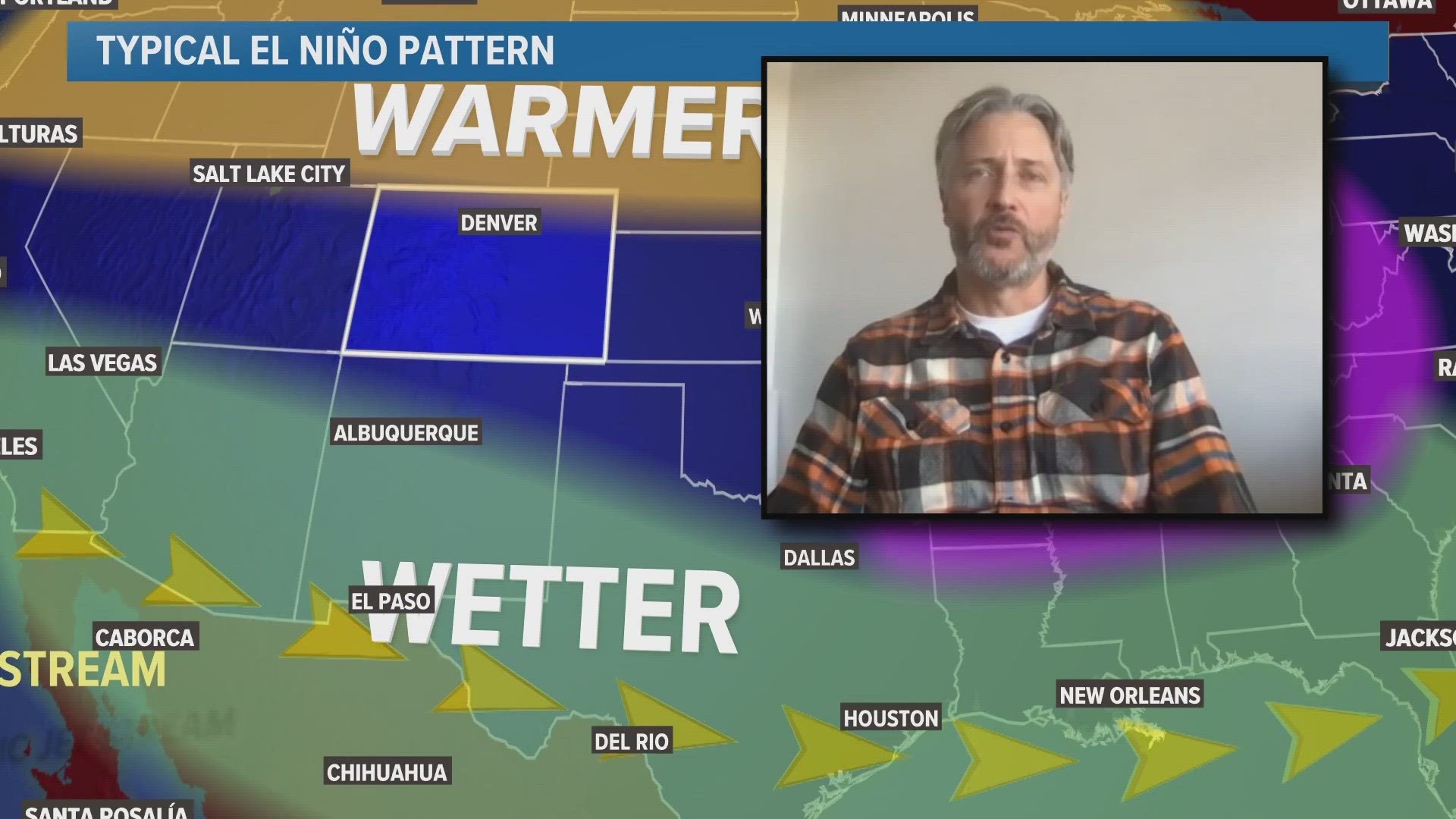
Which is important to know because he said strong El Niño conditions can result in some reliable weather patterns over the winter months. In particular, wetter than normal weather in the southwestern states and warmer than normal weather to the north.
But how does Colorado fit in?
“I personally wouldn’t want to make a prediction about what’s going to happen in Colorado, and I get asked that a lot," said Yeager. "Colorado’s kind of in between the zones where there are really strong impacts, so it could go either way.”


He said there just haven't been enough examples of super El Niños through history to establish a dependable connection to small areas like cities or states, but he said there is a high likelihood of weather patterns to develop similar to the ones in the 1997-98 super El Niño.
That season was marked by flooding in South America, extreme rainfall in Central Africa and one of Indonesia's worst droughts in history. And the Pacific basin saw 11 super typhoons, the most in history.
In Colorado, all three previous super El Niño seasons were colder and snowier than average on the Front Range. Denver got more than 70 inches of snow in Denver each season, which is well above the average of 56 inches. Statewide snowpack was slightly below average in 2016, but slightly above average in 1998. Traditional statewide snowpack was not recorded in 1983.
Yeager said the key to predicting winter weather patterns in the future will likely depend on accurately predicting the strength of each coming El Niño.
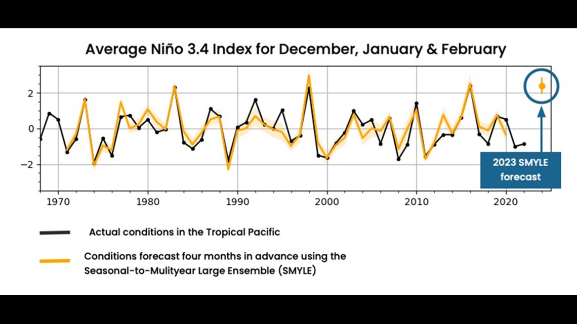
Which is something his new model has already shown in simulations. Yeager just completed a research project in which he had the NCAR model reforecast previous El Niños and La Niñas based on global climate conditions at the time. The graph below shows that the predictions made by the model marked by the orange line, captured the actual observations including the three super El Niños.


“That’s really exciting." said Yeager. It means that our science is kind of coming into fruition of being actionable. Of being useful to society, which is a very gratifying thing.”
And he said the next big thing in El Niño forecasting will be determining something he calls the flavor of conditions, which is basically which part of the ocean is warming the most. He said if only the central part of the El Niño ocean region is warmer than average it will have a much different impact than if just the eastern or western side of the El Niño region is warmer than average.
Climate Impact
Yeager said that climate change is impacting scientists’ ability to predict El Niños because the climate is warming so fast that modeling is having a hard time keeping pace with new normals almost every year.
"The warming climate is also affecting other ocean basins that impact weather patterns," he said. "For example, the Gulf of Mexico and much of the rest of the Atlantic is record warm, so it will be very interesting from a science perspective to see how those offset, diminish or enhance this winter's El Niño."
He also said that more moisture is getting added to the atmosphere as a result of climate warming, which is making extreme single events more frequent. That can dramatically alter averages, so it's kind of like trying to hit a moving target as a forecaster.
SUGGESTED VIDEOS: Colorado Climate

