DENVER — A cold front has pushed into Colorado bringing much colder temperatures and snow showers.
While this storm doesn't look to be nearly as impactful as the Oct. 28-29 snowstorm that brought 7.5 inches of snow to Denver, higher elevation foothills could see a few inches of accumulation on Wednesday night and Thursday morning.
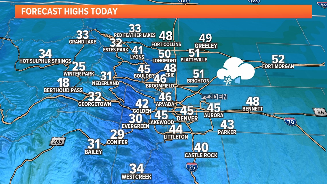
The front will drop high temperatures in Denver from the 70s on Tuesday to the mid-40s for Wednesday.
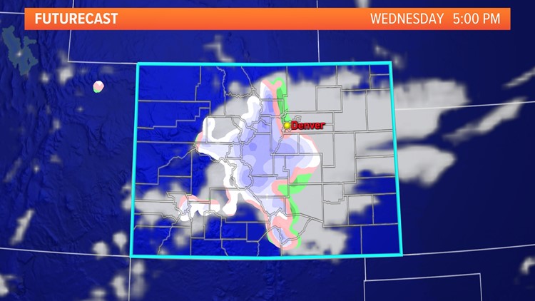
Once the front moves through, rain and snow showers will gradually develop during the day Wednesday around the Denver metro area. Any rain should flip to snow pretty quickly Wednesday night, with the potential for a quick 1 to 5 inches of snow in the foothills and along the Palmer Divide, generally above 6,000 feet in elevation.
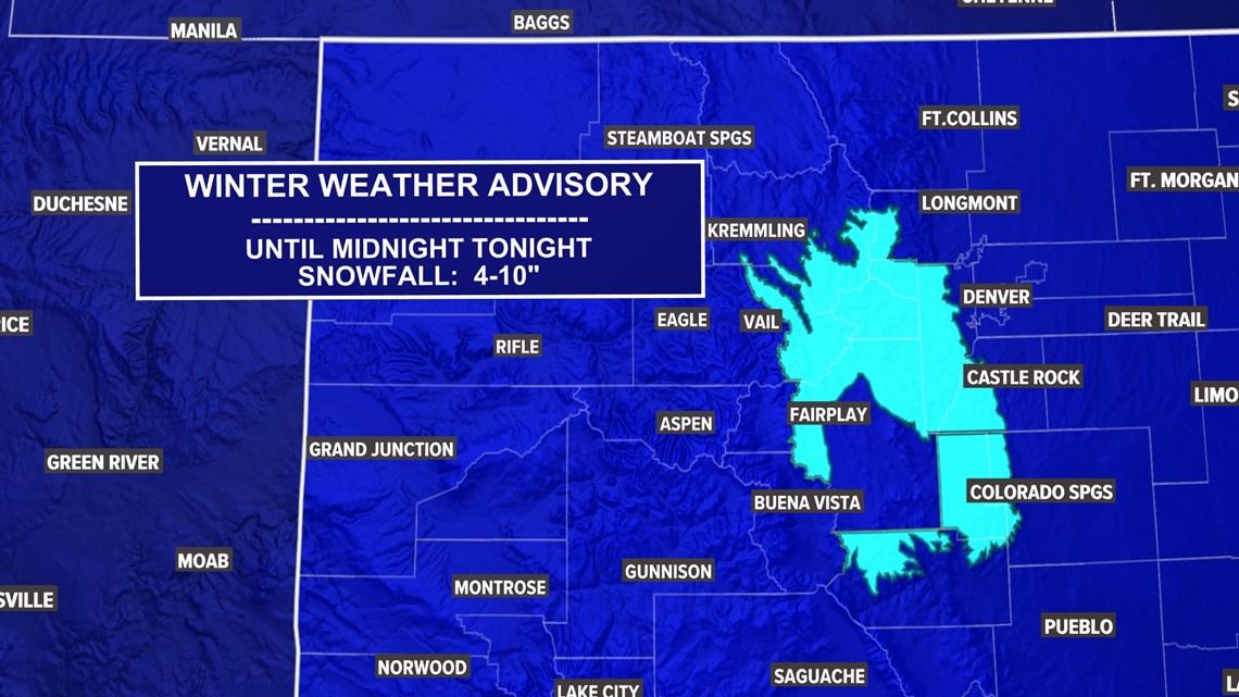
A Winter Weather Advisory has been issued for the southern foothills and adjacent mountains for the heaviest snow with 4 to 10 inches possible.
In Denver, look for a slushy coating to perhaps an inch or so of accumulation, most of which will fall after dark on Wednesday. Because of Tuesday's warm temperatures, the ground should stay warm and impacts to roads should be limited.
Expect road impacts on Interstate 25 on the Palmer Divide, Monument Hill, and Interstate 70 along and west of Lookout Mountain on Wednesday night into Thursday morning.
In Denver, again, a dusting to perhaps an inch or two of accumulation looks most likely. The west and south sides of the metro area will probably see the higher amounts, with little if any accumulation on the north and east sides of town. Again, the Denver area will probably see its snow on Wednesday afternoon and night.
The snow will probably start as rain in Denver and other lower elevation areas, and the rain might start as early as Wednesday morning. The flip to snow will probably take place during the afternoon or early evening.
In the mountains, heavy snow is likely throughout much of the day on Wednesday and into Wednesday night. A few mountain areas could see as much as a foot of accumulation, though most mountain locations will see less than that.
Areas east of the Continental Divide and above 8,000 feet in elevation will be the most favored for higher accumulations and higher snow and ice impacts.
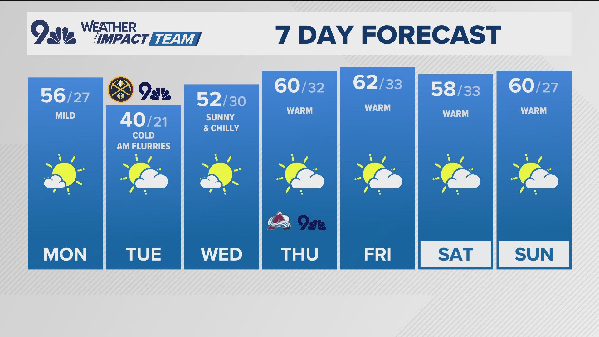
Temperatures will be the other big story with this week's system, with highs crashing from the 70s in Denver on Sunday, Monday, and Tuesday down into the 40s by Wednesday and Thursday. Overnight lows could plunge as low as 20 degrees on Thursday morning.
Highs rebound pretty quickly though, with a high back in the 50s in Denver by Friday and 60s likely next weekend.


MORE WAYS TO GET 9NEWS
Subscribe to our daily 9NEWSLETTER
Download the 9NEWS APP
iTunes: http://on9news.tv/itunes
Google Play: http://on9news.tv/1lWnC5n
ADD THE 9NEWS+ APP TO YOUR STREAMING DEVICE
ROKU: add the channel from the ROKU store or by searching for KUSA.
For both Apple TV and Fire TV, search for "9news" to find the free app to add to your account. Another option for Fire TV is to have the app delivered directly to your Fire TV through Amazon.