DENVER, Colorado — Denver did end up getting a couple of inches of snow last Thursday, but it won't show up in the record books.
That's because Denver's official weather station is out at Denver International Airport (DIA), where they only reported a trace of snow.
Now that snow has fallen, we're looking ahead to the next storm.
SUNDAY UPDATE
Oct. 27-28
It was snowing in Denver at the time of this update, but since there is still another 12 to 18 hours left of this event, I'll do one last entry before focusing on Tuesday's storm.
So far Sunday's storm has gone according to forecast, but there is there is some indication by current modeling that the snowfall with the rest of the storm may be lighter and a little more broken.
Let's say at 4pm Sunday night, when this entry was written, there is still 16 hours of snowfall left (with the snow projected to end at 10am Monday morning). If there is an average of a quarter inch per hour snowfall rate (light snow), then that means there will be an additional 4 inches of snow. With only 1-2 inches on the ground now, that's a storm total of 5-6 inches. Still within the 4-8 highest probable forecast range, but a tad bit disappointing for such a long lasting storm.
Six inches in 12 hours is a lot -- six inches in 24 hours is not.
There is still a chance that the snow overnight can be more consistent and or heavier in rates. That could get an additional inch or two.
Either way, a difficult and slow commute is expected Monday morning.
Oct. 29-30
Then another storm is moving in on Tuesday morning. Right now current model guidance is suggesting an additional 4-8 inches in the metro. That means another set of Winter Weather Advisories will be needed.
That storm should start dropping more snow in the Denver metro about half way through the morning commute on Tuesday morning. NAM shows an 8am start, and it is still expected to last through the Wednesday morning commute.
The impacts of this second storm has potential to be worse than the first storm due to temperature. Air temps and road temps will be colder, so even the light stuff can stick.
Chance of snow in Denver: 95%
Halloween
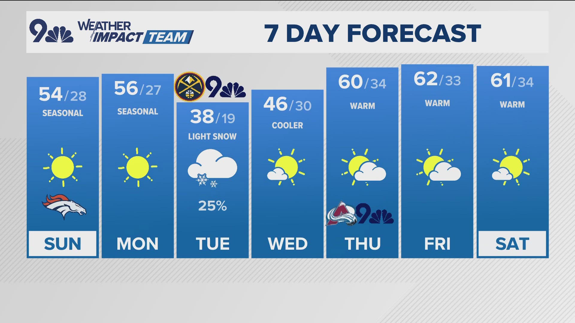
No other strong storm signals in the 10-day forecast. Sunshine will return on Thursday just in time for Halloween, but the cold dense air will still linger. Could be one of those very sunny and cold days. Guidance is still suggesting the daytime high will be below 40 degrees, with it into the 20's by sunset.
SATURDAY UPDATE
Oct. 26-28
This will be the last entry in this feed. I'll start a new blog for Tuesday's storm. Here is the storm timeline. I use the Denver metro as a reference point so I don't have to spend 8 hours writing up other locations. Timing will be a little earlier to the north and later to the south.
COLD FRONT: This will be a sharp front moving in between 7 to 8 p.m. tonight. Probably not as violent as the one a couple weeks ago, but it should kick up some winds and dust. Temperatures will drop from near 70 degrees at 5 p.m., to the 40's at 10 p.m.
FIRST PRECIP: Scattered showers should begin around 10 p.m. as snow in the mountains and rain on the plains. This might not last long as temps drop down into the 30's after 10 p.m.
FREEZING RAIN: This is not likely on the plains because temps will be too high, but in the higher foothills, there may be a layer of warmer air just above the surface that could melt snow and refreeze when it hits the ground. It should't take more than an hour or so to work that warm air out.

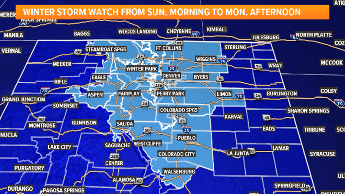
FIRST SNOW: Should see flakes in the metro by midnight with temps between 33 and 35 degrees. These first flakes should be light in nature and melt when they hit the ground.
FIRST ACCUMULATION: Temps should hit 32 degrees around 2 a.m., and snow will start sticking to the grass, and rooftops. Snow should remain very light for the first few hours.
STICKING TO THE ROADS: Due to the light nature of the snowfall, it might take a few hours at below freezing temps to stick to the roads. This should start to happen around 6 a.m. Snow should be light thought until after 10 or 11 a.m. I would expect about an inch on the grass by noon.
Snow should start sticking to mountain roads by 2 a.m. Light in nature up there at first as well.
HEAVIER SNOW: It should gradually pick up in the rate of snowfall after 10 a.m., but the best snow should occur in the late afternoon and evening hours. Travel will start getting pretty tough in the metro by about 4 p.m.
MONDAY MORNING COMMUTE: This will be the most difficult time period during this storm. Snow will probably be heaviest overnight and last into the commute, not clearing out until after 10 a.m. Temps should be in the upper 20's during the commute.

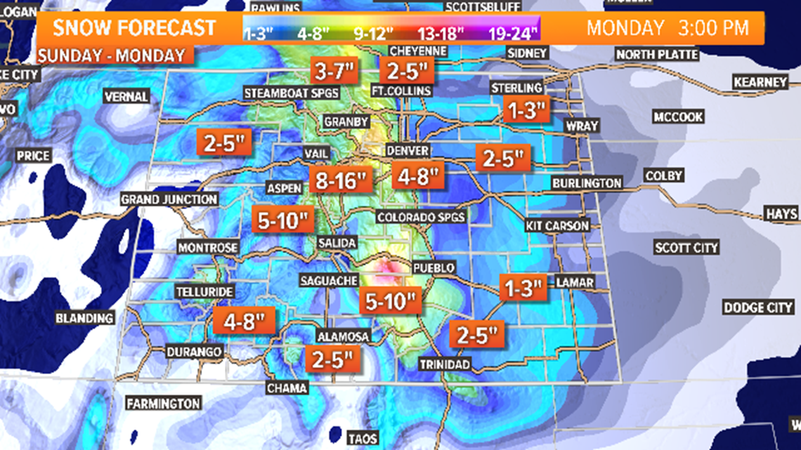
SNOW TOTALS: The Denver metro has the potential to get more than 6 inches of snow, which is pretty unusual for us. We usually only go over 6 inches a couple of times a year. We have been keeping the forecast for between 4 to 8 inches, and I still think that is the most probable range. Lower totals to the east and northeast of Denver.
Since the driving force for snowfall with this storm will be upslope winds, expect the most snow in the foothills between 6-12 inches, and a little less as you go west of the Continental Divide.
The Palmer Divide should do well with between 6 to 12 inches. The 12 should be in the Douglas County foothills and the Monument Area, 4 to 8 along I-25. And 3 to 6 in Colorado Springs.
I-25 north of Denver will get snow. Between 4 to 8 from Firestone to Ft. Collins. 1-4 on the plains, except the areas closer to the foothills like Byers, and Greeley could get more than 4.
Chance of snow in Denver: 100%
Oct. 29-30
I feel that the second surge of polar air may be more impactful than the first. The reason I say that is temperature. The ground will have been below freezing for nearly 48 hours when the next snow comes in, and there is an indication that it could be just as snowy as the first storm.
Current timing is from the Tuesday morning commute lasting all the way through the Wednesday morning commute. models are still showing an additional 4-8 inches, which means if Denver could get more than a foot of snow between the 2 storms.
The second storm should also bring widespread snowfall including the mountains and eastern plains.
Chance of snow in Denver: 65%
Halloween
Still looks clear and dry for Halloween, although this cold air is likely to still be around. The high temperature that day is being shown below 40 degrees, with 20-degree temps during Trick-or-Treating.
FRIDAY UPDATE
Oct. 26-28
A big push of arctic air will descend on Colorado and stick around for several days. It is very possible the temperature in Denver will stay below freezing for four consecutive days, Sunday-Wednesday. The Tuesday-Wednesday part of the storm will be addressed separately (below).
The first noticeable part of this system will be a powerful cold front that will press through quickly on Saturday night. That should kick up strong winds and drop temperatures rapidly, and could hit Denver as early as 6 p.m. on Saturday evening.
The precipitation will probably be a few hours after that. It is possible there will be a few rain showers initially with the temps predicted to be in the upper 60s during the day, but with as dry and cold as the air will be, it could turn straight to snow.
This is a frigid arctic air-mass, so there's not too much moisture in it. With such cold temperatures though, it should be able to wring out all of what is available.
It's possible there will be snow accumulation before midnight, but most of it will come on Sunday. It will probably be lighter and smaller flakes this time around, but there will be accumulation on the roads with those temps.


Both the Euro and the GFS show 4-6 inches in the Denver metro by Monday at noon. That is a really good agreement. So far, the NAM is coming in with a little less, but that is normal.
That is not much accumulation for more than 24 hours of snowfall. That kind of gives you a hint about the character of the snow: lighter rates with smaller dry crystals.
With cold temperatures, that increases the snow-to-water ratio, so that gives us higher potential. With the potential for up to 8 inches in some spots, that may prompt some Winter Storm Watches later tonight.
Chance of snow in Denver: 85%
Oct. 29-30
Before the first wave of cold air has moved out, a second surge will be coming down from the north right behind it. This is where the computer models stop agreeing with each other.
GFS has only low impact, with snow starting up again Tuesday morning and going until Tuesday evening, dropping another 1-3 inches of snow in the Denver area.
The Euro has another good dose of snow and has been trending up lately. It shows the snow starting back up late morning Tuesday and lasting all the way until early Thursday morning at about 3 a.m., with an additional 4-8 inches of accumulation. It also shows a more significant impact to the mountains and plains.
Inconsistencies and disagreements between models is not a strong forecast signal, but they both have been showing some additional snow in Denver, so plan on that second wave being likely.
Chance of snow in Denver: 55%
Halloween
With this polar outbreak, the Halloween night forecast continues to trend cold. It looks like there will precipitation. Both models are showing sunshine for most of the day with highs in the mid to upper 30s, which would mean trick-or-treating in the 20s. Winds will be steady but light.
THURSDAY UPDATE
Oct. 26-30
The jet stream is reloading and already has another target pointed at Colorado. There is still some disagreement among the computer models about how this thing is going to unfold. You may have noticed some erratic behavior on the 10-day forecast of your favorite weather app.
It does look like there will be a double surge of polar air — the question is mostly about timing and duration with the first one, and track with the second one.
The models are slightly different still, but starting to come into alignment.
The GFS has a cold arctic front arriving in the Denver area late Saturday night, with snow quickly accumulating just after midnight. There will be much colder temperatures with this one, so rain and melt will be much more limited compared to our most recent storm.
It shows snow lasting through the day on Sunday into Monday morning with 1-4 inches of accumulation in the Denver metro area.
Then, with the second surge, it shows about a 24-hour break before more snow starts falling on Tuesday morning with 1-3 inches by noon Wednesday. The GFS has been trending towards the Euro on this solution.

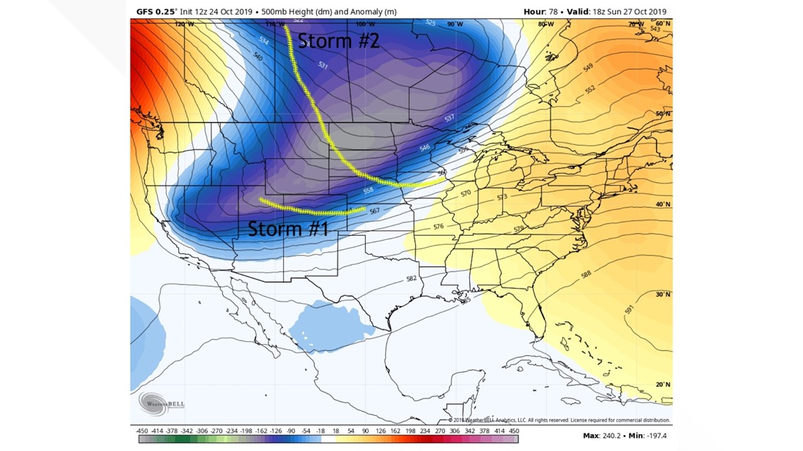
The Euro has a similar timing with the first front.
It shows it coming in late Saturday night and dropping 2-5 inches of snow in the metro through Sunday and into Monday afternoon.
Then it has the next storm front arriving less than 24 hours later, with snow on Tuesday morning and lasting all the way until Halloween morning with another 2-5 inches.
The NAM, which is a mesoscale model (shorter-term), has just come in range of the first storm system, and it shows the front coming in around 9 p.m. Saturday, with snow starting in the metro around 10 or 11 p.m.
The models have been very consistent and unanimous with the first front, but not with the second. I will probably separate the storms in Friday's update even though it may end up feeling like one long wintry storm. The projected path of the second storm is in a position that frequently misses Colorado.
I would definitely expect more snow this weekend. It's reasonable to say it will start sometime late Saturday night, lasting at least through the day Sunday.
Chance of snow in Denver: 55%
Halloween
Both models show Halloween day and night as clear and dry for now, but very cold and windy. With snow in the days leading up, there will likely still be quite a bit of snow hanging around, maybe even on the sidewalks.
There are no consistent systems showing beyond 10 days.
SUGGESTED VIDEOS | Science is Cool


