COLORADO, USA — This snow blog watches winter storms develop in the long range computer modeling up to 15 days out and gets updated once per day. This feed will go until the mid month storm is finished.
Tuesday Update:
Feb. 12-13
Quick winter storm moves through Colorado on Wednesday morning. Doesn't look like there will be any advisories for this one as the potential is low in both the mountains and the plains.
Could start snowing in the metro by about 10am but probably wont accumulate for a while. The most widespread snow is from 2pm to midnight. Looks like we are looking at about 1-3 inches by Thursday morning. Should stop snowing in the metro by about midnight, and clear out of the rest of the state by Thursday evening.

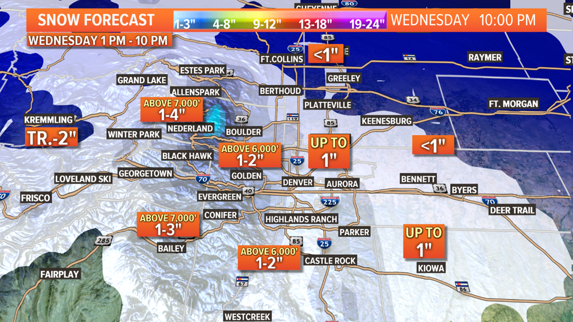
Most of the I-25 corridor, eastern plains, and Palmer Divide also only have a 1-3 inch potential with a few isolated spots getting more than 3". Pretty much the same for the foothills, but with a few more areas there with the potential to go over 3".
The mountains, favoring the northern areas, will be in the 2-4" range with very few spots having the potential for 6".
Complete bust potential is there but very low, most of Denver should at least get some accumulation.
Chance for snow in Denver: 85%
Feb. 15
A storm system will sweep by to the north of Colorado on Saturday. May cool us off and bring the mountains a chance for a quick dusting. Snowflakes in the metro look pretty unlikely.
Chance of snow in Denver: 5%
Feb. 16-18
Timing has changed a bit with this one, but it's gaining momentum for some significant impacts to the Front Range and eastern plains. The Euro shows a storm system diving down into southeastern Colorado which usually means strong north winds and snow on the northeastern plains.
It shows next Monday as the most likely time for this to go down.
Chance of snow in Denver: 10%
Feb. 19-20
Quick little southern storm track right behind Mondays storm may bring some light impacts to parts of Colorado.
Chance of snow in Denver: 0%
Feb. 21-23
This will likely be the final storm in this very active period. After this, the timing in between storm could become a little bit more normal. Actually get a few warm off days in between storms.
Feb. 25-27
One storm showing in this window for now with low impacts.
--------
Monday Update:
Feb. 10-11
A few heavy bands are showing up in the south metro at the time of this post but the majority of the air mass over the Denver metro is still a little to dry for snow. This will happen over the course of the evening.
The air is coming in with a little more moisture in it than models showed yesterday, and the snow could last a little longer as well. Some models are showing it lasting until about 3 or 4 am in the metro.
The main concern will be for heavy blinding type snow during the evening commute, with snow accumulating on the roadways after dark. Morning commute will be cold and icy but not much snowfall if any.
The overall accumulation number will probably be a little higher. Maybe a 1-4 inch spread across the metro, and the higher totals to the south of Denver. The National Weather Service has put up a Winter Weather Advisory in response to these changes.
Feb. 12-13
Another quick and weak system moves in on Wednesday. Not too much in the mountains but the Front Range and the plains will have a brief chance to pick up some snow.
For the metro area, the best chance for snow will likely be Wednesday evening, ending before Thursday morning. Accumulation looks a little better for the metro with today's models. 1-2" in most of the area, but 2-4" possible in the southwest and south metro.
Sadly, the potential for getting more than 2 inches on the plains is trending downward.
Chance of snow in Denver: 45%
Feb. 15
This system is sending a strong signal but so far looks like it will miss Colorado well to the north, so just a slight chance of some snow on the Front Range.
Potential for about an inch as been shown lately.
Chance of snow in Denver: 5%
Feb. 16-18
These two systems moving quickly upon each other are showing some good potential today for some more metro snow Monday into Tuesday. Timing and consistency has changed a lot, so not high confidence yet.
Chance of snow in Denver: 5%
Feb. 21
GFS shows a quick storm on this Friday with some possible light impacts to Denver area.
Feb. 21-26
Strong ridging may develop and put an end to our active weather, but it will warm up nice for those who don't like this wintery stuff.
--------
Sunday Update:
Feb. 10-11
Quick burst of winter energy coming again on Monday will bring some more snow to the Front Range. It looks like it will be starting just after noon and last until about midnight.
The best probability is mostly between 1 to 2 inches. That includes the Denver metro area and the rest of the Interstate 25 corridor between Cheyenne and Colorado Springs.
There is a little more potential to the south of Colorado Springs. Maybe 2 to 4 inches of snow is possible between Pueblo down into New Mexico.
Parts of the foothills could go over 2 inches as well.
Some parts of the Eastern Plains could get up to an inch.
Expect light snow in the mountains, mostly less than 2 inches, except in southern Colorado, where just a little more potential exists.
Chance of snow in Denver: 40%
Feb. 12-13
Another quick and weak system moves in on Wednesday. Not too much in the mountains but the Front Range and the plains will have a brief chance to pick up some snow.
For the metro area, the best chance for snow will likely be Wednesday evening, ending before Thursday morning. Accumulation looks to mostly be less than an inch though, with only a few select spots going over 1.
Since the impulse is mainly to the northeast of Colorado, that means the eastern plains will have a chance to get more than an inch. Those spots will be limited and likely along the Kansas/Nebraska state line.
Chance of snow in Denver: 25%
Feb. 14-15
This system is sending a strong signal but so far looks like it will miss Colorado well to the north, so just a slight chance of some snow on the Front Range.
Potential for about an inch as been shown lately.
Chance of snow in Denver: 5%
Feb. 16-18
In today's GFS runs, it showed two systems with some decent potential for the mountains, but not much on the Front Range.
Feb. 21-25
GFS shows a couple storms near Colorado with little impact.
--------
Saturday Update:
Feb. 8-11
Cold front is just starting to bring some snow to the northern parts of Colorado tonight. Some parts of the Front Range could get a little accumulation before midnight, but most of it will fall Sunday.
There is a Winter Weather Advisory out for the central and northern mountains with this storm. Mostly 3-6" possible, with 6-10" inches on some of the passes and ski areas.
The Denver metro area is looking at another 1-4" by tomorrow night. Westside will likely be the areas closest to 4".

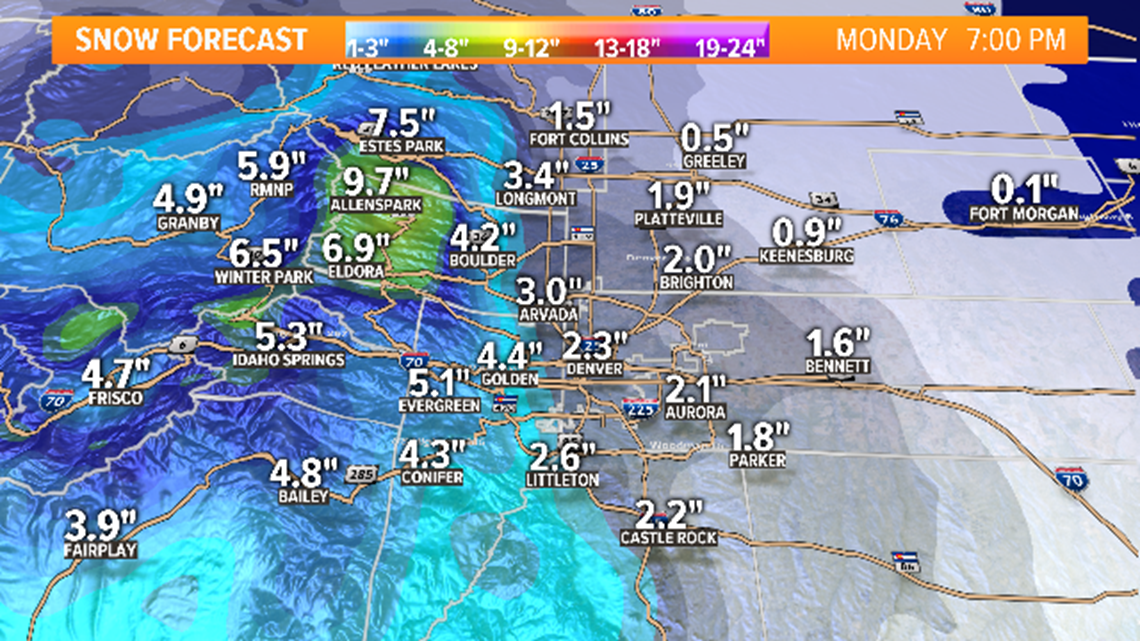
Some of the foothills could get between 3-6". Peak-to-Peak corridor looks to have a bit more potential.
Palmer Divide and Colorado Springs is in the 1-4" with areas to the west of I-25 with the most potential.
Some of the eastern plains will see some snow. Mostly 0-2 inches of accumulation with the higher amounts to the west and close to the Palmer Divide.
There will be another quick burst of snow on Monday evening associated with the splitting system. Looks like up to 1 inch will be possible on the Front Range
Chance of snow in Denver: 95% (Sunday and Monday)
Feb. 12-13
There will be a couple chances for some snow on the Front Range and eastern plains on Wednesday and Thursday but accumulation looks unlikely at this point.
Chance of snow in Denver: 15%
Feb. 14-15
This system looks like it may still have some impacts to Colorado, however minimal. Snow looks possible in the Denver area next Saturday. 1-2" showing so far.
Feb. 16-18
This storm system showed up in the modeling again today with an indication for some snow in Denver on Sunday, and then again on Tuesday.
Feb. 20-24
GFS shows a ridge building in with the return of some warmer and drier weather in this time-frame. It does show one storm moving to the north of Colorado but too far away for any impact.
--------
Friday Update:
Feb. 8-11
No rest for the weary. Another storm is inbound to Colorado. This one will split in two before reaching the state tomorrow night, but still bring some snow to the mountains and the Front Range.
The front actually arrives on Saturday evening, and could bring some snow to the I-25 corridor between Cheyenne and Denver before midnight. Same with parts of the foothills.
Most of the snow will be behind the front though. Mountains looks to be in the 3-5" range with a few spots close to 8 inches.
Snow in the Denver area and most of the Front Range will mostly be between about 1am and 11am Sunday morning. Spread looks to be between 1-4 inches with the higher totals to the northwest part of the metro.
Foothills mostly in the 2-5" range will a few spots a little higher. Euro likes Boulder County.
0-1" on the plains and El Paso County, with less to the east. 0-2" on the Palmer Divide.
I'm guessing no advisories with this storm.
Then a slight chance of some flurries on Tuesday morning.
Chance of snow in Denver: 55% (Most likely Sunday)
Feb. 12-13
Little bit more consistency with this storm. Quick snow in the mountains and 1-2 inches of snow being shown for the Denver area.
Chance of snow in Denver: 25% (Most likely Wednesday)
Feb. 15-16
This system is still showing in the models. It has been indicating a chance for snow in the Denver area next Saturday. 1-2" showing so far.
Feb. 17-18
A storm system possible here with snow for the metro and plains. First day showing this organization.
Feb. 20-23
GFS shows a system in the area in this time-frame. Not much impact for Colorado at this time.
--------
Thursday Update:
Feb. 6-7
Pretty cool little snow storm we have on our hands today and tomorrow. There is virtually no mechanism to create snow showers other than some convergence below the jet stream, and some very powerful jet streaks embedded in that flow.
So it's all about banding with this event. That can create some extremely heavy snow, but in highly localized areas, and it's very hard to tell if those bands will drift either east or west at all.
So we are left with this situation of just relying on the best probability, which is a slight shift west tonight and especially Friday morning. There is also a good chance that additional bands develop to the west at some point as well.
This leaves the Ft. Collins area and the Greeley with the highest chance to get the highest snow totals on the lower Front Range. Most likely in the 3-6" range, unless they get centered up with a long lasting band, and then sky's the limit really.
Those bands can add an additional 3-6" in short order. Just have to go with probability and hope that one doesn't move right over your city. Or hope depending on what type of person you are. A good 2 inch per hour snowfall rate can be really exciting.
The Denver area is also included in the advisory. Must less of a chance to catch one of those super bands, but some form of banding could develop here as well. I do believe that will happen at some time tonight or tomorrow morning. That would keep us most likely in the 2-4" range around the metro. A bigger band could add another 2-4" but again, the probability is too low to include that in the spread. There is actually a higher chance of getting less than 2 inches than more than 4.
Still high potential for a slow commute. Even if we only get in the 2 inch range, and the National Weather Service cancels the advisory there early.

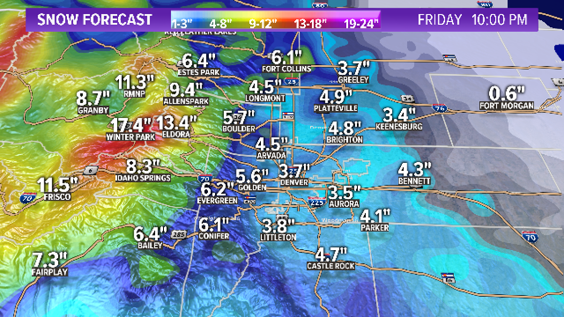
Some increasing snow being indicated for the lower foothills below 7,000 feet. Still keep the 3-7 inch spread, but better chances I would say of getting to the higher end of that spread. 8-14" in the higher foothills above 7,000 feet.
Mountains have the Warning. The mountain passes will be dangerous tonight and most of the day Friday.

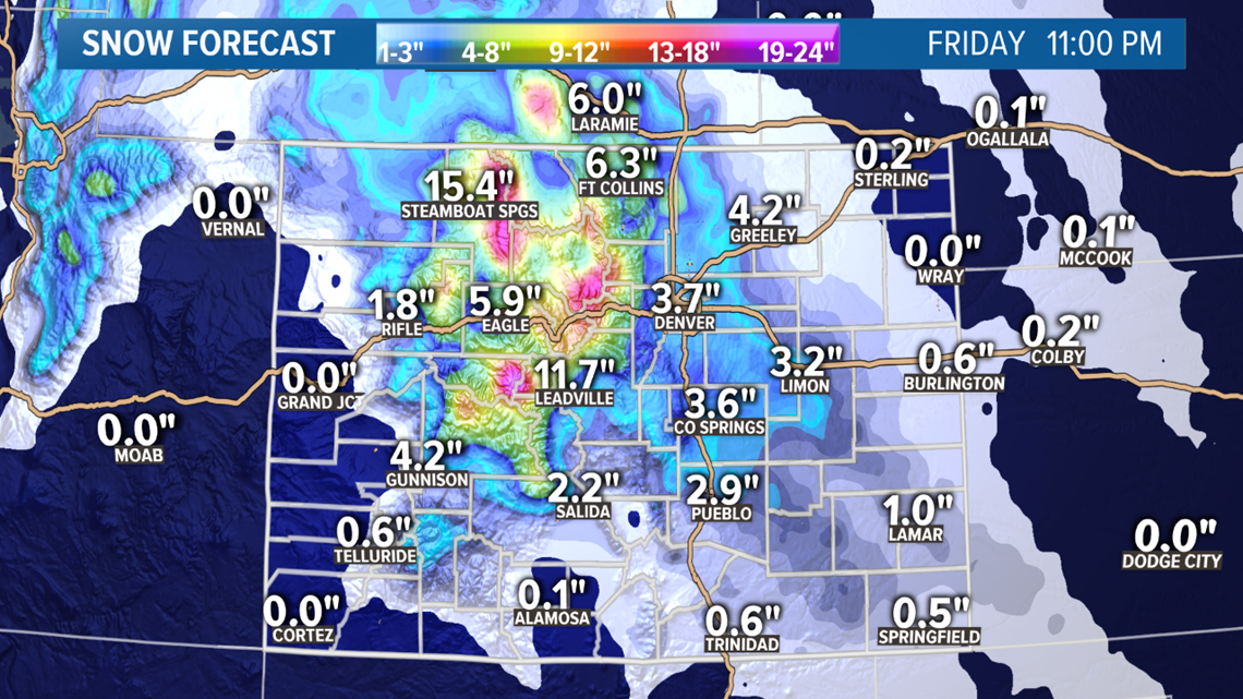
Probably keep the 2-4" spread for the Palmer Divide. Banding not as likely there, but the topography will help in some spots there. Colorado Springs will get some more snow tomorrow too. Still in the 2-4" range there.
Feb. 8-10
This system remains unchanged in todays model runs.
Looks like maybe 3-6" in the mountains and 1-3" in the Denver metro area. Denver's snow would be on Sunday. Modeling most shows less than 2 inches though.
Chance of snow in Denver: 35% (Most likely Sunday)
Feb. 12-13
The look of this storm has changed quite a bit in today's modeling. The chance for snow with this system on Wednesday is trending downward.
Chance of snow in Denver: 15% (Most likely Wednesday)
Feb. 15-16
This system has picked up momentum where the previous storm left off. It is showing more impact to Colorado with a chance of snow in Denver next weekend.
Feb. 17-22
The GFS also flip flopped on this time frame. The last couple days, it had indicated that a storm on the 19th would be the end of this active stretch, but now it is showing a couple more little chances towards the 21st and 22nd.
--------
Wednesday Update:
Feb. 6-7
Very interesting storm just moving into the state tonight. With jet stream support, this will deliver big snow to the high country, and some heavy snow banding on the plains.
A Winter Storm Warning has been issued for the central and northern mountains where some locations could get more than 2 feet of snow, and a few spots could get 3 feet. Mountain travel will be difficult all day Thursday and Friday.

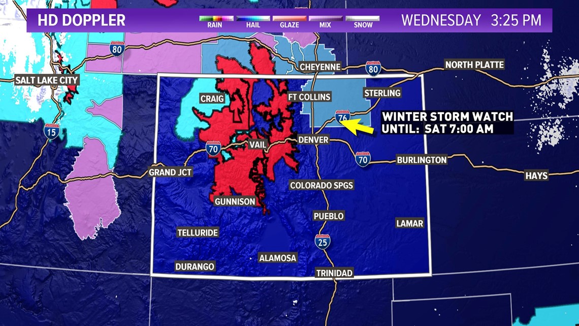
A Winter Storm Watch is in place for Weld, and Morgan Counties, as well as the lower portions of Larimer County. This is due to the likelyhood of a NW to SE oriented snow band developing and remaining fairly stationary for a good part of the day Friday.
Before that happens, there will be some other upslope snow on the Front Range starting Thursday. The first action could be down in the Pikes Peak Region or parts of the Palmer Divide just after sunrise tomorrow.
That will gradually spread out and involve the northern part of the Front Range. Look for snow to start accumulating in the Denver area sometime after sunset Thursday.
The metro area will likely end up in the 2-4 inch range of accumulation. That snow will likely continue on through the day on Friday, so there is a high potential for the Friday morning commute to be very slow.
The foothills are in the 3-6" range in today's modeling. The Palmer Divide and Colorado Springs is in the 2-4" range.

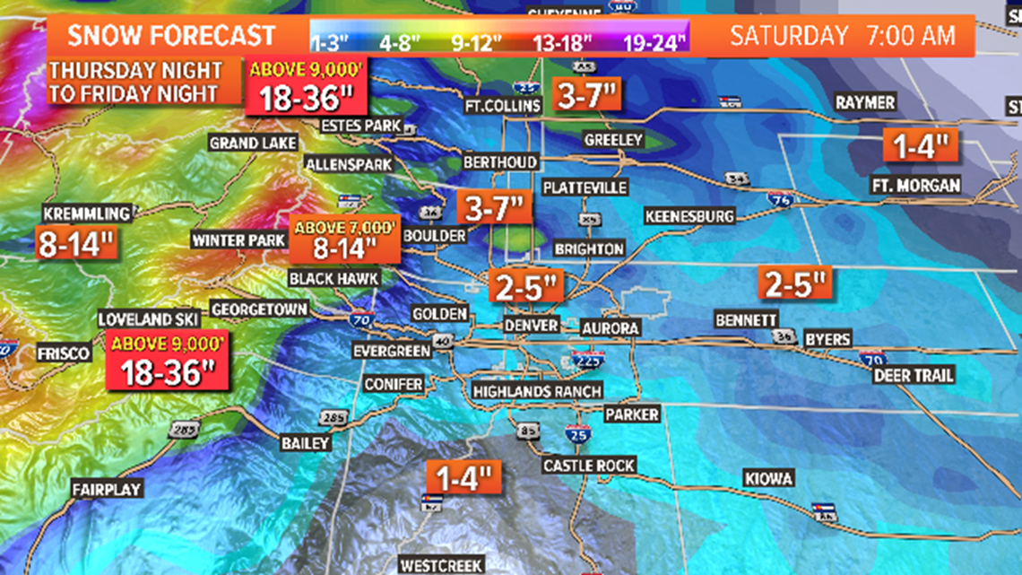
The most interesting feature with this storm will likely be a heavy snow band setting up to the northeast of Denver on Friday. There still is a chance it comes down to Denver, and if it does there will be a few more inches in that area, but for now there is a good chance it stays out of the metro.
That band is the reason that Ft. Collins, Greeley, and Ft. Morgan could get a Winter Storm Warning issued soon. There is the potential for up to a foot of snow if this band sets up just right. It is also possible that it doesn't move very much. If that happens you could get a scenario where north Greeley gets 10" and south LaSalle gets 4". That is the type of band this could be.
For the most part, those counties will probably fall in the 3-6" spread, with just a few lucky spots getting more than 6". There is of course a chance that the beefy part of that band sets up right over top of one of those cities as well.
Either way, there should be some sort of snowfall up there from Thursday night to Friday night.
Chance of snow in Denver: 90%
Feb. 9-10
This system looks like it may split Colorado in half, with one piece of vorticity staying to the north and the main piece going to the south. If that happens, it will likely not have too much impact on our state.
Looks like maybe 3-6" in the mountains and 1-3" in the Denver metro area. Denver's snow would be on Sunday. Modeling lately has been showing less than 2 inches possible.
Chance of snow in Denver: 25% (Most likely Sunday)
Feb. 11-14
A very active storm patter will continue for us here in Colorado. This looks to actually be two storms moving through in short order.
That could deliver a significant hit to the mountains especially the San Juans with the first southern storm track.
GFS is still indicating a few inches of snow in the Denver area on Wednesday.
Chance of snow in Denver: 20%(Most likely Wednesday)
Feb. 15-16
This trailing storm is the weakest signal of the bunch. There is an indication for some light mountain snow though.
Feb. 17-19
This system may likely be the last storm in this long stretch of active weather. It doesn't show any impacts to the Front Range, but more snow in the mountains is likely. This could end a 14 day stretch of at least some snowfall in the mountains every one of those days.
--------
Tuesday Update:
Feb. 5-7
There won't be much of a break between winter storms in Colorado this time. The next one moves into northwest Colorado tomorrow night.
There isn't really much of a disturbance, it's just a very small shortwave, but the a screaming jet stream will move over northeast Colorado, and that means banding.
That means the ceiling will be much higher than the actual probability. This often bust over. There isn't too much moisture available though, so this one may actually be inside the forecast spread.
This will bring 8-16 inches of snow to the northern and central mountains. A Winter Storm Watch is in place. Travel in the high country will be quite difficult all day Thursday and Friday.
There will be a few chances for snow down low as well, starting Thursday morning. This will not impact too many areas. Probably just the Palmer Divide, and parts of Teller and El Paso Counties. Less than an inch likely.
Then later on in the day as the best upslope moves underneath the strongest upper air support, a large band will develop with a northwest to southeast orientation. From Thursday evening into Friday night will be the snowiest conditions.
This is a good setup for Ft. Collins and Greeley as it looks like they are in the 3-6" spread for now. Areas to the north of Denver will carry the best chance for more snow.
It looks like that banding will make it to Denver as well. So far we are in the 3-6 range just like the last storm with most of us getting 4's and 5's. Potential for trouble is building for the Friday morning commute.
Parts of the foothills will have big potential again as well. Likely in the 6-10 range, especially Jefferson and Boulder Counties.
Chance of snow in Denver: 45%
Feb. 9-11
After a short break on Saturday, another storm system is likely to impact Colorado. This storm to the northeast of the state will likely kick of a long lasting series of storms that may come one after the other for several days.
This first one may not have much impact to the Front Range, but could deliver some snow to the mountains. Models have been showing some snow in the Denver area on a few recent runs.
Chance of snow in Denver: 15%
Feb. 12-14
Two more swirling low pressure systems are likely to follow. GFS is showing snow in Denver all three of these days. Totals are not huge right now, but it looks like one of the lows is flirting with the sweet spot in southeast Colorado, so lets watch it develop.
Chance of snow in Denver: 15%
Feb. 15-16
Another trailing storm could bring some more light impacts to Colorado in this time-frame.
Feb. 18-19
And then one more storm system to round off this active stretch of weather in Colorado. It doesn't look that impactful but there is an indication for snow in the Denver metro with this one.
--------
Monday Update:
Feb. 4
There are still quite a few heavy snow bands tonight stretching from the foothills all the way to the Nebraska state line, but there is a lot of space between those bands. That behavior will probably persist until about 2am on the Front Range
We then lose the high potential for strong bands, but the snow will not end. It will be around in northeast Colorado all the way past sunset Tuesday. It will be much more broken and scattered after about 10am though.
I think the morning commute tomorrow will be very slow. Roads will be very icy with temps close to single digits. The snow will only be light to moderate though, so not too much more accumulation after about 8 or 9 am.
Feb. 5-7
The next storm will move down just to the northeast of Colorado by Wednesday night. This could bring another 6-12 inches of snow to the mountains but not as much impact to the Front Range.
Looks like there may be several chances for some snow in the Denver area. Thursday night into Friday morning, and then again Friday night looks like the best chance right now.
This is a very northern storm track, so areas to the north of Denver will have the best chance for snow. Like maybe 1-3" in the Denver area, and 2-4" to the north of there.
Chance of snow in Denver: 30%
Feb. 9-11
This is the first in what is being shown as a series of storms. Decent snow for the mountains but minimal impact to the metro being shown. This is however another day of model runs that shows at least a couple inches of snow in the Denver metro.
In today's runs it is showing Sunday night into Monday morning.
Chance of snow in Denver: 15%
Feb. 12-17
This window is still being shown with several different surges of cold northern air moving into Colorado. While the GFS has been very inconsistent on the timing and character of those storms, it has been sending a strong signal for snow in the Denver area for 3 days in a row now.
I don't expect this solution to hold, but it does make me think there is at least 1 good storm coming down the pipe in this window. Right now the GFS shows snow in Denver on 3 of those days, but only totaling 1-4 inches all together.
--------
Sunday Update:
Feb. 3-4
This winter storm will be a great shock to our systems in northeast Colorado tomorrow. After not having to deal widespread winter driving conditions since late November, and just for the simple fact that we don't get storms very often that carry the potential for 6 inches of accumulation in such a big portion of the Denver metro.
The biggest mistake people that haven't experienced winter storms in the metro make, is focusing on total amount of snow accumulation. The important information is what is the fastest rate of snowfall, and when will those biggest rates occur. That is when driving a vehicle is most difficult.
The cold front will likely arrive sometime after sunset or maybe even after the Superbowl trophy is raised down there in chilly Miami. The temps will start plummeting from there but the snow won't be a huge impact right away.
Snow should start to pop up around the Front Range sometime after midnight, and maybe even in the Denver metro before 4am, but that first bit will probably be fairly light, and melt to the roads initially, so the Monday morning commute will likely not be too troublesome. Getting back home however, may be a different story.
There is a possibility of 2 inch per hour snowfall rates setting in sometime after noon. If not 2"/hour, 1 to 1 and a half can shut down roads pretty easily. Timing is estimated to be a little different with each model but the best time to be off of the roads would be by 3 or 4 pm. Even if you are a great winter driver, the roads may be too packed for you to get around well anyway.
The snow will start to let up a little after 10pm, but then we have a high potential for heavy banding on Tuesday morning. Either way, there will still be some snowfall in the metro for the morning commute, so that will be very slow. There is a chance that the heaviest bands miss the metro Tuesday morning, but due our topography, we usually do get them in this setup.
Storm should clear out by about midnight so Wednesday mornings commute will at least be free of snowfall. It will likely be in the single digits though for temperatures so still could be pretty slow.
And then there's everybody's favorite topic (including mine), how much snow?
There is widespread potential for 6 inches of snow in the metro with the highest odds to the west of I-25. Models have not shown a single 2 inch reading in the last 2 days of modeling, so I think we can eliminate that number from the lower end of the spread.
It's looking like there will be a lot of 4 and 5 inch totals with 6 and higher to the west side. Since there are quite a few 3 to 4 inch totals showing on the east side, maybe put the final spread in the metro at 3-6 inches.
Snow is never uniform in Devnver, so what that means is that the majority of locations will likely fall inside that spread, and less locations will go over and below that spread.
A Winter Weather Advisory has been issued for most of northeast Colorado.
The GFS is showing a high potential for 6-10 inches in the metro, but you know my policy by now, if the Euro doesn't bend I don't bend. If the 18z Euro comes up, I will certainly have to make last minute changes to my expectations.
With most uplsope storms, the foothills of Larimer, Boulder, Jefferson, and Douglas Counties have higher potential. I would not be surprised to see a few 12 inch totals there, but that is not always uniform either so go with a spread of 6-12" in those foothills. Looks like a little less potential for the southern foothills like Teller and El Paso Counties.
There is less potential on the Palmer Divide as well. Looks similar to the metro to me with a spread of 3-6 inches. I normally consider the Palmer Divide as being east of I-25 except all of Castle Rock, while areas to the west of I-25 are the Douglas County foothills where there is higher snow totals.
As usual, the totals for the eastern plains have come way down. There may be a pocket of banding out there somewhere that can get you up over 3 inches but it looks like mostly a spread of 1-3".
There is a Winter Storm Warning in place for most of the foothills and the mountains as well. Looks like between 6-12 inches in the high country as well. Tuesday morning will probably not be too bad as far as driving on I-70 but after about 10am it will start to get bad.
Feb. 5-7
There will be another storm system moving in to the northeast of Colorado before this storm even moves out. That will bring a few more chance at some snow in the Denver area.
In the latest modeling, it's looking like Thursday morning, and again on Friday night. Looks like 1-3 possible between both doses, but could be another significant event for the mountains.
Chance of snow in Denver: 20%
Feb. 9-11
This system is trending closer to Colorado in todays runs. GFS shows a storm diving down to the west of Colorado and then moving into the southeast corner bringing the Front Range a chance for some more snow.
That would bring some heavy snow to the San Juans as well.
Today's runs were the first to show a significant impact to the Denver area though. We'll have to see if that continues to hold.
Chance of snow in Denver: 10%
Feb. 15-17
Several storms showing in this window again today, with some impacts to the Front Range. Nothing significant, but it is the second day in a row with at least some impacts in this window.
--------
Saturday Update:
Feb. 3-4
Computer models continue to show a fairly unorganized storm system forming around Colorado with a piece of vorticity moving up from the southern branch of the jet stream, and the main piece of vorticity diving deep to the south.
There will be a considerable amount of cold air pressing in though, so most of the moisture will be able to get rung out of the atmosphere.
Still looks like a little surge of upslope very early Monday morning creating mostly light snow showers on the Front Range. The cold front moves in on Sunday night, probably well after sunset.
Morning commute shouldn't be to bad with lighter snow and some initial melting. There may even be a break in the snow mid day before the heaviest snow sets in in the evening.
Monday evening an night will be difficult to drive. The snow likely continues into Tuesday morning, so that commute will be very slow.
It's a dry air mass so not a ton of snow accumulation. Still looks like the majority of the metro is in the 2-4 range, with the areas west of I-25 coming closer to 6 inches. I think there will be more 6's and 1's with this event.
Chance of snow in Denver: 80%
Feb. 5-7
This system has been trending down in snow totals for the mountains but still could be looking at 4-8 inches in spots It does still show a chance for light snow in the Denver area.
Chance of snow in Denver: 15%
Feb. 9-11
This system is showing as a southern Colorado storm with some light impacts possible in the Denver area. It should must more of an impact on Monday in yesterdays runs than today.
Feb. 13-17
Several storms showing in this window. It does show a snow possibility for the Denver area on Thursday Feb. 13 but nothing significant.
-------
Feb. 3-4
We are on track for a pretty impressive snowstorm on the Front Range starting Monday morning. We aren't expecting the largest totals: mainly between 2-4 inches with some areas closer to 6. But with the low temperatures expected, there will be several moments of trouble on the roadways.
It should move in very quickly on Monday morning. Snow will likely be falling between Cheyenne and Denver before the sun even comes up. Even with the warm Sunday temperatyres still absorbed into the ground, snow will likely start sticking right away.

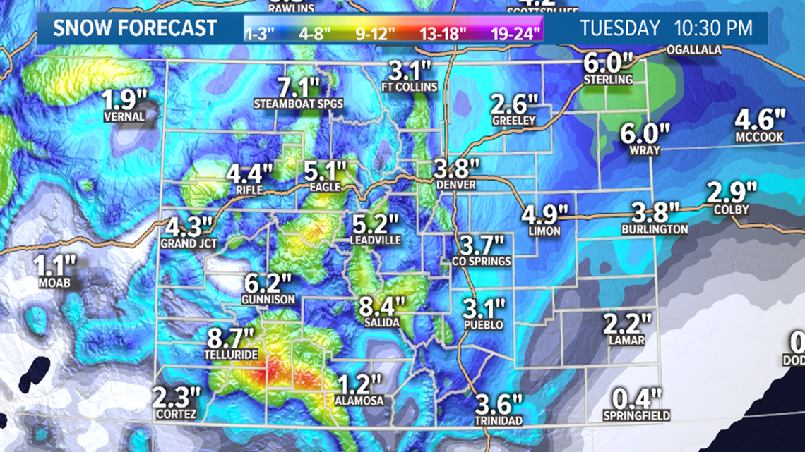
I don't feel the Monday morning commute in the metro will be too bad though, mainly because of the lighter nature to the first bit of snowfall. There will also be some melting on the roads initially. That is what the timing looks like now anyway.
Right now, models are showing the heaviest snowfall between 5 p.m. Monday and 1 a.m. Tuesday, so driving will be most difficult on Monday night. Tuesday morning will likely still feature some light snowfall in the metro, so that morning commute will be very slow.
The main snow totals are will be between 2-4 inches in the metro, 3-6 inches in the foothills, 2-4 inches on the Palmer Divide, and 2-4 inches on the eastern plains. The Euro is still showing a heavy of 3-6 inches in the northeast corner so that's something to watch for.

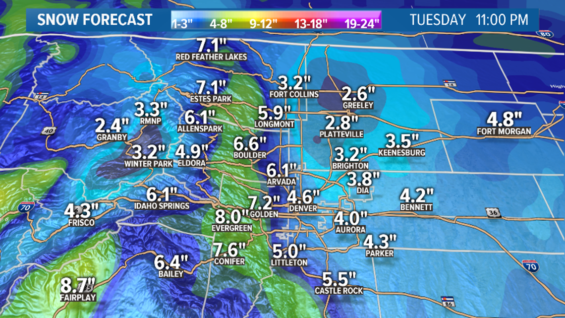
We are looking at about a 10:1 snow to water ratio with these temps, which is great because that is what the computer models output. What you see is what you get.
Mountain travel will be difficult all day Monday and Tuesday morning. We will probably get some winter storm warnings down in the San Juans where more than a foot is possible.
There will be heavy snow in the central mountains as well. Models have come down a bit in the northern mountains but I would still expect about 8 inches at Steamboat Resort.
Chance of snow in Denver: 70%
Feb. 5-7
Another system moves in just to the northeast of Colorado on Wednesday. Could bring some more significant snow to the mountains. Models are also showing another dose of snow in the Denver area. Not as widespread as the first storm, but there are indications of 1-3 inches in some areas.
Chance of snow in Denver: 15%
Feb. 9-11
A very active pattern conitues for the first 15 days of February. Models show this next storm with some possible impacts to the metro area. So far it looks like Monday Feb. 10.
Feb. 13-16
GFS shows two more storm systems moving in during this window. So far no impacts to the Denver area are shown.
--------
Feb. 3-4
The first system of the month moves in right after an unseasonably warm Superbowl weekend. It will actually be a couple surges of cold Canadian air at just about the same time.
The Euro has one piece diving south just to the west of Colorado, while another piece ejects across the middle of the state from southwest to northeast.

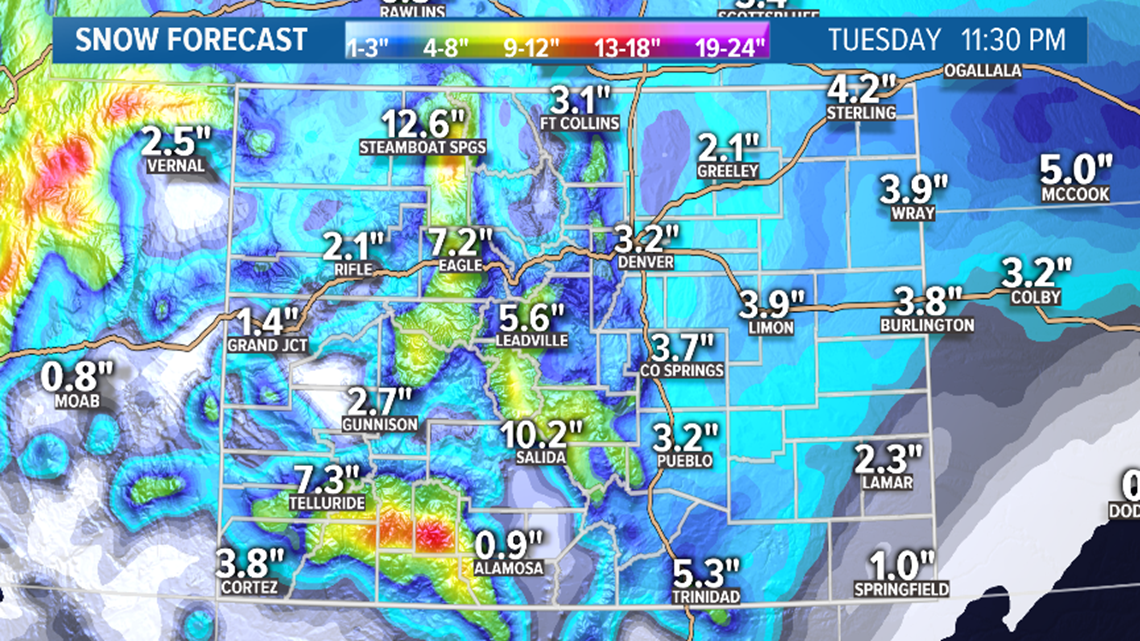
So far this looks like it will have significant impacts to the High Country, and some snow in the Denver metro area as well.
It will be a cold storm with maybe teens by Tuesday morning, and single digits on Wednesday morning in the metro. Storm temps should be mostly in the 20's, so snow will be sticky to the roads in the metro area.

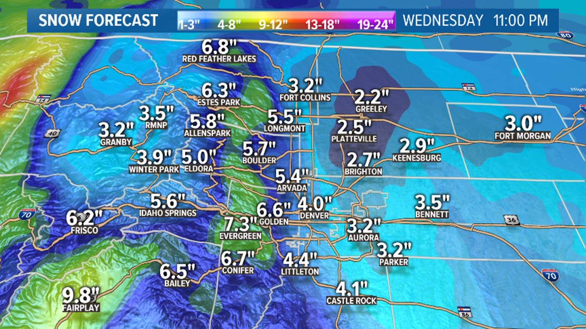
Many of the mountain ranges from south to the north will likely be looking at about a foot of snow, maybe a little more.
It'll be a little drier on the eastern side of the state but snow accumulation will be much more widespread, compared to all the little hit and miss storms of late January.
Early indication from the computer models is for a 1-4 inch range to set up in the Denver area.

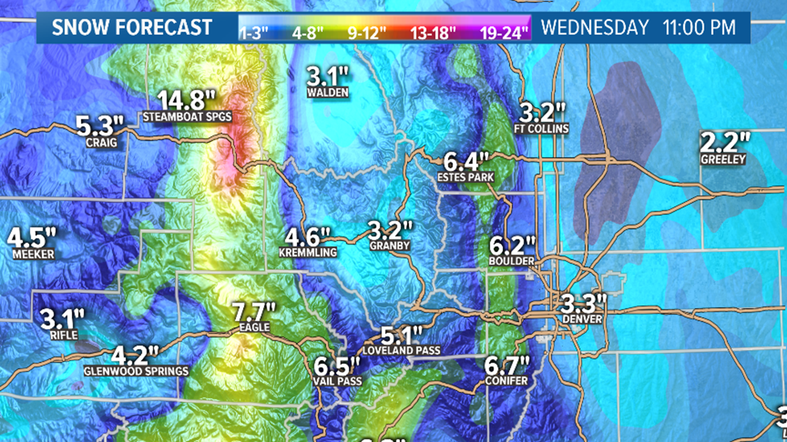
About the same spread for the eastern plains with just a little better chance of getting closer to 4 inches than the metro.
The foothills could be in the higher part of that 1 to 4 inch range.
It will all depend on when and where that piece of energy makes it's move to the northeast, but the models have been very consistent with this so far, so you can bank on there being another winter storm Monday and Tuesday.
Chance of snow in Denver: 55%
Feb. 5-7
Just as those two systems are exiting our area, another storm moves in to the northeast of Colorado. Looks like it will not be a direct hit so westerly flow will limit snow chances for Denver, but there could be a couple of slight chances to pick up a few quick squalls. Models are not indicating much more than an inch total.
The northern mountains, however, could pick up another significant dose of snow with at least another foot. So yeah, more than 2 feet in 5 days. That's decent.
Chance of snow in Denver: 10%
Feb. 8-15
This very active storm pattern may continue on into the second week of February. The GFS is showing more cold air diving down from the Pacific Northwest and meeting up with energy from the southern branch of the jet stream. This would be taking place close enough to Colorado to have a few impacts.
Due to inconsistency in this time-frame so far, there is nothing distinguishable as far as impacts to Colorado yet.
SUGGESTED VIDEOS | Science is Cool


