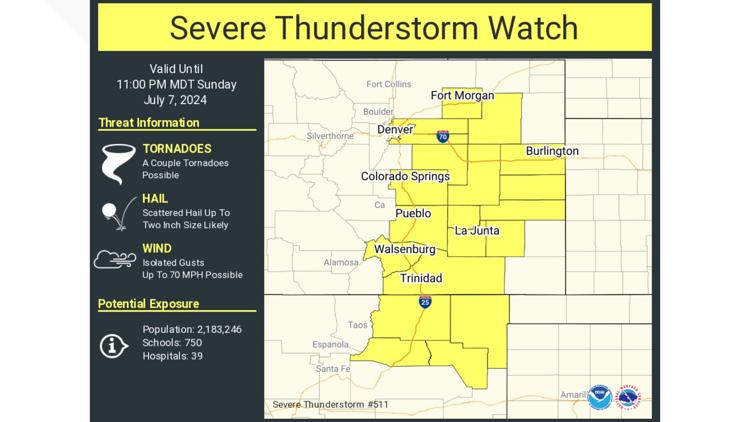
COLORADO, USA — Severe thunderstorms could move through parts of Colorado Sunday afternoon and evening.
The National Weather Service said the strongest storms are expected to the south and east of Denver, especially over the plains.
The following counties are under a Severe Thunderstorm Watch until 11 p.m. Sunday night:
- Adams
- Arapahoe
- El Paso
- Elbert
- Kit Carson
- Lincoln
- Morgan
- Washington
See the most recent NWS-issued warning and watches here.
Scattered storms are forecast to start early Sunday afternoon, developing across Weld and Larimer counties. Those storms will then spread southeast through the afternoon and evening.
The severe weather is most likely in the later afternoon and evening hours across eastern Adams and Arapahoe counties, Elbert County and Lincoln County. The National Weather Center said the biggest threat from these storms is large hail.
The Colorado Flood Threat Bulletin issued a low to moderate flood alert for southeastern portions of the state. There is also a low flood threat for flooding near the Cameron Peak burn scar as rain moves through that area Sunday evening.
The temperatures will rebound slightly on Monday but still stay relatively cool with highs in the middle 80s and lots of sunshine and dry conditions on the Front Range. Tuesday and Wednesday, highs climb even further, into the upper 80s, with slight storm chances Wednesday afternoon.
As we head into next weekend, very hot weather is expected to return. Highs will be in the middle 90s to near 100 degrees Thursday through Monday.
WEATHER LINE 9: Updated weather forecast information at 303-871-1492.
If you have a weather report, photo or video to share, you can contact the 9NEWS Weather Team in these ways:
- EMAIL: Weather photos, videos
- Share updates on our Facebook wall: facebook.com/9weather
- Tweet your updates using the hashtag #9WX or tweet us at twitter.com/9NEWSWeather
SUGGESTED VIDEOS: Colorado Weather