COLORADO, USA — The Denver metro area has enjoyed several snow events since the start of the year -- a welcome relief after the unusually dry weeks in late fall and early winter.
Joseph Kasprzyk, an associate professor at the University of Colorado who focuses on water resources, planning and management, said snow is nature's water tower.
“Snow melts from the mountains, fills the reservoirs, and then reservoirs eventually come and deliver us water supply," he said. "The thing is, Colorado's water supply system is really large and complex.”
“Part of the issue is, these trends can happen across multiple years. So you actually need three to four good years to really be safe because of dwindling supply we have right now,” Kasprzyk said
Becky Bolinger is the Assistant State Climatologist at the Colorado Climate Center at Colorado State University. She answered some of 9NEWS' questions about the state of Colorado’s drought today.
(Editor’s note: This interview has been edited for context and clarity.)
9NEWS: What were drought conditions late last year, in the weeks leading up to the historically destructive Marshall Fire?
Bolinger: We were quickly degrading, and the drought was intensifying through the fall and into the winter. That’s something we don’t normally see, intensifying drought and growing drought in the fall and winter time period.
We were at a place when the fire started where we were probably at the peak intensity of that drought, with the U.S. Drought Monitor showing a “D3” drought over the Denver metro area and a lot of northern Front Range. D3 drought, according to the U.S. Drought Monitor, is just one away from the worst drought category. It basically means you have a 1-in-20 year, or a 1-in-50 year, event of dryness.
In the weeks following the fire, the Front Range has experienced several snow events. Has that helped drought conditions?
Bolinger: It definitely helps. This is all really good stuff. It doesn’t completely erase a D3 drought. We’re talking about a level of severity that takes a little bit more time to recover from.
The snows we’ve had have been wonderful, have resulted in improvements to the drought monitor map, and they will continue to. We should expect to see those improvements over the next week from this snow as well. The recent snow is a really great situation, but it just takes time to get out of drought.
What about longer-term drought conditions?
Bolinger: There is a bit of a dissonance, especially when you’re looking out your window, and I can look into my backyard and I can see tons of piles of snow, so how can we say that we’re in drought? I want to emphasize the difference between short term and long term.
Where we have snow and frozen soils, underneath that soil, moisture might not be going as deep as it would if we had these snow events building on a normal ground that wasn’t suffering from extreme drought. There are things we can’t see that are still there, and I would say that is part of the long-term drought situation.
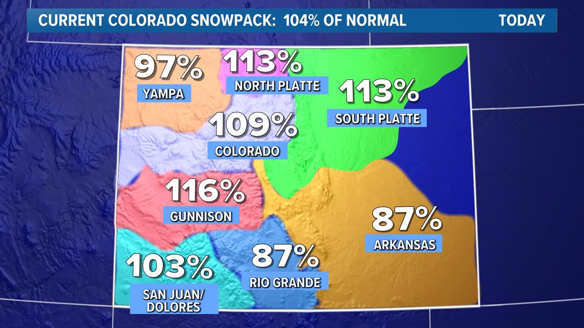
How do snowpack levels look right now?
Bolinger: Our snowpack for the second half of December/first half of January are numbers from mountains where they started to get a lot of activity as well. Those numbers went up well above average. They were in very good condition. That’s definitely good and what we want to see, and has resulted in improvement to long-term drought situations for the higher elevations.
Unfortunately, those numbers have been coming down. They were so far ahead of normal. Now they’re coming down to a bit closer to normal.


SUGGESTED VIDEOS: Science & Weather

