DENVER — The spring storm coming to the Front Range on Tuesday is expected to have a wide range of impacts from heavy rain to wind, lightning and, yes, even big snow.
If there will be any big surprises in the snow totals Wednesday morning, they will likely be somewhere close to the Denver metro area, which does not have a very impressive snow forecast.
With the storm's center of circulation expected to set up in southern Colorado, winds from the northeast will focus the best snow opportunity in the foothills, where there’s the best mix of moisture and colder temperatures.
So places above 7,000 feet could get more than a foot of snow. With more snow likely to the south compared with the north.
Foothills snow forecast
Estes Park in Larimer County is expecting 6 to 8 inches of snow. The forecast in Evergreen is for 10 to 20 inches, and a bit more in Conifer with 14 to 24 inches expected.
Consider it a surprise if any of these locations gets more than 2 feet of snow. A surprise bust would be anything less than 6 inches.
Denver snow forecast
The temperature profile for the Denver area is not favorable for much snow accumulation. While some dry air could help create snowflakes even when the temperature is well above freezing, it won't be until after midnight Wednesday when the conditions become acceptable for accumulation.
Even then, the snow would have to be heavy enough to overcome the ground, which will be wet from the rain. So the forecast for Denver is for just half an inch to 2 inches.
Consider it a surprise in Denver if there is 4 inches of snow or more by Wednesday morning. There would be no low end bust surprise in Denver because it is very possible for no accumulation.
The in-between zone
It's the areas in between the foothills and Denver where the forecast gets a little trickier. The zone between about 5,500 and 6,500 feet can use elevation and topography to keep temperatures on their toes.
The snow forecast ranges between 1 and 5 inches around the west and south side of the metro for places like Boulder, Golden, Morrison, Highlands Ranch, Centennial and Parker.
You can never really be surprised with any amount of snow in this region, but consider a shutout a bit of a surprise here. Anything above 6 inches would also be considered a mild upset.
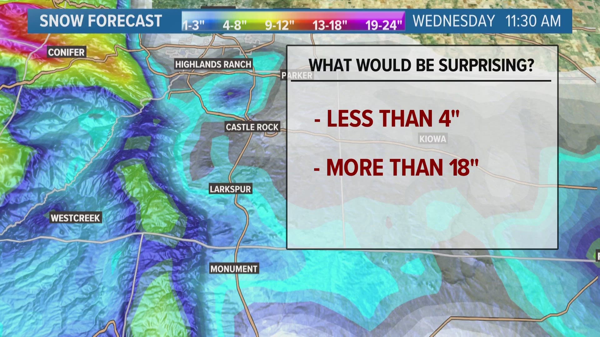
Palmer Divide snow forecast
Up on the Palmer Divide, there is a wide range of snow expected with anything between 4 and 14 inches in the forecast.
- Castle Rock: 4 to 8 inches
- Elizabeth: 5 to 9 inches
- Larkspur: 8 to 12 inches
- Monument: 9 to 14 inches
This could be another area primed for an upset, as a few computer forecast models are showing 2 feet of snow in spots. Consider anything under 4 inches a surprise here.
SUGGESTED VIDEOS: Severe Weather
9NEWS+
9NEWS+ has multiple live daily shows including 9NEWS Mornings, Next with Kyle Clark and 9NEWS+ Daily, an original streaming program. 9NEWS+ is where you can watch live breaking news, weather updates, and press conferences. You can also replay recent newscasts and find videos on demand of our top stories, local politics, investigations and Colorado specific features.
To download 9NEWS+ on Roku search for KUSA.
To download 9NEWS+ on Fire TV search for 9NEWS.

