COLORADO, USA —
Friday Update:
Dec. 28
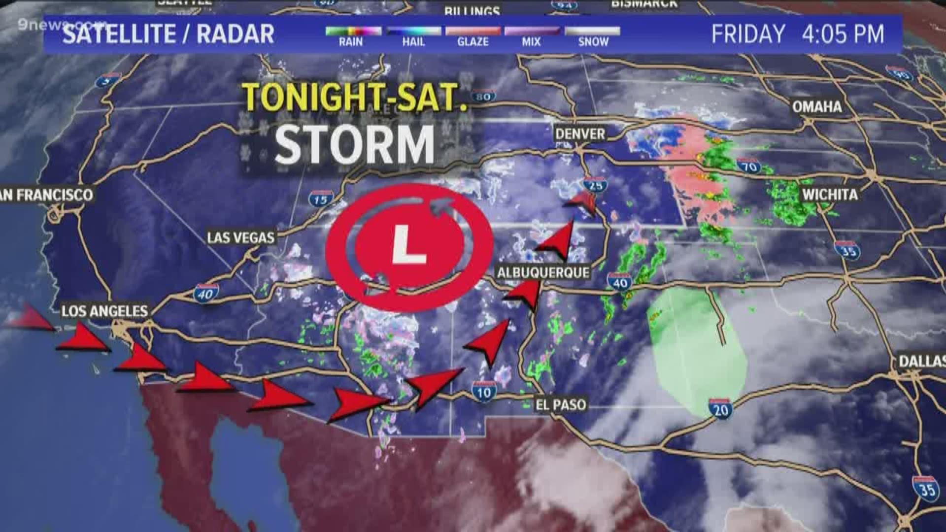
In the computer modeling, there is no great indication of what will happen with Saturday's snowstorm but here is what we know:
- A large storm system is moving across the Rocky Mountains and will bring snow to the Front Range, Denver, and the Eastern Plains.
- That storm has a history of producing bad weather from Southern California to Arizona, and into Southern Colorado.
- There is agreement in all the modeling that the storm will be disrupted quite a bit as it comes over the mountains. So it's just a matter of how fast will the low levels of the storm system reorganize, and where will the dominant low-level circulation set up
- No matter where and how fast that low sets up, the best timing for snow to start is around midnight tonight, and it should at least be able to last until sunset Saturday.
- Because of terrain, the Denver metro area will get snow. The most accurate model historically, the European, is showing 2-4 inches, but the GFS which has not been that good in the past, but has been good this season, is showing 4-8 inches.
The GFS has been good enough, that it's solution should be accounted for in your planning for tomorrow. Four inches of snow in the metro would make both models right, and would also be enough to cause trouble on the roads.
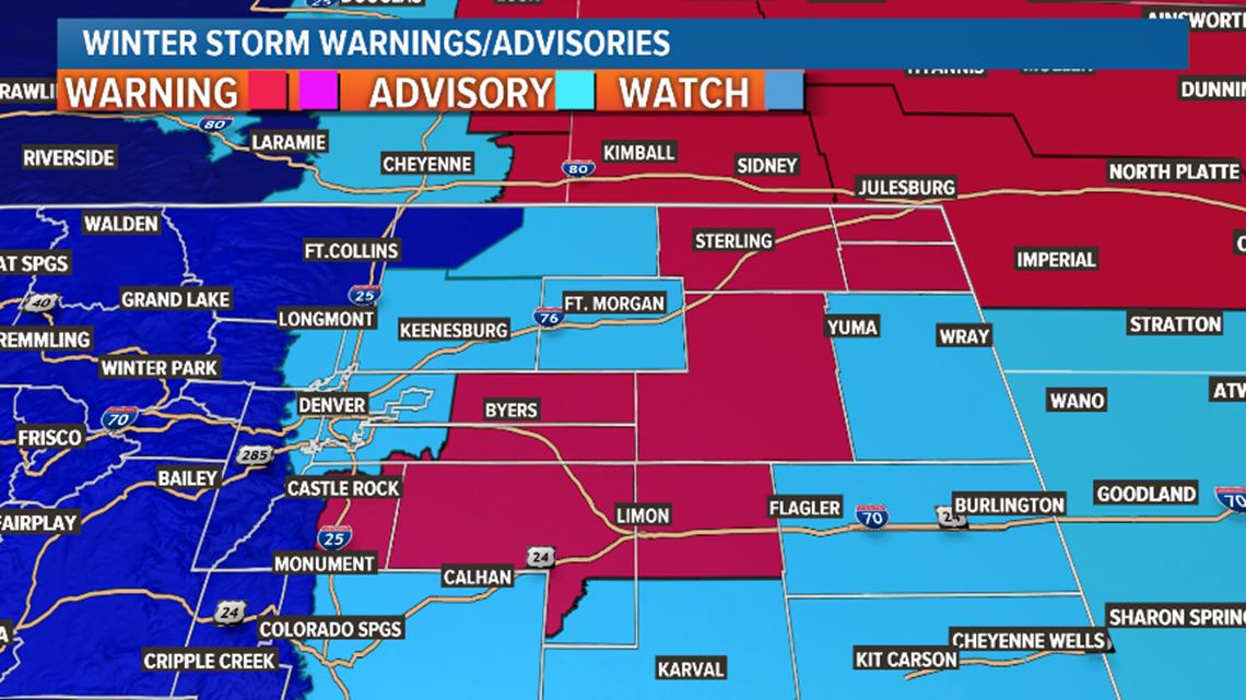
- There is also quite a bit of uncertainty on the eastern plains, but the potential for high winds and snow up to 8 inches is there. The winds will likely be very widespread, but the 8 inches of snow will not. There is not an area that has the highest chance of getting that in Colorado, but it will likely be north of I-70.
If you live on the northeast plains of Colorado, you should prepare for near blizzard conditions for most of the day Saturday, with the potential for road closures.
- The highest chance to get widespread blizzard conditions is the Nebraska Panhandle. All models do agree with that.
- Also due to terrain, the Palmer Divide has a high chance of blizzard-like impacts. Those areas are under a Winter Storm Warning for that reason. That's east Douglas, Elbert, east Arapahoe, and north Lincoln Counties. The south side of the Palmer Divide usually gets less impact due to downsloping winds from the north.
- The storm is moving northeast and will strengthen as it moves away from Colorado. Bigger problems await northern Nebraska, the Dakotas, and Minnesota. It should release its grip on the northeast plains of Colorado by Sunday afternoon.

Jan. 1-2
The next storm we'll be watching comes into Colorado on New Years Day. This looks like it will mostly impact the northern mountains with 4-8 inches of snow. There has been good indication that snow will be possible in the Denver metro on Thursday morning. So far just showing up as an inch or two.
Chance of snow in Denver: 20%
Jan. 4 - 6
No consistent signal with a couple of light mountain disturbances here.
Chance of snow in Denver: 0%
Jan. 7-12
A storm signal in this window has been getting stronger for the second day in a row, but nothing as far as timing or intensity.
----
Thursday Update:
Dec. 27-28
Mountains - A very large and powerful storm is moving out of Southern California into the desert southwest. This will bring snow to Arizona, New Mexico, and southwestern Colorado.
A Winter Storm Warning for the San Juans goes into effect late Thursday night with 10-20 inches of snow expected on the mountain passes. Meanwhile, 7-14 inches are expected in some of the mountain towns like Pagosa Springs, Silverton and Telluride.

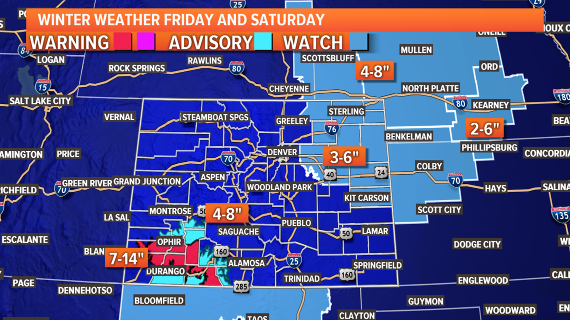
Snow should start late Thursday night and last until early Sunday morning.
Northeast Plains - There is a watch in place for the storm on the northeast plains. Over the past 36 hours, the computer models have switched the track of the storm from more of a southeast Colorado and Kansas impact to now more of a northeast Colorado and Nebraska impact.
The Euro shows a slower development of the leeside low which would bring it into blizzard position for the northeast plains. At 20-30 mph winds, it would be just shy of the threshold for a Blizzard Warning, but winds will be the big story with this storm anyway.
There will likely be two waves of storms. The first, on Friday afternoon, could bring some very heavy snow, mixed with some rain and sleet in spots. Then another wave on Saturday morning could bring some of the strongest wind gusts.
It shows areas east of Denver and north of Interstate 70 getting about 3-6 inches of snowfall, which usually amounts to some large snow drifts in the 2-3 feet range. With the visibility and icing issues, I would expect several roads to close.
So far, it shows Nebraska as the bullseye of the storm, but some areas, like north Washington, north Yuma, Morgan, Logan, Phillips and Sedgwick counties, have the highest chance of getting more than 6 inches.
Then there is the issue of the GFS. This model has been showing a different solution that would double the snowfall totals. Normally when this happens, it gradually drifts closer to the Euro's solution, but all three runs so far today have not wavered. I don't see any reason to give it a whole lot of weight just yet, but we can't discount what this model is trying to tell us either.
Prepare for a rough storm out there on the northeast plains.
Southeast Plains - The really bad impacts seem to be fading from possibility on the southeast plains but there will still be some storms there. I would expect a mix of rain, sleet and snow there starting on Friday morning.
It looks like there may be enough snow there for some accumulation of 1-2 inches, with a little more as you get closer to Interstate 25 to the west. Maybe 2-4 inches there.
It's possible there won't be too much impact there on Saturday though, except for some scattered showers and some wind. We're not expecting any advisories south of Cheyenne County.
Front Range - The storm might just be a little too far away from us for any major impacts, but a few advisories will be possible. If we do get any advisories in our area, they will probably be on the Palmer Divide or east Denver metro area.
We could start getting some snow squalls by late Friday morning. This could be heavy at times, but not too long-lasting. Expect a more consistent snowfall early Saturday morning.
Wind should be less of an issue, but we will probably end up with a spread of 1-4 inches of snow on the Front Range with the larger numbers east and southeast of Denver. If we get a little surge of upslope wind; some of the foothills areas could get close to four inches as well.
Usually with these north winds, the I-25 corridor between Denver and Ft. Collins gets left out of the heavier snow, but there should still be a little along that region.
The GFS solutions would also double the snow totals for the Front Range, so we will have to see if that starts to change as the storm gets closer.
Jan. 1-2
Another storm looks likely on New Years Day, which means we won't have to wait long for our first snow of 2020 in Denver. So far it looks like low impacts of just a couple inches.
Chance of snow in Denver: 20%
Jan. 3 - 5
The storm in this window looks to only have some mountain impacts
Chance of snow in Denver: 0%
Jan. 7-11
Two storms currently showing in this window. Not any strong signals though.
-----
Tuesday Update:
Dec. 25-26
White Christmas- Snow will continue to fall over night and into the morning on the Western Slope of Colorado which means many of the those areas out there will see snow on Christmas morning. Some of the spots that have been getting rain today, will switch to snow late tonight.

That snow will press to the east giving the rest of the state a chance to see some Christmas snow. The showers will be much more scattered there though, so many of us will miss out. The ones that do get it, may only see the flakes falling from the sky with no actual accumulation. Best chance for the Denver area will be in the evening, but a few showers will be possible at anytime tomorrow.

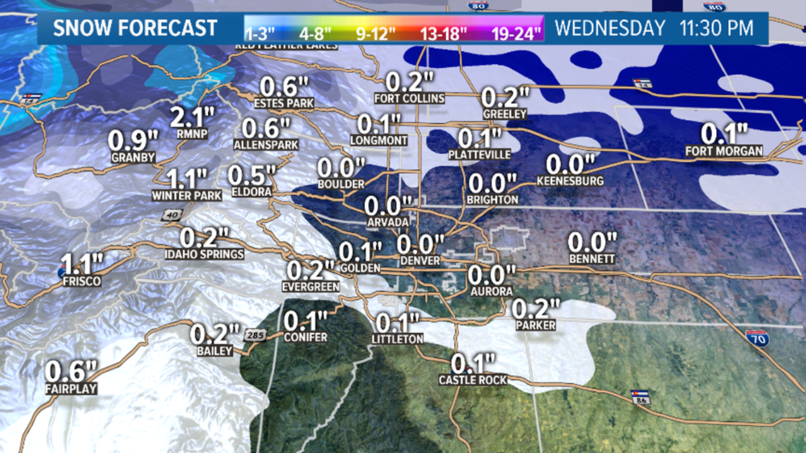
Showers in southeastern Colorado may be more rain than snow. GFS shows a similar solution to the Euro with widely scattered rain and snow showers all across the plains with little accumulation and low coverage.

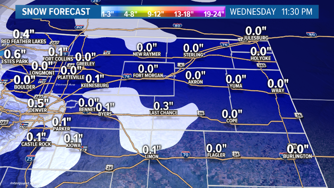
Due to the chance for some rain, along with the scattered and light nature of the showers tomorrow, the chances for snow in Denver remain fairly low. Some of the area is very likely to get snow Christmas evening though. Most models show about 20 percent of the area getting covered so lets go with that.
Chance of snow in Denver: 20%
Dec. 27-28
The models have been trending down with the intensity of the Friday storm on the southeastern plains. It will all depend on where the energy from the northern jet stream meets up with the energy coming from the south.

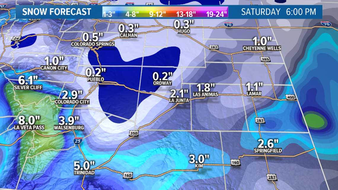
Nothing certain here yet, but it is a good sign this is trending down because that was looking pretty nasty for people trying to get back home from the holiday break.
There continues to be very little impact shown for the Front Range with this one.
Chance of snow in Denver: 10%
Dec. 31 - Jan.1
Looks like this split jet stream trend is continuing in the models. There could be another meeting of troughs sometime around New Years Day. Looks to be low impact so far though.
Jan. 3 - 9
A battle between a southern moving storm track and western ridging seems to be setting up for January. That would limit our storm chances, and would make it nearly have to be a direct hit to get anything good here. This would also continue the trend of unseasonably warm temperatures like December, which will likely finish as the warmest in 25 years for Denver.
-----
Monday Update:
Dec. 24-26
Tuesday- A large trough of low pressure is gradually bulging eastward towards Colorado. Snow and rain chances will be possible at anytime over the next three days across the state.
Scattered snow showers will develop very late tonight into early Tuesday morning on the Western Slope of Colorado, but the bigger wave of snow, with more coverage, will be in the afternoon.

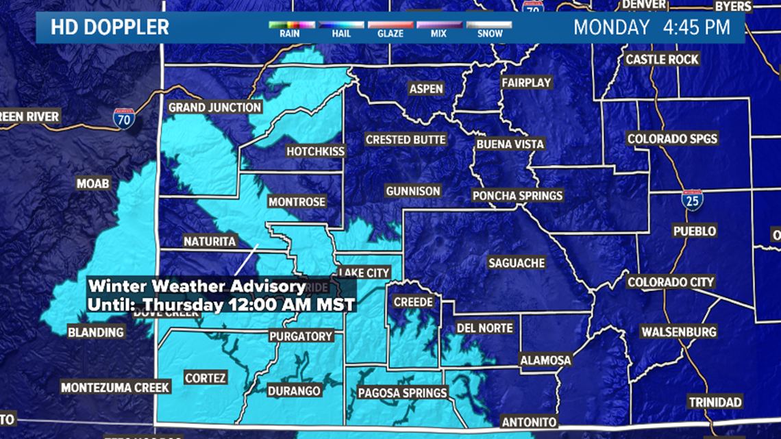
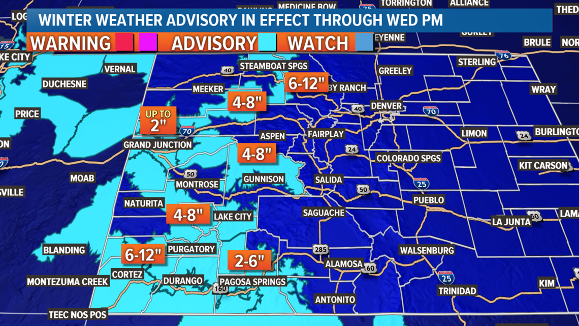
A Winter Weather Advisory is out for southwestern Colorado for 6-12 inches of snow by 6pm Wednesday. Less snow in the mountain towns, but Telluride could get 3-6" Tuesday. The Euro shows 3.9" there by 11pm Tomorrow night.

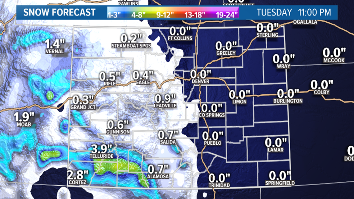
Snow and rain showers will attempt to cross the state a few times on Tuesday, and a few showers could reach east of the Continental Divide. I would say a few showers could even make it onto the Palmer Divide or south metro. Depending on what time of day a shower pushes through, it could even be snow flakes that fall instead of rain. Highest chance for the Front Range would be Tuesday night. I wouldn't expect there to be any accumulation though if by some chance a shower makes it over.
Wednesday- Snow continues through the day on Christmas. Models show a White Christmas in places on the Western Slope like Telluride, Grand Junction, Rifle, Aspen, and Steamboat. Several more spots with between a half inch and and inch of Christmas snow (that totally counts).

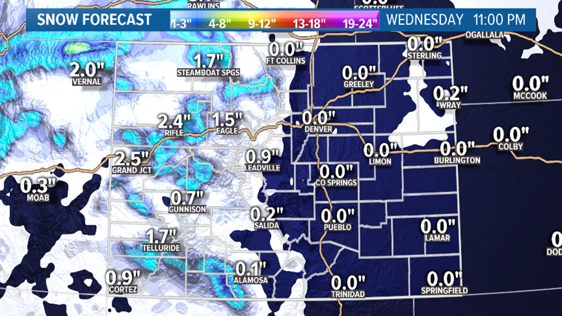
Places on the Front Range will have two chances on Christmas Day for snow although by the accumulation models, it doesn't look to be enough to accumulate in most spots.
First chance will be with the scattered showers that lingering around on Wednesday morning. Then another chance in the late evening. Some spots on the Palmer Divide and eastern plains could even get a couple inches out of it, but those areas that get the snow will likely be very isolated.
Thursday- Snow showers lighter in the mountains Thursday, especially after noon. There will even be a chance at a few snow showers down on the plains until about 6pm. Not very impactful though.
Both the GFS and the Euro show zero snow accumulation at DIA through this storm period, but there is a decent chance that one of these waves will drop at least a little snow in there area at some point over the next three days.
Chance of snow in Denver: 30%
Dec. 27-28
The computer models still show a storm taking a southern path across the bottom of Colorado on Friday. It still looks to be fairly potent too.
That location in the GFS modeling would bring very little impact to the Denver metro and the Front Range, but blizzard conditions could develop on quite a bit of the southeastern plains.
The storm location in the Euro's modeling would be further south hitting mostly the Oklahoma Panhandle with the southeastern corner of Colorado and parts of southwestern Kansas.
The current timing looks to be Friday after noon to about 5am Saturday morning.
Chance of snow in Denver: 10%
Dec. 30 - Jan.2
Models show another storm drifting down the west coast of the country, but it gets pinned there by a strong ridge of high pressure. This is the second day in a row of modeling that shows no impact to Colorado.
Jan. 3 - 8
A weak shortwave is finally shown getting out of that troughiness in California with little impact on Jan.3-4. A few weak signals after that as well, but only resulting in some light mountain snow.
-----
Sunday Update:
Dec. 24-26
Timing is just right for a Christmas storm this year, although it looks like it will be a fairly weak one. That still means a White Christmas for many parts of Colorado. Even the Front Range will have a shot.
The storm will be focused on the San Juan's where 6-12" of snow looks possible over a 3-day stretch. There may be Winter Weather Advisories issued by Monday.
Most of the Western Slope of Colorado will have a high chance of having snow falling on Christmas Day.
The storms will spread east by Christmas morning which means even the Denver metro, the Front Range foothills, the Palmer Divide, parts of the eastern plains, and the I-25 corridor will have a decent shot at seeing a White Christmas.
That's if you call snow flakes falling a White Christmas because very possible that none of it sticks to the ground. With warm temperatures it may be just drizzle at times.
The Euro model shows a few mixed showers around our area on Wednesday morning and evening, and then again on Thursday morning. It even shows it just heavy enough in a few spots to accumulate on the ground, but less than a half inch.
The only place it shows more than an inch east of the Continental Divide is Estes Park with about an inch and a half. I believe that is about what they got last Christmas or maybe that was Christmas Eve.
The GFS also shows a little Christmas snow in the metro area, but it shows a higher chance on Thursday morning.

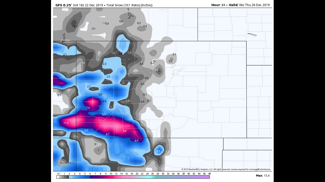
Even though the models show some pretty warm temps (upper 20's) for most of this storm, and only spotty showers, it's just enough of a signal to raise the chances of a White Christmas in Denver just a tad. Remember, I say if there is just a few flakes falling that counts.
Chance of snow in Denver: 20%
Dec. 27-28
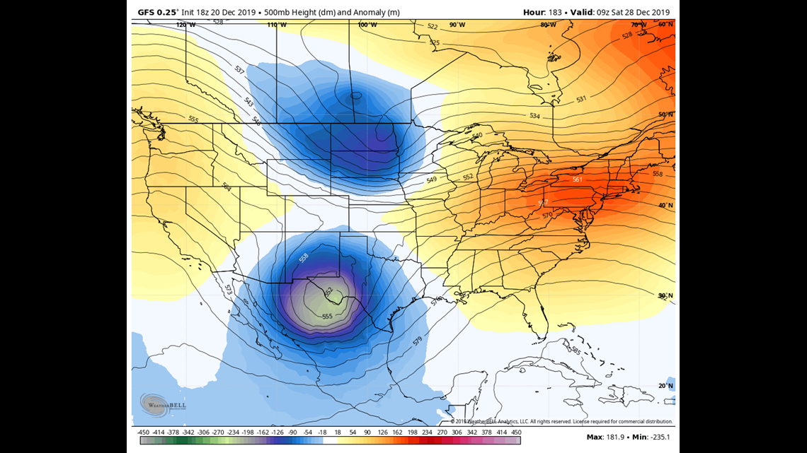
The GFS has quite consistently shown a strong southern storm track around Saturday Dec. 28. On recent runs it has sped up that storm to hit more on Friday.
The southeastern Colorado plains will have to contunue to watch this storm develop because the current solutions bring a dangerous prairie blizzard to a big chunk of the area including the Highway 50 corridor into Kansas.
This could be bad timing for travelers trying to return for the holidays. Current solutions show the storm with big impacts all the way through eastern Kansas, then on into the Great Lakes region.

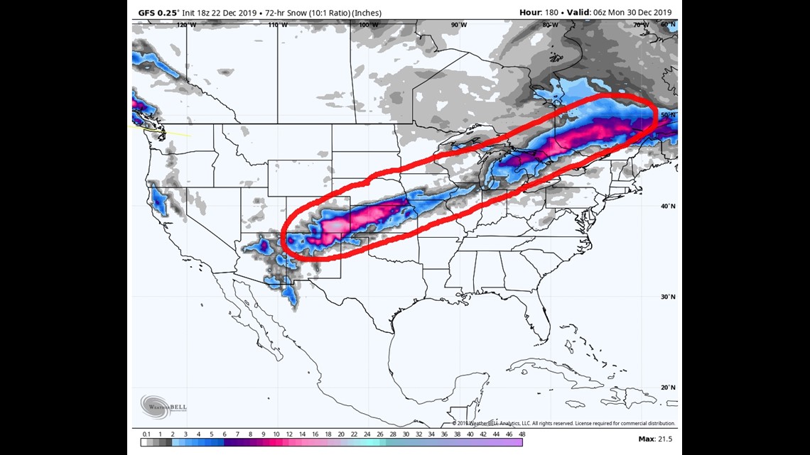
This storm should also be close enough to Denver to bring some snow here as well. Probably not a huge impact. Just a couple inches of snow accumulation. The Palmer Divide and the I-70 east corridor could have a little more impact though.
The latest Euro has a similar solution.
Chance of snow in Denver: 10%
Dec. 31 - Jan.3
This storm has not been showing up in the latest modeling.
Jan. 5 - 7
There is a storm signal here in the latest GFS
-----
Friday Update:
Dec. 24-27
The Christmas storm is still just hanging in there with the models, but mostly on the day before, and mostly on the Western Slope. The Front Range may be losing it's chance to get that one snowflake to fall out of the sky for Christmas.
The area that has the best chance to see a White Christmas will be southwestern Colorado, in particular, the San Juan Mountains. Might even be heavy enough to see some advisories or maybe a warning issued for Tuesday and Wednesday.

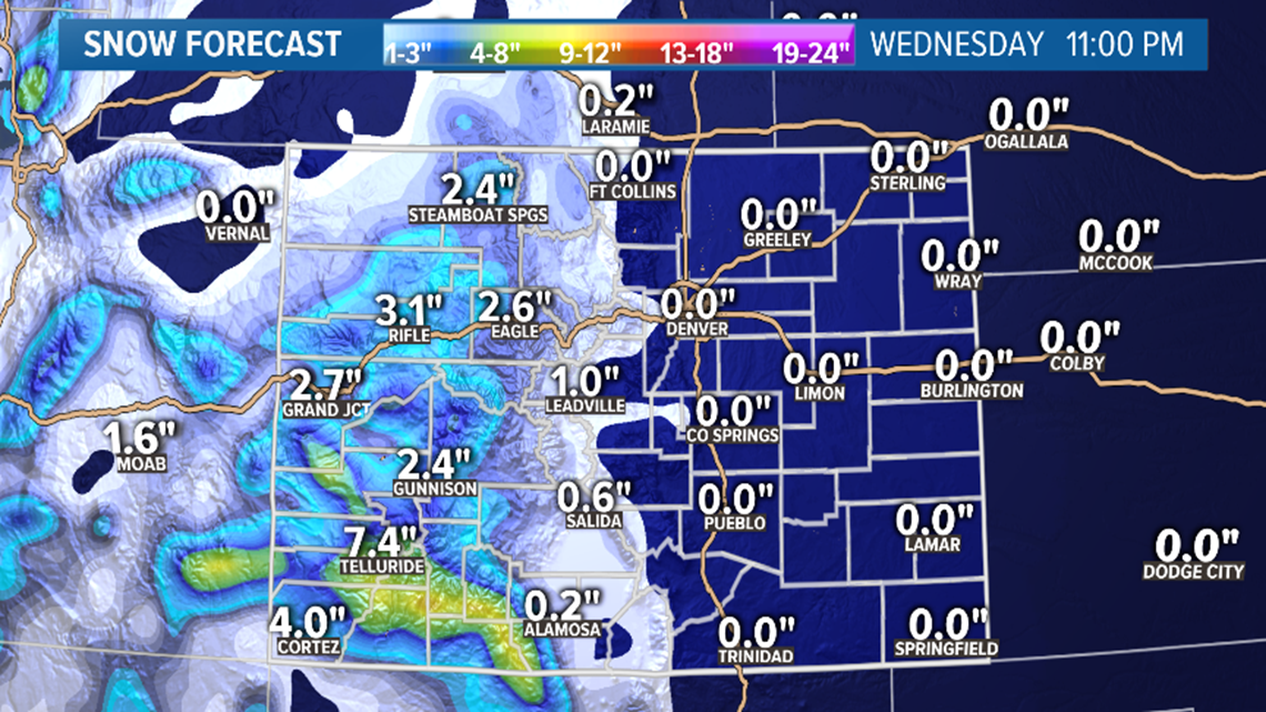
Both models continue to show most of the snow falling on Christmas eve, but some still falling on Christmas Day as well. Most of it will likely just be on the western half of Colorado.
One last chance the day after Christmas for the Front Range, but it may be very light and it may also be too warm for it to be snowflakes. Storm moves out of the state on Friday morning.
Chance of snow in Denver: 10%
Dec. 28-29
Day 5-10 in the modeling has been very inconsistent lately. Although there is still a more organized storm system being shown for the next weekend, both models are showing a jet stream split with the storm going completely around the state of Colorado. That would have very little impact to us if that happens.

Chance of snow in Denver: 0%
Dec. 31 - Jan.3
This storm system is still shown as a trough diving down the coast of California, but it shows no impact on the way down, just on the way out now. That would bring the best chance of snow in Colorado on Jan.2-3, instead of New Years Day.
----
Thursday Update:
Dec. 24-27
There were some changes in the modeling today, but there still looks to be three separate systems headed to Colorado. Two weak ones from Tuesday to Friday, and then a stronger one on the tail end.
I'll separate them a little different in the blog now.
The GFS has sped up the first storm quite a bit which would eliminate the chances at Christmas snow for most of Colorado. This is a pretty big change from yesterday's runs, but the solution is holding through tonights run.
It has snow still starting early Tuesday morning in the mountains, but it now has it ending well before sunrise on Christmas. It also now shows much less snow except in the San Juans in southwestern Colorado.
It does have some light snow accumulation in the Denver area on Christmas Eve night, but it is less than an inch.
The Euro however, is holding with the Christmas snow solution. It also has light snow of less than an inch in the Denver area, but it has it on Christmas morning instead of the night before.
All together still a very good chance that Colorado will have a least a small winter storm on our hands Christmas Eve and Christmas Day. The chances of snow remain low, but it's still out there.
The second surge looks quick an weak on Dec 26-27. Models have not been showing any impact to the Front Range with that one.
Chance of snow in Denver: 15% (either Tuesday night or Wednesday morning)
Dec. 28-29
I separated this storm out of the mix because it looks much more organized, but it is the third storm in quick succession here. Models show this one drifting across southern Colorado while undergoing rapid intensification.
So far it has been showing this strengthening too late for major impact to the Front Range, but it has shown some big impacts to southeastern Colorado, and with this latest run it has moved that up to northeast Colorado. It's really close to the Front Range sweet spot though, so let's watch this one close.
Chance of snow in Denver: 0%
Dec. 31 - Jan.3
Models continue to show a very active storm pattern, but just missing the Front Range with most of them. A few storms will likely be nearby during this time frame, but the GFS has switched from the one on New Years Eve bringing the metro snow, to the one on Jan 3. So no consistency yet.
-----
Wednesday Update:
Dec. 19
There is a little weather system that will pass by Colorado late tonight. May bring slightly cooler temperatures to the Front Range tomorrow mostly due to cloud cover, but still should make it into the upper 40's.
No precipitation with this system down low, but it could bring a dusting of snow to the high mountain areas of southern Colorado above 12,000 feet.
Chance of snow in Denver: 0%
Dec. 24-28
After a warm dry week, a couple of surges of cold air will move down the west coast and head towards Colorado by Tuesday.
While it doesn't look like much, the models are keeping snow solutions in play for the Denver metro area on Christmas. Most of the runs are showing less than an inch, but if I see as much as one flake fall to the ground on December 25, I'm calling that a White Christmas.
Snow may start falling on the Western Slope on Tuesday morning. The GFS is showing just about every spot west of the Continental Divide with a change at some Christmas Snow. Even the lower areas like Grand Junction. It does not currently show any snow in the metro.
The Euro however does have some snow in the Denver metro on Christmas. It has only been showing a little less than an inch, but most of the models usually drift towards the Euro in most cases.
There may be an active little stretch of storm chances here, but the Euro does not show much strength with the second storm like the GFS does. It shows a strong southern storm track that brings a small dose of upslope snow to the Denver metro on Saturday Dec. 28.
Chance of snow in Denver: 15%
Dec. 30 - Jan.1
This storm is still showing up in the modeling and the latest runs shows snow coming to the Denver area on New Years Eve night, so this one we better keep an eye on.
----
Dec. 19
Before we get to the storm coming next week, there is one little upper air disturbance that will be passing by Colorado on Thursday. This looks like it will not deliver any precipitation to the state.
It may be completely unnoticeable to most of us, barely dropping the temperatures or kicking up any wind.
The core of this trough will pass just south of Colorado and may have very little impact on the country until it gets way southeast. Many of the model runs show this system making it into the Gulf of Mexico and taking on some sub-tropical characteristics. That could bring some severe weather to Florida this weekend just as the busy holiday travel season gets underway.
Chance of snow in Denver: 0%
Dec. 24-28
The computer models have been consistently showing a storm system diving down the west coast and swirling into the Rocky Mountains by Tuesday next week.
Before we get into that, it is important to point out that the entire country from the Rockies to the Atlantic coast will be experiencing clear, dry and unseasonably warm weather while trying to get to holiday destinations Saturday through Tuesday.

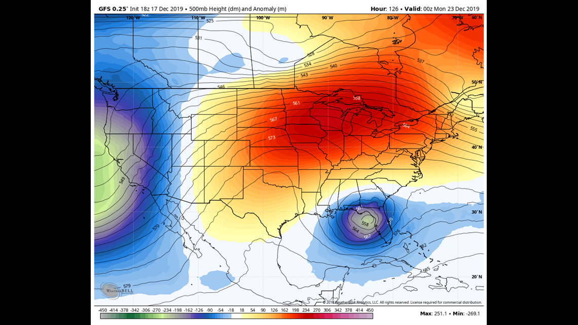
There will be that hybrid subtropical system down near Florida this weekend, while the Sierra-Nevada's, the Las Vegas area, as well as parts of Arizona and New Mexico get hit by a winter storm on Sunday and Monday.
That storm will continue to develop and head into the Colorado Rockies by Tuesday Dec. 24. Models show snow actually starting in Southwest Colorado on Monday night and lasting into Christmas morning. Looks like 2-6 inches in some of the mountains by sunrise on Wednesday. The GFS is even showing some snow in Grand Junction on Christmas morning.
There looks to be a second surge of cold air getting sent down just behind this one that may bring continuous storms to Colorado through Friday.
The second storm appears to be the more powerful and organized.
There may be a shot for parts of the Front Range to get some Christmas snow between the two surges.
The current timing shows the snow creeping closer to the Denver metro area late Wednesday night and bringing a little bit of snow to the Front Range on Thursday, the day after Christmas.
The bulk of this storm is shown impacting southeastern Colorado on Thursday and Friday. While travel to holiday destinations will be easy, the return trip may be hindered by this storm from southern Colorado and New Mexico straight up through Kansas, Iowa and Wisconsin.
Chance of snow in Denver: 10% (either Wednesday night or Thursday morning)
Dec. 30 - Jan.1
There is another southern style storm track showing up in the modeling during this time-frame. It looks like mostly the western slope and the San Juans will be impacted by some snow.
SUGGESTED VIDEOS | Science is cool

