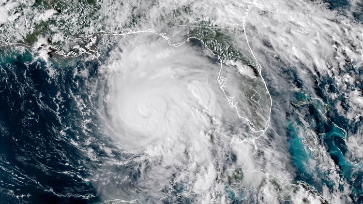
KUSA — All eyes were on Hurricane Michael on Wednesday morning, as it rapidly made its way toward the Florida panhandle.
Images of from satellites were mesmerizing. Thanks to new satellites, we are getting an unprecedented views of this incredible force of nature.
According to Dan Lindsey, Atmospheric Scientist with NOAA/NESDIS and currently a Senior Scientific Advisor for the GOES-R, new satellites like the GOES16 satellite can take an image every 30 seconds – so it’s basically time lapse photography from space.
“The result is, you can see details on the eye of the storm, we’ve never been able to do that before," Lindsey said. "The other thing is the resolution has gotten a lot better from previous satellites, so we can see features, and details in the eye that we weren't able to see before."
Lindsey explains that when looking down the eye of Hurricane Michael, researchers and forecasters can “meso-vortices." For those of us who aren’t scientists, that basically means they’re mini spinning areas, larger than tornadoes, but smaller than the eye itself.
“You can see in that eye, and that tells us it’s an extremely strong storm,” Lindsey said.
Hurricane Michael is considered one of the strongest hurricanes to ever hit this part of the United States, but thanks to newer satellite imagery, forecasters can track storms almost in real time.
“The forecasters at the National Hurricane Center and the National Weather Service can see an image on their screen within a couple of minutes from when the image was taken on the satellite," Lindsey said. "And that’s something we weren’t able to do before, so if you see any changes in the satellite imagery, the forecasters know that really quickly. Previously they would wait, 15, 20, 30, even 45 minutes before they would be able to see the image.”
Lindsey adds that forecasters for Hurricane Michael knew a few days in advanced that the storm would be very strong because of numerical model forecasts.